Home » Transportation » Recent Articles:

Changes Needed on South Broadway to Prevent More Pedestrian Deaths

For over a decade I’ve written about pedestrians, including pedestrian deaths. It’s difficult to visit the sites and write about how the area could be designed better, but nothing like the pain experienced by the families & friends who’ve lost a loved one. Most recent was Bapi Gupta:

Gupta’s mother, Genie Dee, and Georgie Busch, who lost her daughter, Amber Wood, in a hit-and-run accident in the same location in 2012, are hoping to bring change to the stretch of roadway.

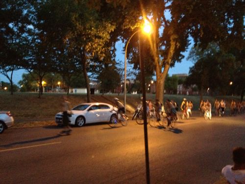
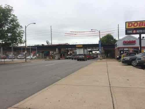
The string of fatalities and near misses has many calling for slower traffic in the area.

“Why is it 35 miles an hour here? Why isn’t there a stop light up the street here, which they took down, by the way,” said Michael Chekoudjian, the driving force behind a change.org petition asking for changes to the area. (KMOV)

From the change.org petition:

With 3 fast lanes of traffic heading south, trying to beat the lights cars are exceeding the speed limit by 20 to 50 MPH. This is very Dangerous in an “Entertainment District” with as many as a 1000 people in the streets at times and as we know by the hit and run death of “Amber Wood” at the 700 block of Broadway in April of 2012 this is a very dangerous stretch of roadway. We the signers of this petition want Mayor Slay to put a stop to this speeding on this dangerous stretch of road in the name of “Amber Wood” NOW!

First let’s look at a couple of recent suggestions offered by family & friends:

Lower the posted speed limit: Motorists currently exceed the 35MPH speed limit, they’ll drive the same speed regardless of the posted limit. This is because people drive at what they perceive to be a safe speed based on the design of the road. If you want to lower the speed — you must change the design! More on the design later.

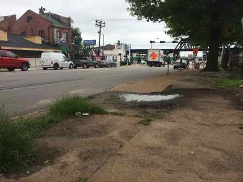
Traffic signal at previous intersection: The previous light at Cerre St was removed when a new ramp onto Eastbound I-64 made it a dead-end street. Putting a signal back doesn’t make sense. However, a flashing yellow signal overhead would be a good idea, changing to red if activated by a pedestrian wanting to cross Broadway.

There are things that should change, let’s take a look:

A lot of the traffic on Broadway gets on Westbound I-64 before getting to the commercial district where pedestrians have been struck & killed.
Approaching Cerre St from the North.
After many get on the highway the remaining traffic now has more room, so they can speed up. Looking South from from just South of Cerre St, three wide traffic lanes in one direction plus parking lanes on both sides. This is designed to move cars quickly, not a good design for the commercial district just beyond the elevated train tracks. The vehicles you see are a deep line stopped at Gratiot St.
This is the pedestrian environment across the street from the Broadway Oyster Bar.
Looking East at Gratiot St we see the traffic light is green but the pedestrian signal is "don't walk" Broadway Oyster Bar is on the left. Also not the curb bulbs out into both Gratiot & Broadway.
Looking East at Gratiot St we see the traffic light is green but the pedestrian signal is “don’t walk” Broadway Oyster Bar is on the left. Also not the curb bulbs out into both Gratiot & Broadway.

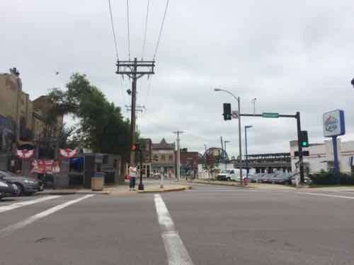
I sat here for a few cycles to time the lights. For vehicles the light is green for about 38-40 seconds. However, the pedestrian signal is “walk” for just 4 seconds before it begins to flash! It flashes for 10-15 seconds before going to a solid don’t walk, but the traffic signal remains green. Having such a short walk time with a longer traffic time encourages pedestrians to go for it rather than wait on the longer Broadway signal.  The pedestrian signal timing needs to change immediately! Ok, let’s cross.

Looking North we see how the "curb bulb" encloses the end of the parking lane on the East side of Broadway, Why wasn't the curb on the West side bulbed out as well?
Looking North we see how the “curb bulb” encloses the end of the parking lane on the East side of Broadway, Why wasn’t the curb on the West side bulbed out as well?

Based on my visit, here are my suggestions:

Immediate solutions:

  • Change pedestrian signal timing at Gratiot.

Short-term solutions:

  • Reinstall traffic signal at Cerre St., on yellow flash, changing to red if activated by a pedestrian.
  • Restripe Broadway, narrowing the 3 drive lanes.
  • Add a solid white lane to separate the outside drive lanes from the adjacent parking lanes.
  • Change pedestrian signals to have a countdown timer.

Long-term solutions:

  • New streetscape, putting the road on a diet with curb bulbs at all corners. Include mid-block planters in the parking lanes.
  • Return 4th & Broadway to 2-way traffic.

More observation, at different times, is needed. But this area must change or we’ll see more pedestrians hit.

— Steve Patterson


Saturday July 18th: World Naked Bike Ride St. Louis

Tomorrow night is one of my favorite events — the World Naked Bike Ride:

The World Naked Bike Ride in St. Louis is part of an international event to raise awareness of cyclist rights and vulnerability on the road, and promote positive body image and  protest oil dependency.

This year’s 8th annual World Naked Bike Ride in St. Louis will take place on Saturday, July 18. The pre-ride WNBR festival and rally will take place on Manchester Ave. in the Grove,  between Sarah and Kentucky. Stay tuned for more details on the time of the event!

Ride safe and at your own risk! (World Naked Bike Ride St. Louis)

2012: World Naked Bike Ride St. Louis on Lemp Ave

From the World Naked Bike Ride St. Louis website:

A few important things:

  • We encourage you to be safe, wear a helmet and have lights on your bike
  • We ask that photographers and press help create a safe space by being respectful and asking CONSENT to photograph, and encouraging others to do so!
  • Although you can be as bare as you dare during the ride, the St. Louis city requests that we cover our privates at the pre/post party

This year’s ride is 12 miles through the city, see the route here. The ride starts & stops on Manchester in The Grove.

If only I could still ride a bike…

— Steve Patterson


Reading: Roads Were Not Built for Cars: How Cyclists were the First to Push for Good Roads & Became the Pioneers of Motoring by Carlton Reid

Click image to hear a webinar featuring author Carlton Reid

When I had my stroke in February 2008 I owned 5-6 bicycles, the oldest was a very original 1950s Huffy. I kept my bright orange Kronan, a reproduction of a single-speed WWII Swedish Army bike, as art. I love all things bicycle.

My library includes a few coffee table books on bicycles and their history. Those books briefly touch on early dirt roads and how cyclists pushed for better roads on which to ride, but they quickly get into the various bike designs, mechanicals, etc. A new book just out focuses not on bicycles, but on the early cyclist’s push for better roads. In ‘Roads Were Not Built for Cars: How Cyclists were the First to Push for Good Roads & Became the Pioneers of Motoring’ author Carlton Reid goes into great detail, from publisher Island Press:

In Roads Were Not Built for Cars, Carlton Reid reveals the pivotal—and largely unrecognized—role that bicyclists played in the development of modern roadways. Reid introduces readers to cycling personalities, such as Henry Ford, and the cycling advocacy groups that influenced early road improvements, literally paving the way for the motor car. When the bicycle morphed from the vehicle of rich transport progressives in the 1890s to the “poor man’s transport” in the 1920s, some cyclists became ardent motorists and were all too happy to forget their cycling roots. But, Reid explains, many motor pioneers continued cycling, celebrating the shared links between transport modes that are now seen as worlds apart. In this engaging and meticulously researched book, Carlton Reid encourages us all to celebrate those links once again.

The book is available in paperback and iPad formats. See roadswerenotbuiltforcars.com for more information.

I love bikes…I just can’t ride one anymore.

— Steve Patterson


Readers Take Uber’s Side

I’m still unsure about Uber, Airbnb, and the sharing economy, I’m also not pleased with how local taxicab companies take more fees from their drivers’ fares when credit cards are used. I rarely have more than $5 on me — we use plastic for everything we possibly can — rewards add up. So I’m in the middle — Uber shouldn’t avoid all regulation, but taxicab companies don’t appear to be regulated enough. If taxicabs companies want to remain relevant their drivers must cheerfully accept credit cards.  The transaction must be easy, passing a tiny receipt back for signature isn’t easy.

Anyway, here are the results from the Sunday Poll:

Q: The Metropolitan Taxicab Commission has been fighting with Uber ride sharing service. Which of the following best matches the side you support:

  1. 100% Uber / 0% Taxicab Commission 18 [45%]
  2. 75% Uber / 25% Taxicab Commission 13 [32.5%]
  3. 50/50 4 [10%]
  4. 100% Taxicab Commission / 0% Uber 3 [7.5%]
  5. 75% Taxicab Commission / 25% Uber 1 [2.5%]
  6. Unsure / no answer 1 [2.5%]

On Sunday morning I moved the poll from the sidebar to within the post, enabling mobile readers to be able to vote from within the mobile layout. This will be the practice going forward. Thanks to readers
Maimeó & Kelly for prompting me to make the change!


— Steve Patterson


Bus Rapid Transit (BRT) Research Trip To Cleveland

Regular readers know I’ve long been a supporter of modern streetcars, such as those in Portland & Seattle, but I’d like to know more about Bus Rapid Transit (BRT). I’ve experienced Kansas City’s MAX line a few of times — but it is best described as “enhanced bus service”  — not true BRT.

Starting with Metro’s BRT studies last year, I’ve been reading up on BRT, the results are both positive and negative. First, the negative:

Delhi’s six-year-old BRT project has run into numerous snags, including the incursion of cars and other vehicles into the BRT lanes — a development that can defeat the purpose of a system designed to be faster than general traffic. City officials once hoped to create 14 additional BRT corridors, but the system has not expanded beyond its inaugural 3.6-mile stretch. (In New Delhi, A Rough Road For Bus Rapid Transit Systems)

Closer to home, Los Angeles:

The Orange Line BRT runs on its own busway: basically a bus-only street built on former railroad right-of-way. The busway runs generally east-west and, at signalized intersections, crosses numerous north-south streets. In its first few months of operation, the Orange Line ran faster than it does today. There were a handful of car-bus collisions on the route, reportedly due to drivers failing to obey traffic signals. The excuse that has been repeated is that the drivers were not used to seeing any traffic on that long-abandoned right-of-way.

After these collisions, Orange Line bus speeds were reduced. Today Orange Line buses slow to 10 mph when crossing intersections. (Orange Line BRT Speed Improvements Caught In Inter-Agency Delays)

Depart these failures, positive examples exist:

“Both BRT and LRT can leverage many times more development investment than they cost. Now we can say that for sure,” according to the institute’s director for the U.S. and Africa, Annie Weinstock, who previewed the findings at a Metropolitan Planning Council Roundtable in Chicago last week.

“Per dollar of transit investment, and under similar conditions, BRT can leverage more (development) investment than LRT or streetcars.”

For example, Cleveland’s Healthline, a BRT project completed on Cleveland’s Euclid Avenue in 2008, has generated $5.8 billion in development —$114 for each transit dollar invested. Portland’s Blue Line, a light rail project completed in 1986, generated $3.74 per dollar invested. (Bus Rapid Transit Spurs Development Better Than Light Rail Or Streetcars: Study)

Despite successful examples, BRT isn’t always embraced. Take Chicago’s planned Ashland BRT:

Some candidates for local office and others in Chicago have raised reasonable concerns about a proposed rapid-transit bus line on Ashland Avenue. They wonder how limiting left-hand turns would affect car traffic and whether paying for the new line would divert money from the many other CTA improvements needed.

But let’s not lose sight of why Chicago needs its first rapid-transit line — bus or L — that doesn’t go downtown, one that connects west side communities and CTA’s Orange, Blue, Brown and Green lines: it’s because not everyone works downtown or is going downtown, which is the outdated premise behind the CTA’s hub-and-spoke system. (Why Chicago needs bus rapid transit on Ashland)

As with so many things, there’a no substitute for personal experience. There are numerous BRT lines in North America, but one of the highest rated is Cleveland’s HealthLine — which operates 24 hours a day!  Over the years I’ve driven through Ohio a few times, I think I went through Cleveland on a 2006 Greyhound trip to Toronto. I want to visit Cleveland to experience their transit system: light rail, bus, BRT, and trolley.

Click the image above to open GoFundMe.com/UrbanReviewSTL in a new tab/window
Click the image above to open GoFundMe.com/UrbanReviewSTL in a new tab/window. Image via Wikipedia

Here are just some of the questions I hope to answer:

  1. Why do they have four different modes?
  2. How did they decide to use one mode at a location rather than another?
  3. With respect to public transit, what are the similarities & differences between St. Louis & Cleveland?
  4. Would their BRT better serve the public had they done the things to earn a higher ranking?
  5. How does Cleveland’s State Line BRT compare to their HealthLine BRT? How much development has it generated?
  6. How much of the new development is because of the HealthLine, how much is because it operates 24/7?
  7. Why didn’t they build either BRT line as light rail? In retrospect, would BRT have been a better choice?

In October my husband and I will be vacationing in Chicago for a week, so I’d like to take a few days of that time to go to Cleveland for two nights to use & observe their transit system. Over the weekend we purchased the roundtrip tickets on Megabus, fares are lowest the more lead time you have.  We’ll leave Chicago on a Thursday morning, arriving in Cleveland 7+ hours later at 3:35pm.  Our return bus leaves at  5:45pm on Saturday, getting back to Chicago just past midnight. I’m asking for readers to help with the costs, so this research trip is possible.

Here is the budget:

  • Megabus: $36.50
  • Hotel (2 nights): $300+
  • Local transit fares: $25
  • Misc: $13.50
  • TOTAL $375+

Most of the budget is hotel, I want to stay right on the HealthLine to facilitate riding the 24-hour BRT at various times. I’m still researching hotels, but none are cheap. Rates do very though, I just need to see which ones have rooms available with a “roll-in shower” on the two nights we’d be there.

If you can donate it would be greatly appreciated.

— Steve Patterson


Advertisement


[custom-facebook-feed]

Archives

Categories

Advertisement


Subscribe