In February 2016 the St. Louis region was still accepting the fact the Rams were returning to California, our proposal to clear the north riverfront for a new National Football League (NFL) stadium had been rejected — by Kroenke or voters…can’t remember.
Also in February 2016 Major League Soccer (MLS) expressed interest in St. Louis as an expansion city. I didn’t want the historic north riverfront to continued being targeted, so I proposed a different site. A site I’d wanted to see redeveloped for years. The short remnants of the never-built 22nd Street Parkway.
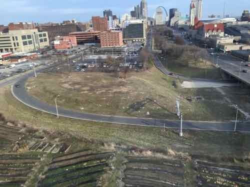
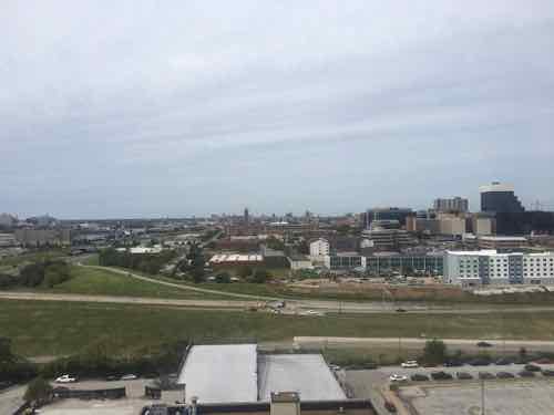
This image is from that February 2016 post, taken from the adjacent hotel.
I haven’t been back to that hotel yet, but I have ridden the St. Louis Wheel at Union Station. Twice, in September 2019 and earlier this month.
Today’s post is a look at similar views from those two visits, nearly 18 months apart.
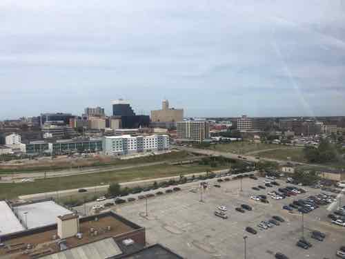
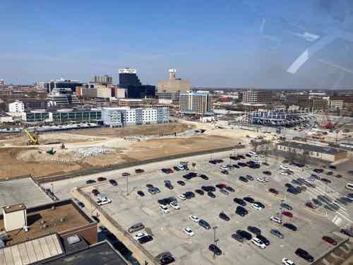
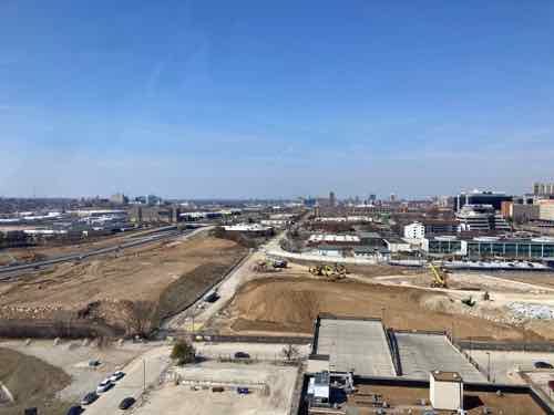
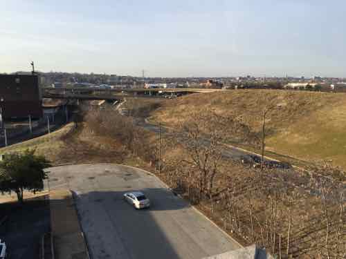
Before: looking northwest on September 24, 2019During: a similar view as above on March 7, 2021. In time the Union Station surface parking lot in the foreground will get developed.
Now for a cropped view focusing on Market over the 22nd Parkway.
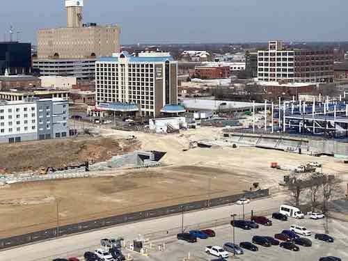
Before: the Market St bridge and the ramp up to it had been there for decades. I saw the big hole on the other side of Market as an architectural advantage.During: the decaying Market Street bridge is gone! The new MLS stadium is set into the hole. A tunnel will provide service access to the stadium.
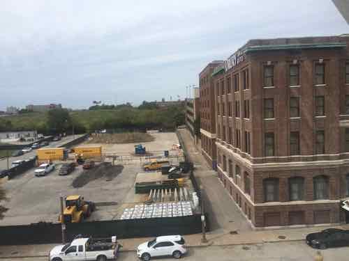
Now looking west:
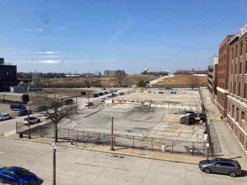
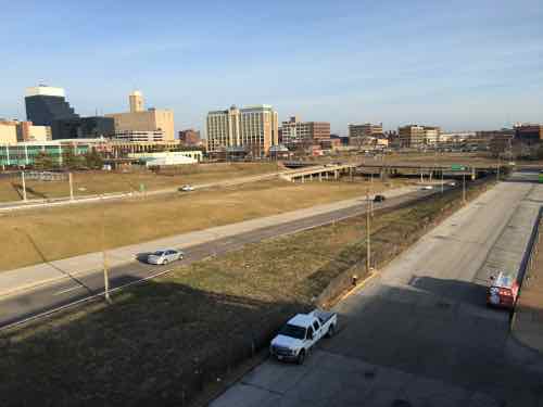
Before: The 22nd Parkway cut a slice between 21st & 22nd streets. Prior NFL & MLS stadium proposals were here, wedged up against I-64.During: for the first time in 6+ decades Clark Ave will be uninterrupted between 20th & Jefferson.
It’s even more exciting closer to street level.
Before: pretty much a dead zone in 2019.During: you can see Clark Ave taking shape. Eventually the long vacant land in the foreground will be developed.
It is very exciting to see this area beginning to recover from the damaging 22nd Street Parkway project. It’ll take years to fill in, but it’s better to naturally fill in over time than to be an all at once infill project.
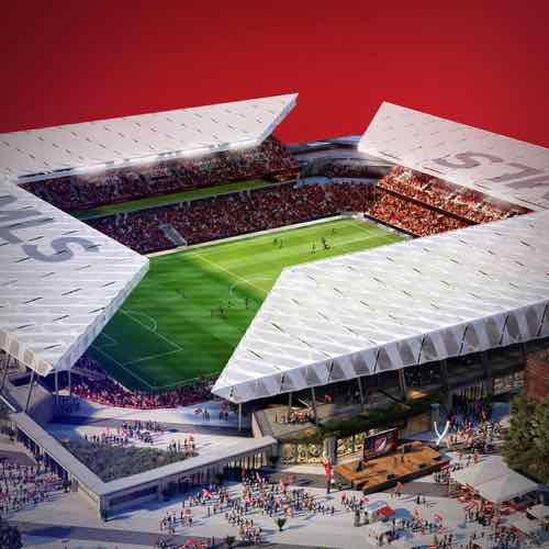
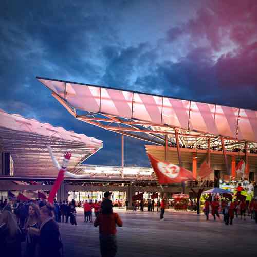
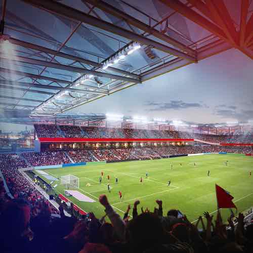
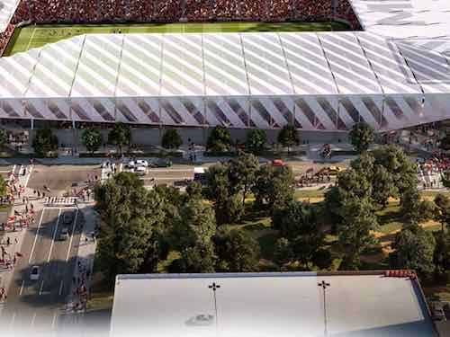
Last week artist renderings were released for a proposed soccer-specific stadium, it’ll be built if the local ownership group becomes an MLS expansion team. The MLS recently approved expanding the league from 28 to 30 teams, so it seems increasingly likely we’ll get an MLS team & stadium. Images from MLS4THELOU
When people see colorful drawings of proposed projects they’ll often get drawn into the images, letting down any critical thinking they might’ve had — they’ve served their purpose of increasing support and reducing criticism. Absent from the documents was a proposed site plan.
Site plans are never sexy, but they help explain relationships between buildings. Without a site plan it’s impossible to fully understand the quality of the design.
I’m very familiar with the area where the proposed stadium would be built. In fact, in February 2016 I posted about it when another ownership group was trying to get a MLS team following the Rams’ return to LA:
The site they shouldn’t consider is the North riverfront one previously targeted for a significantly larger NFL stadium — we shouldn’t tear down buildings when we have vacant land available. We have land, mostly state owned, without any buildings and a target for redevelopment for years already. I’m talking about the 22nd Street Interchange area — an area on the West side of downtown I’ve written about numerous times over the 11+ years.
The state-owned land is the remnants of what was to be a 1950s West loop around downtown.
The second portion of the Distributor Freeway includes ramps from Interstate 64 & U.S. 40 north to Pine Street at 20th Street. This includes short roadways from the Market Street overpass south to I-64. Plans coinciding with the construction of Truman Parkway included the 22nd Street Parkway. Officially cancelled in October 2003, the four-lane parkway was a version of the late 1950s North South Distributor Freeway running north from U.S. 40 to Dr. Martin Luther King, Jr. Drive. The project included the reconfiguring of the interchange with I-64 & U.S. 40 and required condemnation of land north of Pine Street. Increasing costs associated with acquiring land needed for the parkway ultimately led to its demise. (Source)
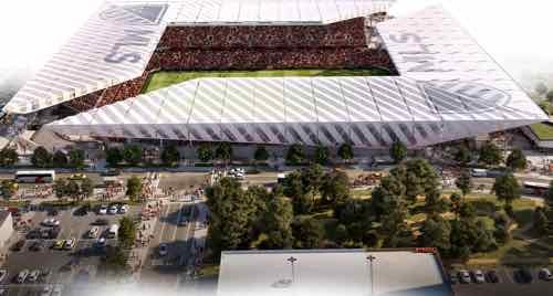
The 4th of the above images is the only one that might give us a clue about the site. Let’s take a closer look.
The top of a parking garage is shown at the bottom.
This garage is either an inaccurate representation of the garage attached to the Drury Inn at Union Station, located in the old railway YMCA, or a new garage. Here are a couple of views from 2016 looking at the proposed site.
Looking southwest, 21st & Clark with an I-64 off ramp behind itLooking northwest, that’s 21st Street on the right
Here’s what I think about the site, both north & south of Market Street:
The stadium & new buildings should take advantage of the existing hole for basement or underground parking.
Market Street between 20th & 21st is a deteriorating bridge, it should be removed. Under it can be filled in with foam so a new road/sidewalks can be built at grade.
Market Street should be redesigned to be friendly to pedestrians. This means narrowing the road (fewer, narrower lanes) and more crossing points. Right now there’s a crosswalk at 20th and at Jefferson –this is nearly a half a mile without a crossing.
Hopefully the changes at Union Station, including the upcoming Farris Wheel along 20th Street, will mean easier access under the train shed between the Union Station MetroLink platform on the East side of 18th to the new MLS stadium.
Metro will need to rethink downtown circulation with a revised Union Station, a MLS stadium, and hopefully active surroundings.
Pine & Chestnut have been a one-way couplet for decades. Once the on/off ramps to/from I-64 are gone both streets should be returned to two-way traffic. The revised Soldiers Memorial, however, has only one eastbound lane on Chestnut between 13th-14th. Chestnut has our only protected bike lane.
I’ll probably think of more issues, hopefully the site planning being done now will address at least some of these.
Over the last year or so the ramps on & off I-64 (Hwy 40) at 22nd have been closed as MoDOT makes repairs to infrastructure. Paul McKee’s plans for this area called for a nice boulevard and new on/off ramps at the highway. I don’t think the ramps are needed at all. See aerial.
ABOVE: Ramp from westbound Pine St onto the 22nd Street interchange leading to I-64/Hwy 40
I use 22nd to get on and off the highway but taking Jefferson Ave is no big deal, I’ve had to do so often over the last 12-18 months when the ramps have been closed.
ABOVE: Only part of a planned highway loop around downtown was built, a huge waste of land to the west of Union Station.
The Jefferson Ave overpass and exits should be rebuilt. Right now on/off ramps only serve the interstate west of Jefferson. I’d add ramps to serve the interstate east of Jefferson and create a single point intersection. Rather than maintaining this little used, little needed infrastructure the land could be developed.
Such a development could make Union Station part of a new neighborhood of offices and apartments.
I’ll have a full report next week on McEagle Developments vision for North St. Louis but I wanted to put out one tidbit today. They indicated a desire to create four job centers where large companies could relocate. One of the four is currently the site of a highway interchange for a highway that was never built, the 22nd street interchange for the 22nd street parkway that was to go around the West edge of downtown. That was the vision in the early 20th Century. The highway has been dead for years but the interchange at I-64/highway 40 exists. I fully support reclaiming this land. I talked about the idea several years ago when reviewing ideas for the West end of the Gateway Mall. I last blogged about the idea in December 2008 in the post MoDOT Needs To Put The 22nd Street Interchange On Any Wish List For Funding. So go back and read that post & comments again so you’ll be up to speed when I mention it again next week as part of my review of Paul McKee’s plan for St. Louis’ North Side.
Since at least the 1930s the planners and traffic engineers that successfully destroyed much of St Louis in the name of progress have envisioned yet another highway in downtown St Louis. It was known as the 22nd Street Parkway and it was to connect hwy 40 on the South and I-70 on the North. The only part that got built was the connection to I-64/Hwy 40.
Thankfully none of the rest got built and the plans to build it have been scrapped.
For a while now MoDOT has been looking at simplifying the interchange to reduce the amount of land consumed — freeing up land to be redeveloped (see MoDOT’s page the interchange). The problem has been a lack of priority in funding the project of reclaiming this wasteland.
The interchange and much around it are the driver’s paradise and the pedestrian’s hell:
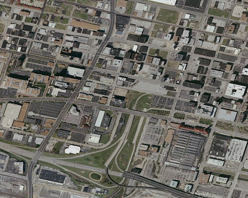
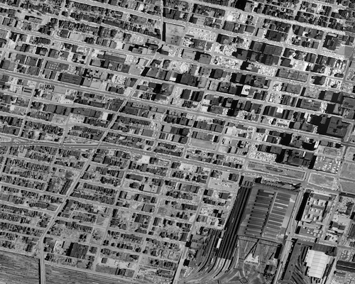
2006 Aerial showing Union Station in the lower right corner and the wasted space of the 22nd Street Interchange to the left of Union Station.
A half century ago the area looked and functioned quite differently:
1958 aerial image of exact same area as shown above.
Both images were purchased from Historic Aerials. To see larger images click either one to view them in Flikr where you can select a larger size.
We need to use this as a model for the future — not to replicate the buildings, but the finely woven street grid.
The 22nd Street Interchange, part of an abandoned highway concept from a few decades ago, needs to be ripped out with the land returned to active tax-paying use. The Missouri Dept of Transportation (MoDOT) should rework the interchange at Jefferson Ave to allow for on/off ramps in both directions and therefore eliminating the need for the current ramps at 22nd. MoDot could sell the land to fund the revisions to the highway ramps.
I picture a new bridge at I-64/40 and Jefferson Ave — one with a single point urban interchange (SPUI) and both East & West on/off ramps. Build that and then remove the 22nd interchange completely. Bring in form-based zoning codes to require a denser urban environment. Make a strong connection through the back of Union Station (between the shed & highway) so that pedestrians from this newly developable land have the opportunity to walk to Metrolink and the 14th street transit station beyond that. The fact that much of this area is already excavated and free of utility lines would simplify the construction of underground parking in new buildings.
If Missouri is asking the new Obama administration to help fund infrastructure this should be near the top of the list. I’m going to suggest that Ald Kacie Triplett (D-6th Ward) put this on the front burner as a way to kickstart the redevelopment of this area.
Such a project could be a huge boon for the city. The impact would certainly be felt beyond the immediate area. For example, Chestnut & Pine could both be returned to two-way traffic. Union Station could once again have an adjacent neighborhood.
A downtown streetcar circulator loop could connect this new neighborhood to the other parts of downtown. With such a large open area it would be the perfect spot for an urban Target store — picture the Hampton & Chippewa store (underground parking) except without the surface parking out front. Retailers that would prefer new construction over squeezing in a historic building would love the location. Building heights of 3-5 floors would give a nice scale although I would not propose any maximum.
St Louis has much rebuilding to do. We’ve got to roll up our collective sleeves and get busy. The current economic situation will improve in a few years and when it does we need to have the new streets in the works and the zoning in place.
AARP Livibility Index
The Livability Index scores neighborhoods and communities across the U.S. for the services and amenities that impact your life the most
Built St. Louis
historic architecture of St. Louis, Missouri – mourning the losses, celebrating the survivors.
Geo St. Louis
a guide to geospatial data about the City of St. Louis