Home » St. Charles County » Recent Articles:

Rapid Urbanization of Dardenne Creek Watershed in St. Charles County Has Dramatically Increased Runoff

From a MoDOT camera, trucks in lower right used to close I-70

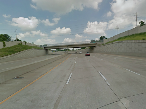
Record rainfall has resulted in flooding in the region, notably St. Charles County. On Sunday a major interstate highway was closed in both directions:

Both directions of Interstate 70 remain closed in St Charles County near Route 79 in St Peters due to rising flood waters from the Dardenne Creek. The eastbound lanes closed around noon Sunday, December 27 and the westbound lanes closed around 2:30 p.m.

It is expected that both the eastbound and westbound lanes will remain closed for Monday morning rush hour traffic.

Motorists who need to use eastbound I-70 in St Charles County can exit at Interstate 64 eastbound to Route 364 eastbound. Route 364 connects to Interstate 270 in St. Louis County and from there motorists can reconnect to Interstate 70. Westbound I-70 travelers will have to exit the highway at Route 94 in St Charles. They can take westbound Route 94 to westbound I-64 to connect back to I-70. (MoDOT)

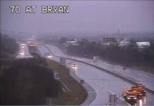
The Dardenne Creek watershed flooded onto the interstate:

A watershed is an area of land where the runoff from rain or snow will ultimately drain to a particular stream, river, wetland or other body of water. There are nine major watersheds in the St. Louis region which drain into the Mississippi River and the Missouri River. Nested within these watersheds can be found smaller watersheds of creeks or streams and those segments of land which drain directly into the nine major watersheds. The following sections delineate the watersheds in the St. Louis region, discuss watersheds and watershed based natural resource planning and describe the actions the general public and local governments can take to improve water quality in their watersheds. (East-West Gateway Council of Governments)

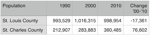
While the record rainfall is big factor in the flooding, we can’t continue to ignore the role of urbanization plays. The better term, however, is suburbanization. Low density development with lots of rooftops, parking lots, and wide roads to connect it all. Coupled with dramatic population growth, too much of the county is paved over.

Here is the population of St. Charles County, per decade, with the percentage of growth from the previous.

  • 1910 24,695 0.9%
  • 1920 22,828 ?7.6%
  • 1930 24,354 6.7%
  • 1940 25,562 5.0%
  • 1950 29,834 16.7%
  • 1960 52,970 77.5%
  • 1970 92,954 75.5%
  • 1980 144,107 55.0%
  • 1990 212,907 47.7%
  • 2000 283,883 33.3%
  • 2010 360,485 27.0%

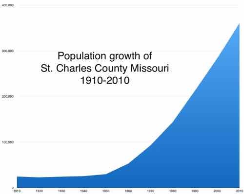
Below is the visual:

Graph made from figures on Wikipedia, click image to view page.

Flooding is an unintended consequence of this growth — all those parking lots add up! Had they planned development to be more compact and respectful of the watershed the current flooding wouldn’t be as extreme. Two geography students looked at this in a paper published in 2009: IMPACTS OF URBANIZATION ON SURFACE RUNOFF OF THE DARDENNE CREEK WATERSHED, ST. CHARLES COUNTY, MISSOURI.

Some quotes:

Urbanization, a common land use/land cover (LULC) change in suburban areas, has become a significant environmental concern in the United States. Urban areas are continuously increasing at an alarming rate (22.7 ha per hour in 1982–1997) as reported by the U.S. Environmental Protection Agency (EPA) (USEPA, 2009). Although it provides enormous social and economic benefits, urbanization creates a significant amount of impervious surface by converting vast area of croplands, for- ests, grasslands, and wetlands into urban uses. The conversion alters natural hydro- logic processes and results in profound environmental consequences within a watershed, such as increasing the volume and rate of surface runoff and reducing ground water recharge (Carter, 1961; Andersen, 1970; Lazaro, 1990; Moscrip and Montgomery, 1997; Tang et al., 2005). Expanded impervious cover also reduces runoff lag time and increases the peak discharge of stream flow, resulting in larger and more frequent incidents of flooding (Field et al., 1982; Hall, 1984) and subse- quent increases in the scouring and incision of streams (Leopold, 1973; Booth, 1990; Doyle et al., 2000). Furthermore, the increase of impervious surface area degrades water quality of the stream, which is a major transporter and concentrator of pollutants (such as nutrients, heavy metals, and pesticides) in runoff and sedi- ments (Schueler, 1995). Percent impervious surface area in a watershed has been used as an important indicator of the ecological and environmental conditions of an aquatic system (Schueler, 1995; Arnold and Gibbons, 1996).

The Dardenne Creek watershed in St. Charles County, a suburb of St. Louis, Missouri, has experienced significant urban expansion in past decades. Events such as road overtopping in 2005 as a result of the highest flood level recorded since stream gages were installed in 1999 (U.S. Army Corps of Engineers, 2007) have focused public attention on the need to understand how the pattern and magnitude of past LULC change have impacted runoff, and how future development and miti- gation might change watershed hydrology. The aim of the work reported here was to provide a quantitative assessment of the impact of past urbanization on surface runoff, and a baseline calibrated model for future efforts to assess potential hydro- logical impacts of new urban development and LULC change.

In the lower portion of the watershed, both forests and agricultural lands decreased from 1982 to 2003, although the rate of decrease became lower after 1987. Corresponding to the decrease of these two LULC classes, urbanization was apparent between 1982 and 2003. In 1982, urban areas only covered 7.4% of the area. After that, they increased at approximately 2.1% per year and became one of the dominant classes in 2003 (50.5%) (Figs. 3B and 3D). LULC change in the upper portion of the watershed was less dramatic (Figs. 3C and 3D) because of its remote location from the metropolitan area. Forest cover in the upper portion was higher than in the lower portion. Forest cover decreased 11.2% from 1982 to 1987 and tended to be stable in the following years. Different from the lower portion, agricultural lands increased from 1982 to 1991, a possible correspondence of deforestation. Agricultural lands decreased after 1991 at a much lower rate than that in the lower portion. Urbanization in the upper portion was limited. Urban areas were only 0.4% in 1982 and gradually increased to 10.9% in 2003. 

Results indicated that the watershed experienced rapid urbanization from 1982 to 2003. Urban areas increased from 3.4% in 1982 to 27.3% in 2003 in the whole watershed. Urbanization dominated in the lower portion of the watershed and gradually migrated to the upper watershed due to the proximity to the metropolitan area of the city of St. Louis. As a direct result of the urbanization from 1982 to 2003, the long-term surface runoff increased >70% for the whole watershed (>95% and >48% in the lower and upper portion of the watershed, respectively). The runoff increase was highly correlated with the percentage of urban areas (R2 > 0.90). Cou- pled with significant flooding events in 1993 and 2005, this work helps raise aware- ness of the actual scale of hydrologic impacts of urbanization in this particular watershed, and provides a simple calibrated tool for local planners to use in assess- ing potential impacts of future development and mitigation activities. More generally, such case studies provide important insight both into the scale of impact of complex land-use change and into approaches that can be used to evaluate, plan, and manage watersheds.

So what can be done about it now, isn’t it too late? No!

I’ve talked about Retrofitting Suburbia before. Architect Ellen Dunham-Jones suggests, in her TED talk, we can daylight creeks, rebuild wetlands, etc.  The solution is to literally urbanize some suburbanized areas, while returning others to rural, wetlands.

However, I seriously doubt the conservative electorate in St. Charles County is willing to do what is necessary. Flooding will likely continue.

— Steve Patterson


Page Avenue Extension (Route 364) Opened Ten Years Ago Today

For years it was just a controversial highway proposal, but a decade ago phase one of the Page Ave. Extension (aka I- Route 364) opened, connecting the Westport area of St. Louis County to St. Charles County.  Years before the opening I participated in efforts to derail the project, including attempting to pursuede St. Louis County voters to reject a land swap allowing the road project to cut through Creve Coeur Lake Memorial Park. Originally planned in 1969, construction began in 1997.

Looking west on I-364 Source: Google Streetview
Looking west on I-364
Source: Google Streetview

Before construction could begin a land swap had to take place to permit the selected route through the south edge of the park:

Opponents say the extension not only will destroy the park but also will add a fourth bridge to hasten the exodus of the middle class from St. Louis and aging St. Louis County suburbs to the greener pastures of St. Charles, Lincoln and Warren counties.

“If it goes through, it’s the turning point for the downslide of St. Louis County,” said state Rep. Joan Bray, D-University City, who helped a group called Taxpayers Against Page Freeway gather more than 40,000 signatures to put the referendum before voters.

Bray said the money slated for the project would be better spent to upgrade existing roads and to expand MetroLink. (source)

Voters, unfortunately, 60% approved the measure in November 1998. Highway advocates spent $800,000 vs $160,00 from the opposition (source).

Following the opening, St. Louis County experienced a population decline for the first time since St. Louis City left in 1876

Many factors are at play in the population decline of St. Louis County and increase in St. Charles County but I have no doubt I-Route 364 played a role.  Ground was broken on the third and final phase on May 22, 2013.

— Steve Patterson


Urbanizing A 1980s Suburban Municipality Is A Lengthy Process

In April 2007 the St. Charles County municipality of Dardenne Prairie held a design charrette led by new urbanist firm DPZ, the goal was to plan a walkable town center.  Dardenne Prairie was incorporated in 1983 and they wanted a town center? Were they crazy? I attended several of the charrette events to observe the process.

ABOVE: Residents at the opening of the charrette in April 2007

Many of the residents attended came ready to oppose anything different than the standard suburbia typical of St. Charles County.

ABOVE: DPZ staff & consultants talking with residents
ABOVE: Sketch for a new city hall to replace the trailer they used

Over the few days I witnessed the local residents buy into the urban/walkable vision. Not urban as in high rise buildings but buildings defining the streets and connected via sidewalks. Urban as in not suburban. In 2009 the city hall was finished but I didn’t get out there until earlier this month.

ABOVE: Dardenne Prairie's city hall, click image for aerial in Google Maps
ABOVE: Hanley Rd will soon have on-street parking

When I arrived I briefly chatted with Mayor Pam Fogarty, but I’d arranged to meet my friend Alderman Scott Kolbe for a tour.  Dardenne Prairie has three wards with two aldermen per ward for a total of six. These municipal offices are non-partisan. Buildings near the road and on-street parking are all part of Dardenne Prairie’s new urbanist City Plan.

ABOVE: Ald Scott Kolbe talks about the park behind city hall from the mayor's balcony

While city hall opened in 2009 the park opened in September 2011.

ABOVE: View of park from the mayor's balcony
ABOVE: On the weekday afternoon I visited the playground area was filled with kids and their parents

Kolbe tells me residents of the subdivision directly behind the park welcome the activity and encourage people to trespass through their yards to reach the park. I can imagine a paved path in the future. As I left city hall people were walking to city hall. If you connect the dots people will, at least on nice days, walk rather than drive.The sidewalk has to replace the roadside drainage ditch for that to happen. Down the street a senior housing development conforms to the new city plan, built up to the sidewalk with a pedestrian entrance facing the street.

ABOVE:

It will be years before Dardenne Prairie has a complete walkable downtown but they are putting the right pieces in place to make sure each new private development contributes toward the long-term vision. – Steve Patterson


Poll: Would You Support A 3/16¢ Parks/Arch Sales Tax Increase

ABOVE: The final piece of the Gateway Arch was set into place on Thursday October 28, 1965

In November voters in St. Louis, St. Louis County and St. Charles County may be asked to approve a 3/16¢ sales tax increase:

An obscure bill moving through the Legislature includes a provision that would allow residents to vote — possibly in November — on raising sales taxes in St. Louis, St. Louis County and St. Charles County by three-sixteenths of a cent (0.1875) for the Arch project and other area parks. (STLtoday.com)

The CityArchRiver group and Civic Progress say the sales tax revenue is needed to pay off bonds to complete planned improvements to better connect the Arch to the city. Much of the money would fund parks in each taxing jurisdiction:

Susan Trautman with the Greenway District says only 30 percent of the tax would go to the Archgrounds. The rest would go towards improving local and regional parks and trails.

[snip]

The tax increase would only last 20 years and collect enough money to pay for a $120 million bond issue to help pay for the project. (KMOV)

Voters in Illinois may also be asked to support a small tax increase as well. This is the subject for the poll this week — the poll is located in the right sidebar.

– Steve Patterson


St. Charles County Executive Steve Ehlmann Vetoed Smoke-Free Bill

St. Charles County Executive Steve Ehlmann

Yesterday St. Charles County Executive Steve Ehlmann vetoed a bill that would have given voters the opportunity to decide if they wanted their county to go smoke-free. In the poll last week the single answer with the most was the one where he would sign the bill and voters would approve:

Q: When Will St. Charles County Go Smoke-Free?

  1. Ehlmann will sign bill and voters will approve it in Nov 2012 16 [32%]
  2. Only after a statewide ban 13 [26%]
  3. Never 8 [16%]
  4. Other answer… 4 [8%]
  5. Eventually, Ehlmann will sign bill but voters won’t approve it in Nov 2012 3 [6%]
  6. Eventually, Ehlmann will veto this bill but this change will come later 3 [6%]
  7. Ehlmann will veto this bill but the County Council will override, voters approve in Nov 2012 2 [4%]
  8. Ehlmann will veto this bill but the County Council will override, voters reject in Nov 2012 1 [2%]

The issue was the casino exemption:

“If the purpose of the smoking ban is to protect the health of employees, there is no rational reason to exclude casino floor workers,” the Republican executive said in his veto message.

“If tobacco smoke is harmful, there is no reason to exempt cigar bars, while regulating bars that allow cigarette smoking.” (source)

The other answers were:

  1. How should I know?
  2. Who cares, St Charles county is a worthless pile of crap
  3. Why ban a legal product? Heavy perfume makes me ill…ban overly scented people
  4. I feel that speculating over what will happen is kind of pointless.

My reason for the poll was to show regional interest in going smoke-free.  Maybe there isn’t such interest? Expect additional bills to bring this to voters, most likely without an exemption for casinos.

– Steve Patterson


Advertisement


[custom-facebook-feed]

Archives

Categories

Advertisement


Subscribe