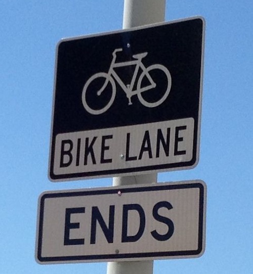
Bike lanes, when done right, can greatly assist the users by guiding them and making motorists more aware. Done wrong, the cyclist often ends up in the wrong position at an intersection. Most of the time in St. Louis our bike lanes are flawed, especially at intersections.
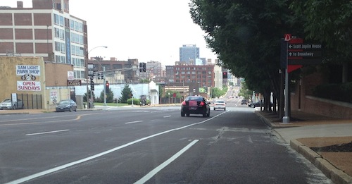
Sign posted on westbound Lafayette Ave just before Jefferson Ave.Eastbound on Olive just before Jefferson the bike lane becomes part of the right turn lane
In the situations above most people on bikes will incorrectly shift to the right so they’ll be to the right of right turning vehicles — not good for the cyclists or motorists. Bikes are vehicles so those continuing straight through the intersection need to be positioned to do that. Above, that means being on the white line separating the through lane from the right turn lane.
In cities where they do more than lip service bike lanes are more helpful.
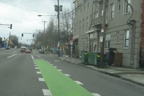
The places where cars are allowed to cross bike lanes for right turns are very clear in Portland OR. 2009 photo
In the above example from Portland, even the most amateur cyclist will stay in the proper position on the roadway to continue forward. Motorists will be able to get into the right turn lane and turn without conflicting with the cyclist.
Colored bike lanes have been a feature of bicycle infrastructure in the Netherlands (red), Denmark (blue), France (green) and many other countries for many years. In the United Kingdom, both red and green pigments are used to delineate bike lanes and bike boxes. However, in this country their use has been limited to a few experiments in just a handful of locations. The most extensive trial took place in Portland, Ore., where a number of critical intersections had blue bike lanes marked through them and the results were carefully monitored. The results of the study, conducted by the City of Portland Office of Transportation and the UNC Highway Safety Research Center, can be found here.
The Portland photo was taken about a decade after their study. Portland cyclists must still be skilled to be able to make left turns, for example.
The St. Louis region ranks second in the nation for fragmentation of government, resulting in negative consequences:
With each decennial Census since 1980, we find that more people are leaving the St. Louis region than moving in. We rank very low among competing metropolitan areas in job growth and in new business starts. We have not attracted the new immigrants that other metros have done in recent decades, and our demographic profile is much less diverse than that of regions that are growing. Economic and racial disparities create chasms within the regional family. Our governmental structure is second in the nation in terms of fragmentation. (East West Gateway)
Not good, right? Often cited is the 90+ municipalities in St. Louis County but last week I discovered a small example of governmental fragmentation within the City of St. Louis.
A parking meter issue related to the Central Library was voted on by the Parking Commission last week that required me to dig into St. Louis’ history from 156+ years ago to get some answers. Huh? Yes, I had to go back to two land transactions from 1857 to try to make sense of a modern day issue. I’m still not totally clear about the legality of a recent property boundary adjustment, but first let me set up the background for you.
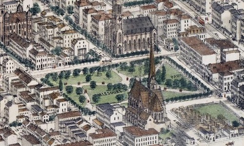
The 1875 Compton & Dry map shows the park 8 years before the St. Louis Exposition and Music Hall was built on the block.
We need to start with the history of the land bounded by Olive, 14th, St. Charles St., and 13th — today the site of the Central Library and Lucas Park. The old city website about Lucas Park had great information, good thing I saved it before it was removed:
Lucas Garden was the site of a brick house built by Judge Lucas in 1820 facing the present St. Charles Street or King’s Road, as it was called. There is still a flowing spring in the Public Library basement that was the water supply for the Judge’s home.
“Desirous of contributing to the ornament and health of the City of St. Louis and at the same time to establish a permanent monument to the memory of his ancestor (father) the late Honorable John B. C. Lucas, in the shape of a public square bearing his name,” reads the deed signed by James H. and Marie E. Lucas on March 24, 1857, giving the block of land immediately north of the St. Louis Public Library to St. Louisians. The deed states further that, “This conveyance is however made with the express condition, to wit: that said public square shall forever be maintained as a public promenade for the inhabitants of the City of St. Louis.”
On the same day in 1857 that he signed the deed on Lucas Garden, James H. Lucas sold the block where the Public Library now stands to the city for the sum of $95,000.
In 1859, a board of improvement for the park was created and its development started.
Its layout caused Locust Street to be closed at 13th and the park was given an asymmetrical plan with a bandstand near the foot of Lucas Place. Sale of the buildings at the southwest corner of the park was authorized by Ordinance in 1872. From the time of the first appropriation in 1858 to 1877, $41,465 was spent on it.
The entire 6.25 acres was named Missouri Park and provided popular downtown breathing space until the erection of the St. Louis Exposition and Music Hall in 1883. Licensed to a private corporation for a period of 50 years, the ground was restored to use as a park in 1907 and designs for the Italian Renaissance inspired library building were drawn up by the famous architect Cass Gilbert. The library was completed in 1912.
Locust Street was reopened behind the Library from 13th to 14th Streets and the present sunken garden with its fountain was developed. (source)
So the city bought the block where the library stands, but the land for the park to the north was a gift to the city, with conditions. With both parcels part being public land there shouldn’t an issue over boundaries. Shouldn’t, but there is.
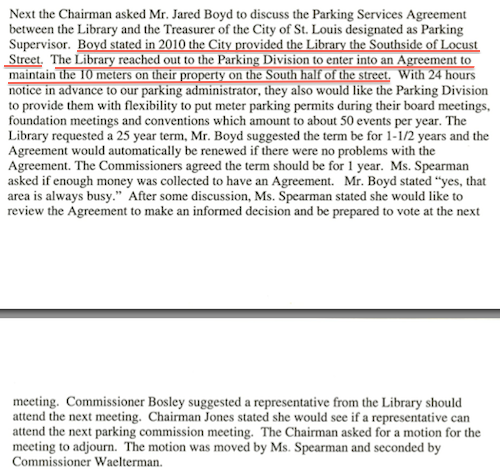
The city provided part of Locust St to the library, so the library wanted negotiate the parking meters on their property? Parking Commission minutes from the June meeting, click image for 4-page PDF.
“Their property?” The city “provided” land presumably part of the 1857 grant to the city to the public library, which then generously allowed the Treasurer’s office to keep parking meters located on the new moved sidewalk. Could citizens stage a protest on this sidewalk or would the library tell citizens it isn’t public property?
At the July meeting of the Parking Commission they voted to allow the library to “hood” the ten meters on library property up to 50 times per year for special events, including board meetings.
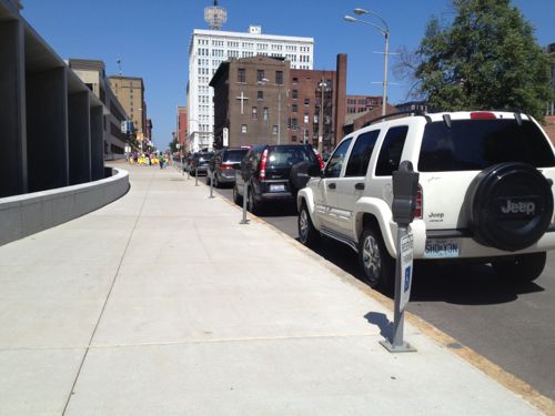
These meters are apparently on library property just gifted from the city
The next day I emailed all involved, informing them the library neglected to mention that two of the ten spaces are designated as disabled parking. Even if the parking meter is hooded, anyone parking in the space needs a legit disabled placard or plates. You can be sure I’ll be watching to see. Even so, I don’t like the idea of a disabled patron driving down to the library only to find every space on this side of the street taken by the library for board members.
When I first moved to St. Louis in 1990 my first apartment was on Lindell at Euclid Ave. At the time Euclid Ave was the most urban street in St. Louis with shops (remember Heffalumps?) and restaurants. One of my first jobs was at an antique store east of Jefferson, not much positive was happening west of Jefferson except prostitution. Not long after I made my first trip to Crown Candy — at night. The 14th Street Pedestrian Mall seemed totally dead.
Today we have many thriving commercial streets, amazing progress is just two decades. The poll this week asks you to pick your favorite of these, here are the choices I’ve provided:
N. 14th St. (Old North)
Cherokee St.
Delmar (Loop)
Euclid (CWE)
Grand (South Grand)
Locust St (Midtown Alley)
Manchester Rd Ave (The Grove)
Morgan Ford
Washington Ave
If you think of another you can vote for it in the poll using the other field. The poll is in the right sidebar (desktop layout).
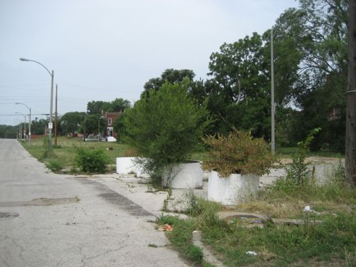
Vince Schoemehl served as mayor for three 4-year terms, from 1981-1993. He’ll be remembered in history for a number of things, but perhaps mostly for giving us “Schoemehl Pots,” concrete sewer pipe sections filled with dirt.
Schoemehl pots used in their traditional role of messing up the street grid. N 22nd St & Newhouse Ave, click to view in Google Maps
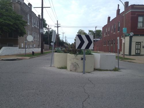
Lately they’ve been used in a way that calms traffic while keeping the grid intact: the Schoemehl Pot Roundabout Traffic Circle!
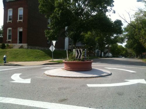
Utah St & Arkansas Ave, click image to view in Google MapsA more permanent traffic circle at Louisiana & Osceola, click image to view in Google Maps
The roundabout traffic circle shown at the bottom takes a considerable investment compared to a few sewer pipes filled with dirt, but the results are dramatically different too. I just know I’ve never seen a Schoemehl pot installation that didn’t make me cringe. Can we stop using them to block streets and create makeshift roundabouts traffic circles?
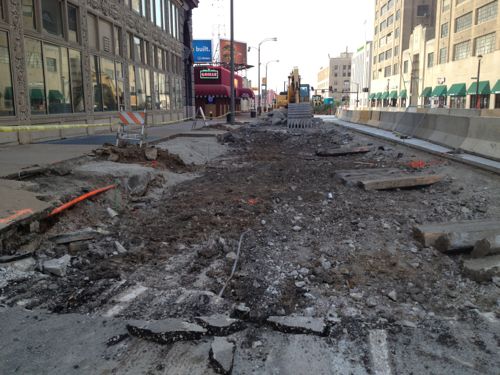
The last bit of the old Tucker Blvd road surface, from Cass to Washington Ave, is now rubble. The last of the former rail tunnel was filled in a couple of months ago, now all that needs to be replaced is the last of the small area that didn’t have a tunnel under the roadway.
Looking north at Tucker Blvd from Washington Ave. This is the last part of the old road surface to be removed.
In addition to the road surface, the adjacent sidewalk for these last couple of blocks. Auto traffic is now open from Cass to Washington Ave in both directions, though constrained on the south end.
AARP Livibility Index
The Livability Index scores neighborhoods and communities across the U.S. for the services and amenities that impact your life the most
Built St. Louis
historic architecture of St. Louis, Missouri – mourning the losses, celebrating the survivors.
Geo St. Louis
a guide to geospatial data about the City of St. Louis
 Today we have many thriving commercial streets, amazing progress is just two decades. The poll this week asks you to pick your favorite of these, here are the choices I’ve provided: