Over the years I’ve been asked how I find things to write about, the answer is always easy: I go places like the grocery store, to dinner, or, yesterday, to buy a gallon of paint.
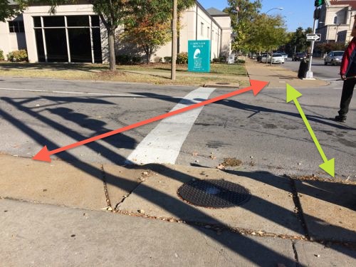
Able-bodied pedestrians follow the green line but those of us in wheelchairs must follow the red
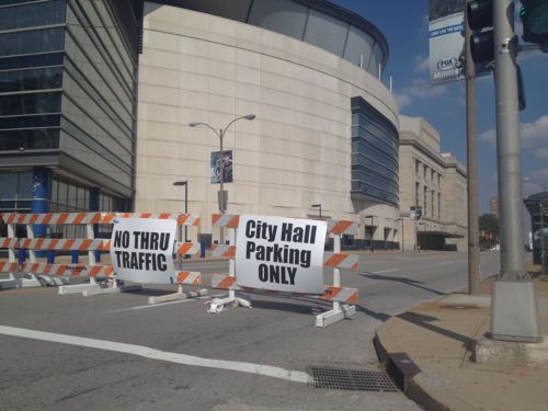
When cars are stopped at the stop line they still block the curb ramp. This is similar to a situation on Magnolia at Grand, I posted about it in 2007 (St. Louis Crosswalk Ignores ADA Ramps). That got fixed quickly by moving the stop line back, but this seems a bit more complex. The sewer inlet and light post (just out of frame) make a ramp a tight fit. Curb bulbs like a few blocks north on Grand would provide the space needed.
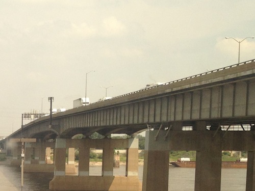
Nicknames tend to stick, for better or worse. The I-64/Hwy 40/I-55 span across the Mississippi River was first known officially as the Bernard F. Dickman Bridge and was recently officially renamed the Congressman William L. Clay Sr. Bridge.
The Poplar Street Bridge over the Mississippi River was completed in 1967
In the unscientific poll last week readers made it clear they’ll continue to call it the Poplar Street Bridge, after the street that was once at that location.
Q: In the future, what do you plan to call the I-55/I-64 span over the Mississippi River?
Poplar Street Bridge 99 [89.19%]
PSB 9 [8.11%]
Bernard F. Dickman Bridge 2 [1.8%]
Congressman William L. Clay Sr. Bridge 1 [0.9%]
Other 0 [0%]
I’m one of the 8% that calls it the PSB. Poplar Street still exists in a few places under the bridge, like at Broadway. Maybe in 45 years it’ll be officially renamed the Francis G. Slay Bridge.
Event areas shouldn’t have curbs! Yes, in most areas curbs are necessary for water flow and keeping cars off sidewalks. Yesterday I posted about a conflict between major events and transit access, primarily at 14th @ Chestnut. Today is about curbs — actually my wish for no curbs when a festival area gets designed in the Gateway Mall.
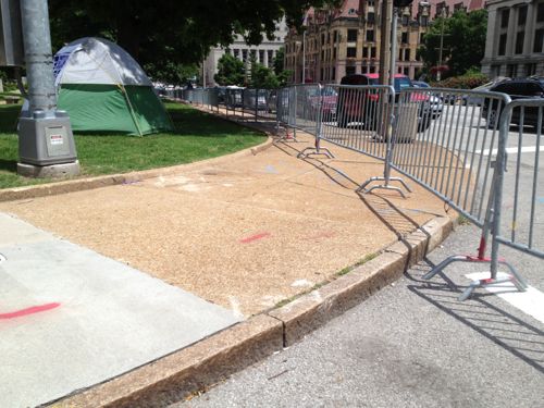
The problem with holding events in an area not designed for events is crowd control and accessibility. Here crowd control blocks access to the curb rampsThe two blocks of Washington Ave feature a mostly curb-free design
When the two blocks of Washington Ave from Tucker to 14th are closed for an event the design doesn’t present accessibility issues.
Of course there are many other issues to consider when designing a festival area: power distribution, lighting, sound, sanitation, etc. Flexibility is important too. Event planners need to be a part of the planning & design process.
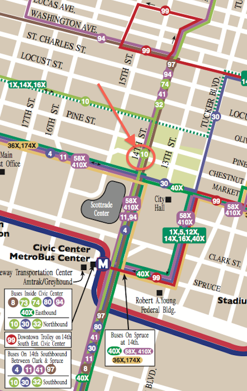
14th Street is a very popular north-south street through downtown St. Louis. Unfortunately, it’s too popular. Nearly every MetroBus that comes into downtown uses 14th just as nearly every event shuts down at least one intersection along 14th, usually at Chestnut, requiring many buses to reroute.
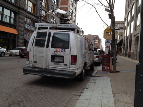
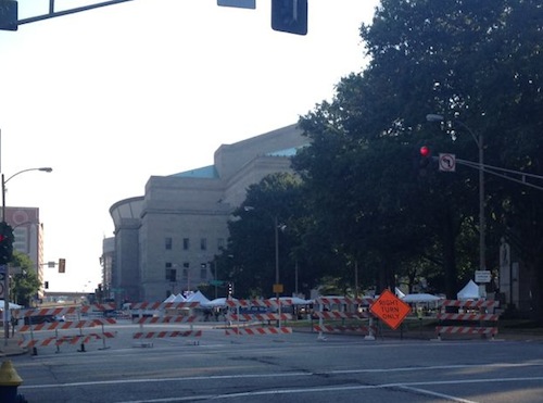
14th Street was closed between Clark & Pine recently for the Taste of St. LouisFrom Metro’s downtown detail map we can see the six bus routes that pass through the 14th & Chestnut intersection: 10, 32, 41, 74, 94, 97. The 4, 11, 30, 58x, 410x use 14th St south of Market14th Street closed at Pine on a thursday morning to set up for a weekend event
It seems like twice per month there’s a festival, concert, run, walk, bike ride, parade, or something that totally screws up the bus routes and schedules. All because the events shut down the primary route used by the buses. Because we’ve messed up our street grid for years by removing streets and making others one-way 14th St is the only choice for these bus routes. The reroutes that go into place are time consuming, making that route late everywhere it travels.
The solution is to remove the conflict, not close 14th St. How you ask? Not possible right now, but perhaps once the area is redesigned.
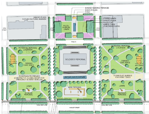
The Gateway Mall Master Plan calls the area around Soldier’s Memorial the “Civic Room”, click image to see section. 14th St separates the left third from the right two thirds+.
From the Master Plan:
The Civic Room will create a large unified space well-suited for civic events, markets, festivals and concerts. In order to achieve this, it is anticipated that Chestnut Street would be closed incrementally over time, beginning with temporary closures for festivals, and ultimately considered for permanent or seasonal closure. though still allowing emergency and service vehicles access. Chestnut Street should be still be hard surfaced with a paving different than surrounding areas, to accommodate tents and other services necessary for festivals. Locations for performance stages and cultural or art annexes should be provided to further define the civic character of the space and create attractions to activate the mall.
This is good, just the wrong location. Rather than Tucker (12th) to 15th I think it needs to be 14th to 17th or 18th. 18th St is a busy street but it doesn’t have any bus routes, close it for an event to combine with Aloe Plaza to 20th. But from 15th to 20th the space is narrow, from Market to Chestnut only.
If the St. Louis Streetcar gets funded and built, 14th St will need to stay open so I hope someone creative can find a way to hold events here while still allowing all transit vehicles continuous access to 14th St.
Transit is important but so are events. One shouldn’t be compromised by the other. Tomorrow’s post will be about design issues with the current area around the Soldier’s Memorial along with some possible solutions.
Next year St. Louis will turn 250 years old. In those early years St. Louis didn’t have a municipal water system, but for the last 178 years we have.
1764: The City of St. Louis is founded. 1831: The City of St. Louis contracts with Abraham Fox and John Wilson to build a waterworks. 1835: The City of St. Louis buys out the bankrupt Fox and Wilson, becoming sole owner of the St. Louis Waterworks. (St. Louis Water history)
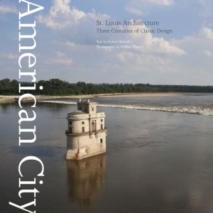
Cover of American City: St. Louis Architecture by Robert Sharoff & William Zbaren features a water inlet on the cover
PROJECT OBJECTIVE: The objective of the St. Louis Water Division is to retain a Consultant or Consultants with expertise in water system operations that can provide insight and new ideas, programs and approaches on ways to increase the Water Division’s efficiency and/or revenues in order to postpone or lessen future water rate increases and to improve customer satisfaction. The Cityand the Water Division for the most part would like to identify the ideas, have them bedeveloped into projects or programs and be implemented through Performance Contracting such that the City has no additional initial outlay of funds for capital projects or procurement of equipment or services. There will be some Non-Performance Contracting efforts that will result in delivery of a report with recommendations and a detailed implementation plan that can be executed by the SLWD or others
Sounds like a proactive step, but the winner of the bidding process, French firm Veolia, is viewed by some as a company that specializes in the privatization of public water systems. So the fear is a short-term consulting contract is the gateway to handing over a valuable city asset.
Mayor Slay is saying Comptroller Green has a duty to sign the $250,000 contract since it went through the bidding process. Meanwhile, Lewis Reed, President of the Board of Aldermen, is calling for hearings over the handling of the contract.
For months a grass-roots organization Dump Veolia has fought the contract at every step:
We are a group of concerned residents who want St. Louis to reject a proposed water consultancy contract with the French multinational corporation Veolia, the largest water privatization company in the world.? Learn what the campaign is about, who is mobilizing against Veolia, and why.???
The poll question this week is “Should St. Louis Sign The Water Consulting Contract With Veoila?” The poll is in the right sidebar, results to be posted on Wednesday October 20th.
AARP Livibility Index
The Livability Index scores neighborhoods and communities across the U.S. for the services and amenities that impact your life the most
Built St. Louis
historic architecture of St. Louis, Missouri – mourning the losses, celebrating the survivors.
Geo St. Louis
a guide to geospatial data about the City of St. Louis