Home » History/Preservation » Recent Articles:

What Will Become of the Historic Former Arsenal Site Once the National Geospatial-Intellegence Agency Relocates?

The battle over where the National Geospatial-Intellegence Agency (NGA) will relocate intensified recently when Illinois Gov. Bruce Rauner stepped late in the game with a bid across the Mississippi River:

St. Clair County has agreed to donate land near Scott Air Force Base and MidAmerica Airport to the combined defense and intelligence agency, which provides mapping support for the U.S. military  and employs 3,000 people locally.

The agency is also considering two sites in St. Louis County and one in north St. Louis as it looks to move from its current location near the Anheuser-Busch brewery in Missouri. (KMOX)

Here’s more about the NGA:

NGA is headquartered in Springfield, Va. and has two major locations in St. Louis and Arnold, Mo. Hundreds of NGA employees serve on support teams at U.S. military, diplomatic and allied locations around the world. (NGA

I’ve questioned the wisdom of the city site from a design viewpoint, see St. Louis’ Low Standards Turns A Once-Proud City Into A Suburban Office Park. Keeping these jobs in the city makes sense financially, though employees who also live in the city will still pay earnings tax.

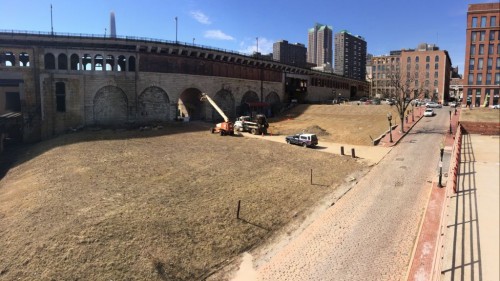
This post, however, isn’t about the new site — it’s about the current site and what will become of it once the NGA relocates.

3200 S. 2nd
NGA, located at 2nd & Arsenal St, as seen from Lyon Park. The grounds include historic 19th century structures and some very large newer structures
I arrived on the #30 MetroBus
I arrived on the #30 MetroBus, the #40 goes by on Broadway
The site is well protected.
The site is well protected, the cannonballs on top of the stone posts pay tribute to the days when this was a federal arsenal  — hence Arsenal St.
A
An employee leaving the site to catch the next bus.

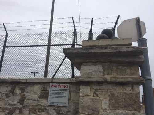
City records don’t list any information about any of the buildings on the site — makes sense since it’s a spy agency located on Air Force property. Thankfully the St. Louis Air Force Station was listed on the National Register of Historic Places in January 1975.

Within the confines of this acreage are ten buildings with erection dates from 1830 to 1906. These buildings are of Federal architecture, and are arranged in such a manner that gives an excellent example of the building prac tices and a remnant layout of a major arsenal of the early 19th Century.

Of particular interest are buildings #4 and #5, which are two of the oldest and best preserved buildings on base. Both are constructed of limestone walls over stone foundations, and their site and architectural integrity has not been altered since they were built in the l830’s. These buildings are built in the Federal style of architecture, which characterizes the majority of the other buildings except buildings 20 and 22 which are of modified Federal architecture. A further exception to this style is evident in building #25, which was constructed in 1906, and is believed to be of modified French Colonial architecture. It should also be noted that building #1 has lost its architectural integrity through extensive modification, but it was of modified Federal architecture before remodeling.

Site alterations have occurred to buildings #12 and #13. Each were originally built as three separate buildings in the form of a “Cross”, but during the early 1920’s, the middle building was removed, rebuilt, and connected in a straight line with the other two buildings. The integrity of the end sections of each building was maintained. Also, building #1 had considerable architectural alteration in January 1963. The building origin ally had three floors, but the second and third floors were rer.ovedj and the first floor was rebuilt. Site integrity was preserved. (St. Louis Air Force Station nomination)

One large multi-story building on the site was built after 1975. What will become of this property once the NGA vacates?

— Steve Patterson


A Lemp Suicide 95 Years Ago Today

Late last month Missouri State Auditor Tom Schweich committed suicide at his home in Clayton.  His was not the first local suicide among those who, by outside appearances, had a lot going fir them.

Foe example, the Lemp family:

In 1870 Lemp was by far the largest brewery in St. Louis and the Lemp family symbolized the city’s wealth and power. Lemp beer controlled the lion’s share of the St. Louis market, a position it held until Prohibition. In 1892 the brewery was incorporated as the William J. Lemp Brewing Co. In 1897 two of the brewing industry’s titans toasted each other when William Lemp’s daughter, Hilda, married Gustav Pabst of the noted Milwaukee brewing family. (Lemp Mansion)

The suicides began in 1904 with the head of the family, William Sr:

Lemp, 68, shot himself on the morning of Feb. 13, 1904, in his second-floor bedroom of the family mansion at 3322 South 13th Street (now DeMenil Place), next to his brewery covering 13 blocks. Lemp had never gotten over the sudden death in 1901 of his son, Frederick, brewery superintendent, from a heart ailment. His depression deepened. When he didn’t emerge from the room that morning, no one took much notice. (Post-Dispatch)

His son, William Jr., took over the brewery. Sales declined and, in 1919, the brewery shut down because of Prohibition.

Lemp Mansion
Lemp Mansion at 3322 Demenil Pl, previously known as S. 13th St, was built in 1860s. It’s over 7,300 sq ft. in size. Click image to see map.

The next suicide I’ve seen listed as March 19th and as March 20th — 1920:

The second in the series of Lemp family suicides was that of Elsa Lemp, daughter of William Lemp (who killed himself in the Lemp Mansion in February 1904) and the younger sister of Billy Lemp, who took over the brewery. She had married Thomas Wright, President of the More-Jones Brass and Metal Company, in 1910 and divorced him in 1919. She was granted the divorce on the same day she filed the request, but almost immediately turned around and remarried him on March 8, 1920. Just a few weeks later, Elsa told her new-old husband that she wanted a quiet night to herself. The following morning, he heard a sharp crack and ran into the bedroom to find she had shot herself. When Billy Lemp arrived at the scene, he was remarked as commenting only “that’s the Lemps for you.” (STL250 via Facebook)

Wow, clearly Elsa, 37, was conflicted. Granted a divorce on the day filed? Remarried less than a year later only to kill yourself 11/12 days later! Her daughter died during birth in 1914.

Here’s the home where the couple lived:

13 Hortense Place
13 Hortense Place, built in 1901, is almost as large at just over 6,500 sq ft

I have the following questions about this house:

  • Who built it in 1901? Her husband Thomas Wright?
  • Or did the couple buy the fairly new home after getting married in 1910?
  • How long did Thomas Wright live in the house after Elsa’s death?

I searched the 1940 Census and found him living nearby at 46 Portland Place with a new wife, Cora, her son, 24 year-old William O’Fallon, and three servants: Dora Six, Emma Light, and Esther Siegerit. This house was 11 years newer, built in 1912; a bit smaller at just under 5,000 sq ft — still large.

Elsa was the youngest of her siblings, she’d just turned 21 when her father committed suicide in 1904. Her brother William, 55, shot himself in the family mansion in 1922 — not long after selling the brewery property. Another brother, Charles, also shot himself in the mansion in 1949 — he was 77 and the last family member to live in the family mansion.  Her sister Hilda Lemp Pabst died, presumably of natural causes, in 1951 at age 74.  The last Lemp sibling, Edwin, died in 1970 at age 90.

Edwin Lemp owned 200 acres adjacent to the Meramec River where he began building his 11,000 sq ft home, Cragwold, in 1911:

Edwin Lemp was born in 1880 and grew up during the time that the American conservation movement was at its height. Being a well educated man, he would have been familiar with the conservation issues of the time and most likely read many of the essays written on the topic. With Lemp’s well-known love of nature and animals, it would be easy to assume that he most likely shared many of the same conservation views as Olmsted, Burroughs, Powell, Muir, and Theodore Roosevelt. Lemp’s well-known love of nature and animals can be traced back to his childhood, when he kept canaries and parrots. As an adult, Lemp’s love of nature would lead him to discover the place where he would build his estate.

About the same time his brother William Jr built the Alswel estate nearby. Neither Charles or Edwin married, Edwin was gay and presumably Charles was as well.

Many Lemps are interred at the Lemp mausoleum in Bellefontaine Cemetery.

— Steve Patterson


Fortieth Anniversary of Laclede’s Landing Redevelopment

Four decades ago today — February 19, 1975 — the Board of Aldermen took at step to save what little remained of the oldest part of the city:

A group of downtown bankers and businessmen, led by William Maritz announced the formation of a corporation to oversee development of the tiny group of remaining buildings along the riverfront levee. The Laclede’s Landing Redevelopment Corporation was approved by the Board of Aldermen, which allowed interested owners to retain and improve their properties. Through the 1960’s several proposals were put forth for the area, including one shortsighted suggestion of complete demolition. The area was listed on the National Historic Register in 1976, the first commercial district in St. Louis to do so. Laclede’s Landing has since been on a steady upward path, with several local architects contributing to its renovation. The name “Laclede’s Landing” is a relatively recent name that has been given to the site, as there were nearly 150 more blocks of a similar character that made up the St. Louis riverfront before the creation of the Jefferson National Expansion Memorial. (STL250 via Facebook)

The bulk of the original city had been razed 35+ years before to make room for a riverfront memorial — eventually the Arch we know today. In 1975 the Arch was open but the grounds not yet landscaped, the north garage not yet built.

In the last four decades the area hasn’t been stagnant, buildings have been renovated while others have been lost. Most recently some sidewalks were improved, made more accessible.

Workers rebuilding curbs & sidewalks along N. 2nd St, November 2013.
One of the new sidewalks along N. 2nd, November 2014
It was announced a park was planned for the north side of the Eads Bridge, to the right of the trucks parked in the alley,
A park is planned for the site where the Switzer building collapsed (north side of the Eads Bridge, to the right of the trucks parked in the alley) March 2014 photo.

Despite recent progress, this summer a big employer will leave Laclede’s Landing:

Following an extensive search, the Bi-State Development Agency (BSDA) is excited to announce the relocation of its headquarters to the Metropolitan Square Building at 211 North Broadway in downtown St. Louis. The move is planned for summer 2015.

Since 1982, BSDA has occupied space at 707 North 1st Street, which currently serves as the agency’s headquarters for the Metro transit system, the Gateway Arch tram and ticket operations, St. Louis Downtown Airport, the new St. Louis Gateway Freight District, and the Gateway Arch Riverboats. The 117-year old building has approximately 100,000 square feet of floor space. (NextStopSTL)

Links:

Hopefully other businesses will take over the space that’ll be vacated by Metro! I’m grateful that decades ago some saw the value of holding on the last remnants of the old city.

— Steve Patterson


Arch Construction Started 52 Years Ago Today

February 12, 2015 Downtown, Featured, History/Preservation Comments Off on Arch Construction Started 52 Years Ago Today

After more than two decades as a vacant site, work on a Jefferson Westward Memorial was finally started 52 years ago today.

ABOVE: Slope down to the north below grade museum entrance.
The Gateway Arch.

At the beginning of the 20th century our leaders wanted to raze the historic riverfront and pay tribute to the Louisiana Purchase.  In October comes the 50th anniversary of the final piece of the Arch being lowered into place. It’ll be a few more years before we can celebrate the half century mark of being able to visit the top of the Arch.

— Steve Patterson


The 1876 City Limits Were So Far Out In The Countryside

From its founding in 1764 the city limits of St. Louis kept expanding as the city grew in population. Each time they annexed land in the rural fields surrounding the city.

The 1860 census recorded 160,773 residents — more than 100% growth from 1850s census figure of 77,860. The 1870 census saw the population nearly double again — to 310,864 (Wikipedia). When St. Louis divorced itself from St. Louis County in 1876 the limits where set far out in the countryside.  The leaders at the time must not have thought we’d reach those limits as quickly as we did, or leapfrog them as happened.

This marker at the St. Louis-Maplewood city limits is where
Entering St. Louis from Maplewood, where Manchester Rd becomes Manchester Ave

Though Maplewood wasn’t incorporated until the 20th century, people like James Sutton settled the area in the early 19th century decades before St. Louis split with St. Louis County.  From Maplewood’s history:

In 1876, the limits of the City of St. Louis were extended to their present location. This limit line shows no consideration for the buildings in Maplewood, but ruthlessly bisects many of them. It cuts off the eastern triangle of the Brownson Hotel and runs right through the middle of the old Maplewood Theater, (now gone) putting the projection booth in Maplewood and the screen in St. Louis.

On one street, however, the limits do not interfere with the house. This is along Limit Avenue which was plotted with half of its width on either side of the limits line (St. Louis on the east and Maplewood on the west).

This divorce bought change to the county left behind:

When the new county was organized, a Maplewood man, Henry L. Sutton, son of James C., was chosen as its chief executive officer, or presiding justice of the county court. The first three meetings of this body were held at the Sutton home on Manchester. Then in 1877, the patriarch of the neighborhood, James C. Sutton died. He left nine children and his land was divided between them. One of the daughters, Mary C. Marshall, seems to have been the first to think of selling her tract for a subdivision, for in 1890, she sold to a company organized by Theophile Papin and Louis H. Tontrup, two St. Louis real estate men, and managed by Robert H. Cornell.

If only we could bring the 1870s leaders into the present day to show them the consequences of their actions. If so, St. Louis would likely  be part of St. Louis County with limits out near the present-day I-270.

— Steve Patterson


Advertisement


[custom-facebook-feed]

Archives

Categories

Advertisement


Subscribe