Home » Public Transit » Recent Articles:

Year anniversary of Gateway Transportation Center

November 21, 2009 Downtown, Public Transit 6 Comments

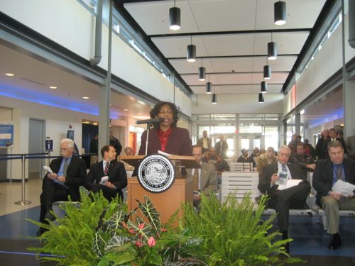
A year ago today the ribbon was cut on the Gateway Transportation Center in downtown St. Louis (view post).

11/21/2008
11/21/2008

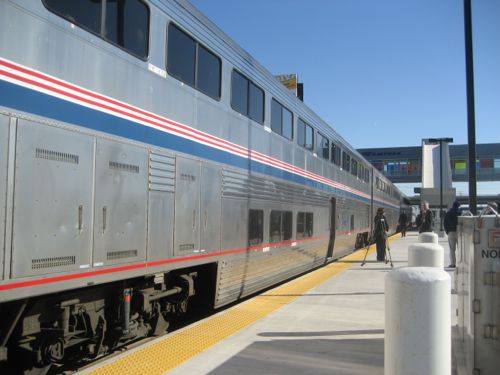
This station includes both Greyhound bus and Amtrak train and is adjacent to a MetroLink light rail station and a regional bus hub  (map link).  It is a transportation mecca.  Someone can use Greyhound to get to St. Louis where they can take MetroLink to the airport or Amtrak to Chicago.  Or just stay in St. Louis using the light rail or bus service to explore the city and some of the region.

Comptroller Darlene Green speaks at Nov. 08 ribbon cutting

The interior is no Union Station but it also is a huge improvement over the “temporary” shacks that were used for 20 some years.


Platform height allows for easy boarding

Security is better than other train & bus stations I’ve seen — only ticketed passengers can get to the train platform or the bus loading area.  I’ve yet to take a train or bus in/out of this new station.  I had used both the old stations.

Monday of this week a new long-term parking lot opened up. From the press release:

The secure 42-space parking area is paved, fenced, well-lit and monitored by security cameras. It is fully automated, only accepts credit or debit cards and offers the attractive rate is $6 for up to 24 hours and $6 for each succeeding 24-hour period.

For the 12 months ending September 30, 2009, Amtrak St. Louis ridership reached 278,778, an increase of nearly 2.5 percent (6,781 passengers) from the previous year.

If you have used the new station for bus or train service please share your thoughts below.

– Steve Patterson


Riding the #99 Downtown Circulator Bus

October 26, 2009 Downtown, Public Transit 13 Comments

Last week I rode the fairly new #99 Downtown Circulator bus with Metro employee Courtney Sloger.  I had met Ms. Sloger a few weeks earlier as part of a panel with Dr. Todd Swanstrom of the University of Missouri St. Louis discussing transit for What’s Up Magazine.  Sloger doesn’t own a car and uses transit herself.  She is one of a couple of writers on Metro’s NextStop STL blog.

It was at this panel discussion I first heard of the #99 bus.  I was so excited I wrote a post about it last month that included the route map:

When I agreed to ride the #99 with her I planned to use the opportunity to use my wheelchair to try the lift for entry/exit.  The battery on my chair decided otherwise.  With the chair no longer taking a charge I would need to drive my car to a point along the route.  To simplify meeting Sloger I picked her up at Metro’s offices in Laclede’s Landing.  I drove to 10th & Washington Ave where there was plenty of on-street parking on 10th.  The time was around 4:30pm a week ago today. The bus stop was just around the corner on Washington Ave.

One of the amazing things about this route is the frequency of the buses, only 10 minutes.  So we caught the next Westbound bus.  I rode a bus in Seattle in March so I knew I could walk up the steps without issue.  The buses being used are shorter than most in their fleet.  This makes navigating downtown streets easier.  Many seats still remained empty.

We headed West on Washington and turned left onto Tucker.  Nobody got on or off along Tucker.  At Spruce we turned right to head to the Civic Center Station with many bus routes, MetroLink, Greyhound and Amtrak.  The #99 doesn’t board/unboard inside the bus section but along 14th street adjacent to the bus terminal.  If you are passing through this point on the #99 be sure to get a transfer ticket when you board.

Resuming the ride when went in the direction we had just come from except now we were going East on Washington Ave.  We turned right (South) on Broadway.  We took Broadway South past Busch Stadium until we turned left at Poplar and left again on 4th.  I didn’t set my timer but the entire round trip was much faster than I expected.

Along the way we talked about destinations nearby and how to market the route beyond the current ridership, mostly blue-collar transit dependent riders from my observation.  I suggested the buses need a special look.  While I preferred new low-floor buses Courtney Sloger thought a wrap works into the budget better.  Agreed, just something to make the bus stand out from the others.

Many cities have transit lines to help you navigate from destination to destination.  But just who are those more likely to take a ride on the #99?

Downtown residents and office workers seems an obvious answer.  Tourists and visitors here for conventions?  The wrap should include the words “downtown circulator” in big letters, I suggested.  And a graphic of the route.  Listing destinations reachable via the bus would help too.

When I visit a city I like to ride a bus or streetcar line to observe what is out there so I’ll know what to come back to on foot.  But the current #99 misses one of the best parts of downtown, the two blocks of Washington Ave between Tucker and 14th. Visitors should see this.  Granted if they exited at Tucker when the bus turn they’d be right there but I think going through it is better.  I’d like to see the route modified to go up & down 14th rather than Tucker (12th). The problem is 14th is often closed at Chestnut for special events at Soldier’s Memorial.  I guess on those days the bus could take Tucker.

For tourists they’d still need to know where they are going because destinations are not announced. Many places are close, but not obvious, such as Citygarden, Union Station, City Museum, and Culinaria.  Someone might get into town late on a Saturday.  After checking into their hotel on 4th they could take the #99 to grab a bite at a number of places such as the 12th Street Diner at Tucker & Washington Ave. While the diner is open 24 hours on the weekend, the bus line stops around midnight.  Check the schedule for hours & directions.

I suggested Metro get hotel concierges to ride the route at least once.  Downtown guides too.

As a helpful tool for downtown residents I suppose it depends upon where you live.  If you are in the Edison Warehouse at 14th & Spruce it is am easy way to get you closer to stores like Macy’s, Culinaria and others.  The steps into the bus, however, make bringing on purchases a challenge.  For those of us West of 16th the line doesn’t help much.  For people in the Pointe 400 apartments (old Pet building) on 4th Street it would be an excellent way to connect with restaurants and other destinations  that are a good walk from your place.

I invite each of you when you are downtown next to ride the #99.  See what you think.  I like the possibilities it offers for the future.  Certainly needs a special look.  Most definitely needs low-floor vehicles to eliminate the steps.But it is a step in the right direction.  Thanks Courtney Sloger for pushing me to ride the #99.

– Steve Patterson
 

Metro Moving Transit Forward Without Streetcars

Through its “Moving Transit Forward” initiative, Metro is holding public workshops across St. Louis City and County to get folks thinking about transit needs and system expansion.  Rather than just let attendees dream up their own rapid transit lines on maps, a breakout exercise does a good job of sharing the stark financial realities of MetroLink expansion. Participants are given just a hypothetical $700 every decade for capital projects, when the average MetroLink corridor project costs roughly $450. As a result, it becomes quickly apparent that another Prop-M only buys roughly one MetroLink corridor a decade, if that. For example, the combined Northside-Southside corridors, just within the City, cost $800. The exercise also suggests that participants consider other, cheaper alternatives, such as Bus Rapid Transit ($35) or Commuter Rail ($300).

What really concerns me with this exercise is two-fold: 1) Northside-Southside is presented as the only big idea for City system expansion, and 2) Modern Streetcars are missing from the suggested tool box of cheaper alternatives. When thinking of streetcars, I’m not talking more vintage trolleys akin to the Delmar Loop project (that’s criticism for a future post). No, I’m talking low-floor, high-capacity vehicles that travel on cheaper-to-build, embedded, street-running tracks. But back to the first point, this former planner of the Northside-Southside concept actually thinks such a “big idea” is terribly flawed, and should even be scrapped.

To understand how Northside-Southside even came to be is to tackle the very complex history of system planning and evolution of MetroLink in St. Louis. Such history would be its own series of posts. But suffice it to say, the St. Louis region is still working off a 1989 system analysis produced by East-West Gateway as the basis for all its corridors. I admire Metro using their new Moving Transit Forward initiative to scrap the prioritization of that document that hasn’t been officially updated since 1991 in a failed attempt to lure St. Charles County. But showing a map of big ideas spawned from those very corridors dreamed up now twenty years ago is perpetuating flawed thinking. I know this in part, because the Northside-Southside Study, I worked on two years ago, also perpetuated inherent flaws.

In my opinion, the key flaw of the Northside-Southside Study was the dual purpose of serving both City riders and County commuters. As a result, speed of lines to the County became essential, but of course, at an expense. Faster trains meant taking lanes and closing intersections on arterials and complex designs inside Interstate rights-of-way, all for a fast-ride to Downtown. And given such premise, modern streetcars were deemed too slow, despite their lower cost. But in the end, many County stakeholders would view the project as a lower expansion priority, especially given a roughly billion-dollar price-tag, which ironically resulted from attempts to attract their ridership.

A political reality of Metro is that the County holds the purse and the populace (albeit in voters, if not riders). One can imagine then that if you can only expand MetroLink by one corridor a decade, the City will be waiting in line for some time. Plus, as Northside-Southside showed, the City doesn’t have as attractive exclusive rights-of-way to build MetroLink-looking lines easily.

Rather than compete in a game stacked heavily against the City, I advocate changing the transit ideas discussed inside the urban core. Modern streetcar corridors, such as Grand Avenue, would offer the City projects paired well fiscally with a County MetroLink extension each decade.

And there is still time for City transit advocates to be heard. One opportunity is attending the workshop scheduled for South St. Louis City 5-7pm this Monday (10/26/09):

  • St. Louis Public Library, Carpenter Branch
    3309 South Grand Boulevard (map)
    St. Louis, MO 63118

– Brian Horton


Downtown St. Louis has a Circulator Bus Route, Metro Routes on Google

September 29, 2009 Downtown, Public Transit 12 Comments

I missed the news about this line when some bus routes were temporarily restored but as part of Metro’s Partial Service Restoration Plan includes a circulator bus downtown.

The route does a loop through the central business district along 4th & Broadway as well as a stretch both ways along Washington Ave.  At Tucker it drops down to make a stop at the Civic Center transit center (bus, light rail, Greyhound, Amtrak). Frequency ranges from 10-20 minutes depending upon the day of the week and the time of day.  During normal working hours the buses run every 10 minutes.  The route takes riders past two MetroLink light rail stations.

The other big news is Metro routes are now available for viewing on Google Maps!  The default setting is by car but you can request routes by foot or by transit.  I’ve tested a few trips and it did a great job and included departure times for both bus and light rail trains.  From my downtown loft to The Tivoli theater on Delmar it gave me three route choices — one bus and two light rail.  The bus is the most direct and includes the least walking, I can see the stop where I’d board from my balcony.

For more info on routes and schedules see http://MetroSTL.org.

– Steve Patterson


If St. Louis Had the Density of Other Cities

Many think population density is all bad or all good.  To me it depends up0n how the population uses the land.

Much is said about St. Louis’ peak of 856,796 in 1950 and how over the last 50 years we lost over half a million people out of our small 61.9 square mile city.  We will never again be at that level but how we use our land with our current population level is important.  I think we can do better with the population we have.

For grins I thought it would be interesting to what the population of the City of St. Louis would be if we had the recent density of other major cities.  I picked 13 cities that came into my head and used density figures available from Wikipedia.  The results were both surprising and intriguing:

Portland OR has lower density than St. Louis?  Interesting.  I think they have a different mix — a very high density center transitioning to a very low density edge.  Oklahoma City is massive in total land area but with only a few rare exceptions it is uniformly low-density.  St. Louis of 1950 had greater population density of current day Chicago? Yes, St. Louis, in 1950, was more densely populated than Chicago today!

I’d like to think that with good planning (form-based zoning) we could aspire to a Seattle or Baltimore level of population density – at least 7,000 persons per square mile.

What this looks like is increasing the density along our major corridors such as Olive, Jefferson, Kingshighway, Natural Bridge, etc.

Goal posts should be something like:

  • 6,000/sq. mile (371,400) by 2020
  • 6,500/sq. mile (402,350) by 2030
  • 7,000/sq. mile (433,300) by 2040
  • 7,500/sq. mile (464,250) by 2050
  • 8,000/sq. mile (495,200) by 2060

This growth will not happen organically like it did a century ago. Our current zoning and other policies prevents such growth.  It will require hard work to create the plan & zoning for dense corridors.  These will need, and will support, excellent mass transit.  Our tidy streets of single family, 2-family and 4-family buildings need not change from their current density levels.  The growth will occur along the corridors that last century changed into to-centric.  Hell, basically.

I doubt I’ll be around for the 2060 Census but I want to steer us in the right direction so by that time we can reach this goal.  Plus the US population is expected to grow some 45% by 2050.  If we grew at the expected national rate we’d have 514,000 by 2050.  So to have 464,250 by 2050 (31% growth) seems like a reasonable expectation.

We have the vacant buildings ready for new occupants.  We have the vacant land for in-fill construction. Still need to work on the schools to educate the youngsters.

– Steve Patterson


Advertisement


[custom-facebook-feed]

Archives

Categories

Advertisement


Subscribe