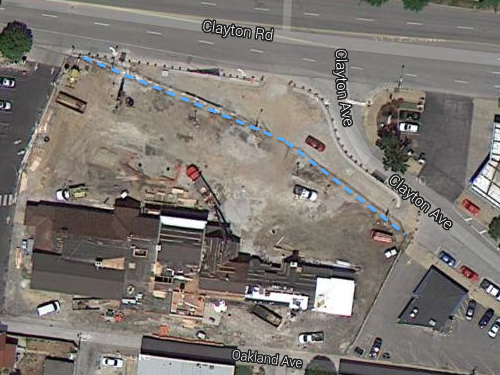
Intersection of Clayton Road & Clayton Ave Still Not Right
In the last couple of years the intersection of Clayton Rd & Clayton Ave, between the giant Amoco sign and Cheshire Inn, went on a much-needed road diet.
Click image to view map
The space gained from reducing the public right-of-way is now part of the Cheshire parking lot, see the related: Pedestrian Access Route to The Cheshire Easily Blocked. Finally there was a chance to improve this intersection and get it right. Well, it’s improved — no doubt about that. Unfortunately, it isn’t “right” given that it’s new construction.
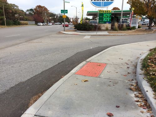
In addition to the ramps/detectable warnings being poorly situated, there’s no crosswalk. Crosswalks help guide the visually-impaired and reinforce to motorists to look out for pedestrians crossing the street. Pedestrians have the right-of-way, motorists must yield to pedestrians.
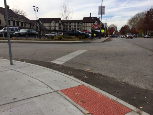
The City of St. Louis either designed this, or approved the drawings of the contractor. Either way it’s pretty pathetic given how easy it would’ve been to do it right. What would be right? Just look at the nearly identical situation at Olive & Lindell.
I’m emailing this post to various officials, including 28th ward alderman Lyda Krewson, though it’s too late now without great expense.
— Steve Patterson
OK, I’ll bite . . . Yes, Clayton Road needed a road diet, here, but really, is a new surface parking lot the best urban design solution / reason / answer?! And, besides ending up with a poorly designed pedestrian crossing at the new intersection, pedestrians now have to deviate around the new parking lot as they continue east on Clayton Avenue (across Skinker)! The only reason to cross here would be to head north on Skinker – proceeding due east on the four-lane Clayton Road just puts you on the I-64 on-ramp.
Since you drive often you can’t see the reasons why pedestrians would cross here: going to the gas station to buy something other than gasoline, getting off the bus on Skinker going to the Cheshire and other places on that side of Clayton Rd, etc
So you’re OK eliminating a straighter, more direct, primary pedestrian path of travel to a) build a bigger surface parking lot and b) create a shorter pedestrian crosswalk to get to a gas station / mini-mart?! In an urban setting? You’re stretching on this one! And, as “a driver”, my preference would have been to close and completely vacate Clayton Avenue between Clayton Road and Skinker – the signalized intersection at Skinker and Clayton Avenue complicates the signal timing at Clayton Road and Skinker.
I know what your saying JZ, but I would have been happy if they just eliminated the spur off of Clayton Road. My observations are that the traffic going across McCausland into Dogtown has been decreasing. Most of the traffic on this spur turns right on McCausland and head to points south. Elimination would only have meant a straight 90 degree right turn instead of a 60 degree turn.
There is also a design/build issue. Looking at Steve’s pic: I’m sure they designed it right, but when the concrete pourer was prepping, if he (or maybe she) had turned behind or looked up and noticed that if they just moved the bumper strip over one pad (maybe two), it would line up with the opposite sidewalk and then communicated this up the chain instead of just doing what the paper said then the problem would be much less.
The real problem is that Steve wants a straight line path of travel, ideally with two distinct ramps at 90 degrees on every corner. In Steve’s preferred example, the sidewalks are detached from the curb, here, they’re attached, closer to the traffic lanes. The corners require a minimum radius (for vehicles to actually be able to turn without running over the curb / sidewalk / pedestrians). Unfortunately, that moves the stop line back from the corner, creating sight line issues for drivers and creating greater hazards for pedestrians (since the drivers are going to stop where they can see oncoming traffic, not at some arbitrary, usually faded, line at non-signalized intersections, like this one) – paint ain’t Kryptonite. The other two issues are cost and maintenance – one raised truncated dome area costs half as much as two (duh!) and square curb corners are much more likely to get damaged than gradual transitions, like the ones here. This is functional, cost less to build (less forming) and will cost less to maintain. I’d bet that 8,000 – 10,000 vehicles pass here every day, while less than 100 pedestrians do, and less than 20 will have any sort of disability. It’s not “perfect”, but it’s certainly better for those few pedestrians than what was here before . . . .
There’s only one line of travel, so only one ramp/detectable warning is needed per side. On Olive they brought the curb line out into what was the parking lane so the ramp didn’t end up in the corner radius.
Approaching this corner (heading eastbound on Clayton Road), there is no parking lane, just 3 eastbound traffic lanes – the new sidewalk is sandwiched between the moving traffic and the parked cars in the expanded parking lot. The only way to get what you want would be to either eliminate the third traffic lane on Clayton Avenue, by making it a full-time parking lane or a tree lawn, or by moving the sidewalk south, taking out a row of parking in the parking lot. There’s limited real estate here, so compromises are required.
“This was just a cheap way for the Cheshire to gain a bigger surface parking lot”
Previously this area was entirely useless. Now it at least provides parking for a local business. I think that’s an improvement.
I agree that the previous configuration dedicated a lot of pavement to just driving and that the Cheshire needed more parking. Yes, it’s an “improvement”, but it’s far from perfect. My two points were that two-lane Clayton Avenue was there first and that this modification eliminated / changed the original alignment, not much differently than the Schoemel pots and new cul de sacs do in the CWE that urbanists rail against (there’s more pedestrian traffic crossing Skinker at Clayton Avenue than at Clayton Road / I-64 ramps) and that Steve, in other posts, seemed to argue that pedestrians should take precedence over vehicles in the design of new parking lots, and this does just the opposite, forcing pedestrians to to take a longer route than they did before to cross Skinker to head into dogtown.
What’s really in play here is what’s in play in every other urban design decision – while some things will get better – in this case, for pedestrians using the south side of Clayton Road – while some things will also get worse – in this case, for pedestrians trying to use Clayton Avenue. Two better solutions would have been to completely eliminate the Y here (no pedestrian conflict, at all) by making Clayton Avenue into a cul de sac coming off Skinker, to serve those businesses in the Hi-Pointe building, and to build structured parking with ground-floor retail here instead of a surface parking lot that still isn’t big enough!