Nineteen year ago I started this blog as a distraction from my father’s heart attack and slow recovery. It was late 2004 and social media & video streaming apps didn’t exist yet — or at least not widely available to the general public. Blogs were the newest means of …
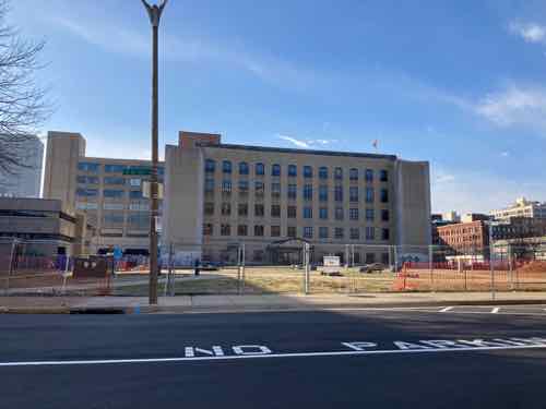
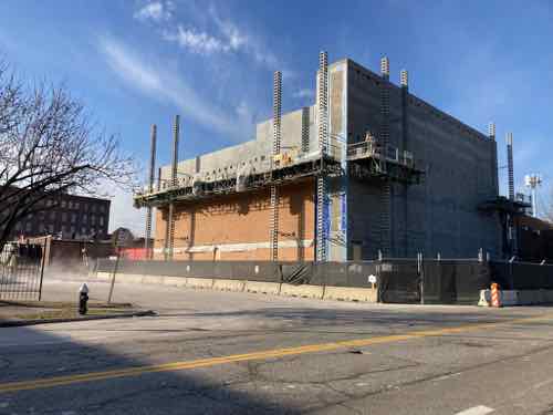
The new NGA West campus , Jefferson & Cass, has been under construction for a few years now. Next NGA West is a large-scale construction project that will build a new facility for the National Geospatial-Intelligence Agency in St. Louis, Missouri.This $1.7B project is managed by the U.S. Army …
Book publisher Island Press always impresses me with thoughtful new books written by people working to solve current problems — the subjects are important ones for urbanists and policy makers to be familiar and actively discussing. These four books are presented in the order I received them. ‘Justice and …
This post is about two indirectly related topics: the new Siteman Cancer Center building under construction on the Washington University School of Medicine/BJC campus and an update on my stage 4 kidney cancer. Let’s deal with the latter first. You may have noticed I’ve not posted in three months, …
January 16, 2023FeaturedComments Off on 19th Annual Look at the State of St. Louis’ Dr. Martin Luther King Jr. Drive Pt 1: Tucker to Kingshighway
Civil rights activist Dr. Martin Luther King Jr. was assassinated on Aril 4, 1968 in Memphis, Tennessee. In response cities began renaming streets in Black/Africian-American areas in his honor. St. Louis was a little slow at making this happen, it wasn’t until 1972 that Franklin & Easton Avenues became Dr. Martin Luther King Jr. Drive from 3rd Street to the western city limits at the Wellston Loop commercial district. The Veterans Bridge over the river was also renamed in his honor. Only 5 years later a block of MLK Dr. was closed (8th to 9th) for the Cervantes Convention Center. Over the years the remaining blocks east of Tucker (12th) have been closed, privatized, or cut off from the larger grid.
I started this blog on October 31, 2004, for MLK Day 2005 I did an extensive look at the condition of the approximately 7 mile corridor. Every year since I’ve continued, this is my 19th such MLKK Day post. Images for the easiest posts have become disconnected, but hopefully they’ll be reestablished in the future. The 2018 MLK post is a good prior example. Okay, let’s begin just east of Tucker and head west.
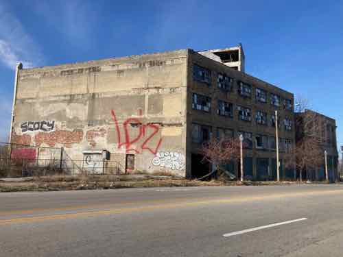
Interco Plaza, SE corner of Tucker & MLK, has been “closed for renovations” for a couple of years, basically since Square moved into the former Post-Dispatch building to the north and they didn’t want any homeless around.
I do like that MLK has been narrowed, though not very elegantly. Not sure how a person with visual impairment is supposed to understand this.
A lot of the blocks immediately west of Tucker have been surface daily car storage, but some now have chargers for electric vehicles.
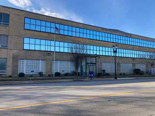
The medical building on the NW corner of 14th & MLK was originally built by BJC, but they didn’t stay long. It has had various tenants, but is vacant once again. Unfortunately it is built as if it was in an auto-dependent suburb — set back behind car storage.
Walls going up on the SW corner of MLK & 17th, this is owned Cybertel or Verizon.
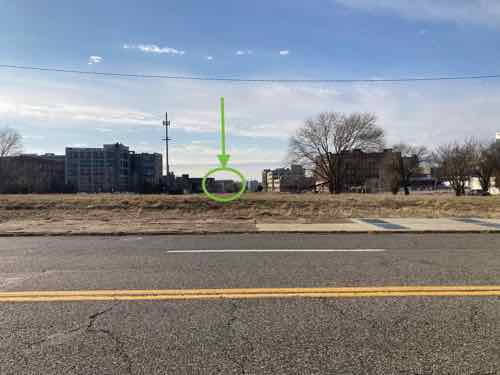
Between 21st and 22nd you see empty land, once planned for a western highway loop around downtown. The green arrow points to CITYPARK, the new soccer stadium. Hopefully this vacant land along MLK will also get redeveloped eventually.
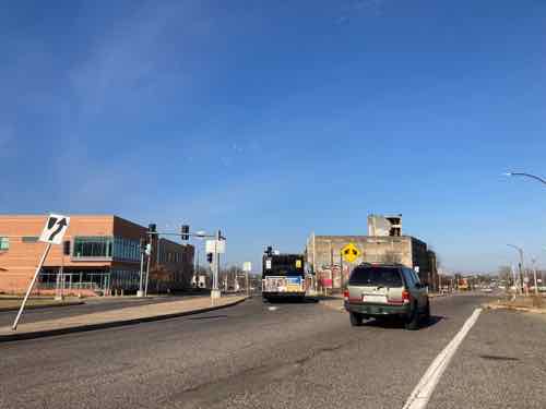
At Jefferson we can see work has begun to reduce the excessive width of the curb to curb distance, reducing the number of lanes — AKA road diet. For former RV park turn tiny home village on the NE corner can be seen in the background.
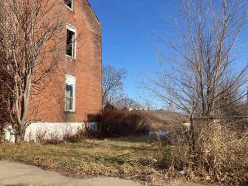
The two buildings at 30xx MLK have been deteriorating every year, but the front facades look about the same.
The flounder on the east one has completely collapsed, the rubble remains.
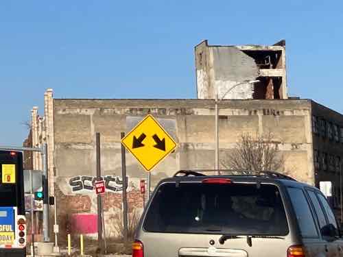
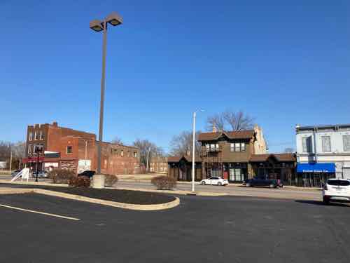
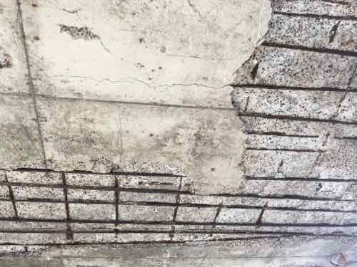
At the point where Page Blvd splits off to the left is a couple of deteriorating warehouses.
In this close crop of the previous image you can see how part of the freight elevator penthouse has collapsed.
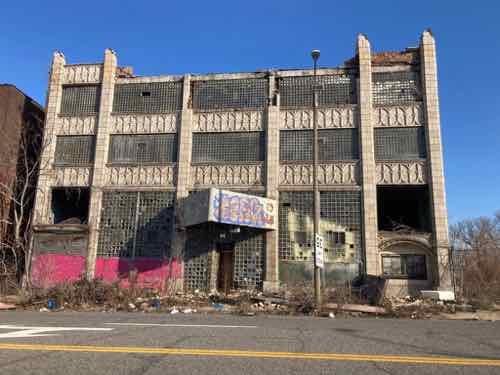
The Page Blvd facade is the front, clearly falling apart. Neighborhood residents recently sued developer Paul “Northside Regeneration” McKee to take control of the building.
Both buildings viewed from the west.
A nonprofit previoulsly purchased this property west of Vandeventer Ave, but it doesn’t look like they’ve done anything in the last year.
Just west of Belle Glades Ave is a favorite, the scaffolding suggests this well-maintained building continues to receive TLC. Unfortunately, the building to the west was lost a few years ago. Great infill opportunity!
The same seen from across MLK.
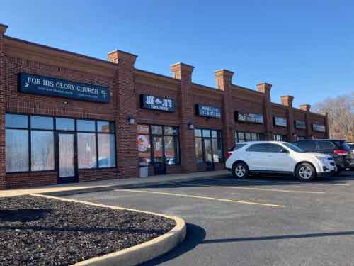
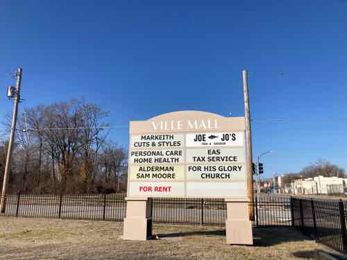
The north side of MLK still contains urban storefronts, while the south side contains an auto-centric strip mall. This was built within the last 20 years by a nonprofit associated with, but not controlled by, St. Louis University. The intention was business incubator space.
Like any good suburban strip mall, the VILLE MALL has a huge monument sign on the SE corner of MLK & Whittier St. Rather than have storefronts on the corner we see fencing & grass. Alderman Sam Moore, a tenant died in February 2020. Moore loved having parking out front.
Moore’s successor Dwinderlin “Dwin” Evans took over the space facing Whittier. Evans is not a candidate in the primary next month.
In the long block west of Whittier St, on the street a blue tarp has blown off a roof, at 4246? Wouldn’t be surprised if this building begins deteriorating faster, unless someone recovers or replaces the roofing.
I was pleased to see new construction in a city block that backs to MLK.
Unfortunately it is set back behind car storage. Pendleton & Evans Avenues
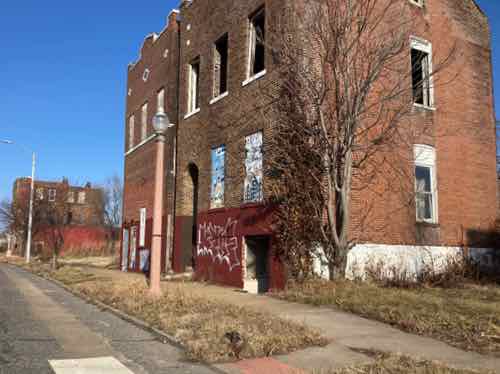
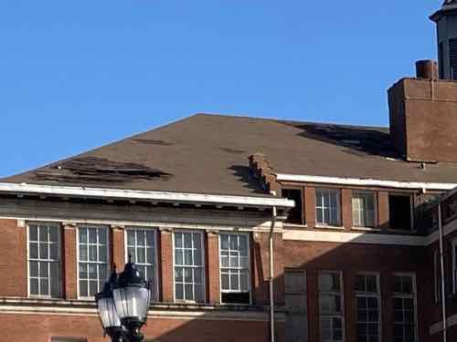
Returning to MLK at Newstead I see the vacant Marshall School. I remember when it was occupied, attended some community meetings here.
This crop of the above image shows open window and holes in the roof. This school building faces Aldine Ave, is for sale by the St. Louis Public Schools.
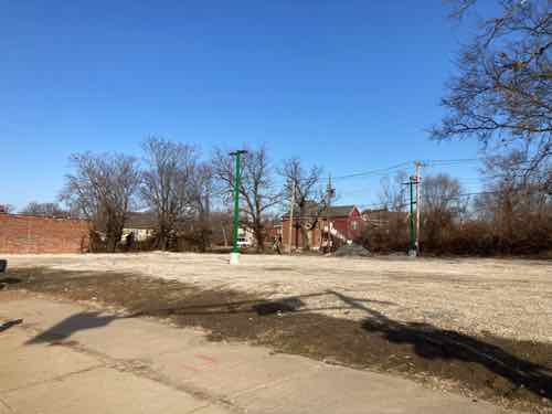
The vacant land on the NW cornet of MLK & Cora Ave has fresh gravel and new lighting. Looks like upgraded car storage.
The larger site across MLK also has fresh gravel. Unlike the other, this wasn’t previously paved.
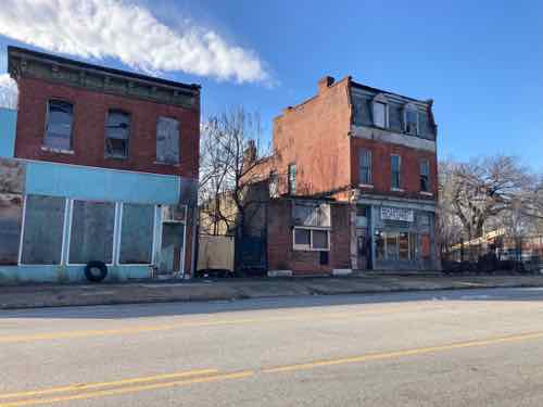
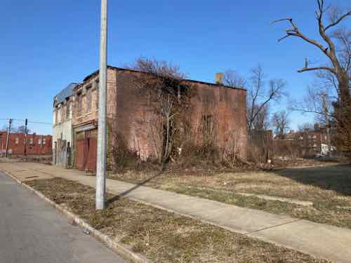
The buildings at 47xx continue to deteriorate. These are on the south side of MLK just before Walton Ave.
Back on the north side of MLK the east side wall of 4859 continues to collapse. Side walls are structural in most St. Louis buildings like these.
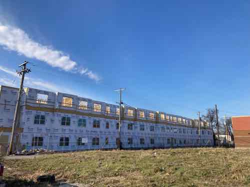
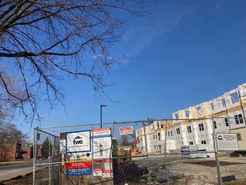
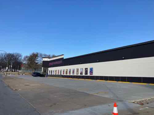
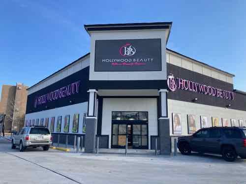
For several years now a new commercial building has been under construction on the north side of MLK, just before Kingshighway. In the lsat year it has been expanded with a corner entrance — all set back behind car storage.
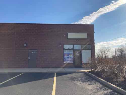
This new Hollywood Beauty wasn’t yet open on 1/7/23.
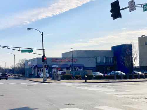
The location on the SE corner of MLK and Kingshighway, in a former Blockbuster Video, was busy. Will be intersection to see if anything is occupying this space a year from now.
— Steve ———————————————————————— St. Louis urban planning, policy, and politics @ UrbanReviewSTL since October 31, 2004. For additional content please consider following on Facebook, Instagram, Mastodon, Threads, Bluesky, and/or X (Twitter).
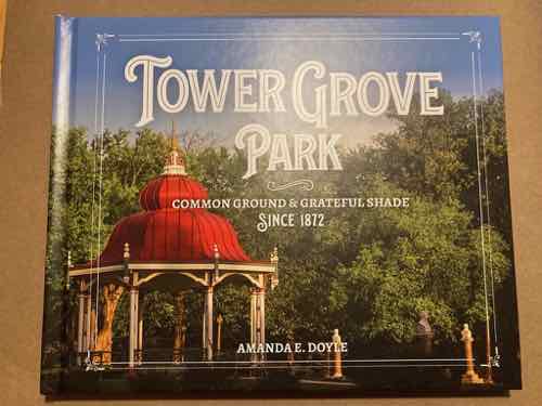
January 9, 2023Books, Featured, ParksComments Off on Recent Book — “Tower Grove Park: Common Ground & Grateful Shade” by Amanda E Doyle
St. Louis has some wonderful parks, built at different times for different reasons. One of the more unique is Tower Grove Park. It wasn’t constructed by the city like so many of our parks — it was gifted to the city. It has always had a board to oversee the park — it’s not just one of many under the Park Dept. A recent hardcover book takes a deep dive into the park.
Cover of recent hardcover coffee table book by Amanda Doyle.
Following the success of his Missouri Botanical Garden, English transplant and enthusiastic philanthropist Henry Shaw turned his attention in the late 1860s to creating the first large park in St. Louis, a Victorian showplace full of verdant trees, shading pavilions, and music and cultural amenities. Above all, Tower Grove Park was “not created for the benefit of any particular class, but for the enjoyment of all classes—for the use of the city population in the aggregate.” Such a tranquil oasis served to uplift, refine, and refresh human beings whose lives were becoming increasingly mechanized, crowded, and complicated . . . and 150 years after its founding, Tower Grove Park continues to fill that role in the lives of St. Louisans and the rest of the region.
Step into the past with this richly illustrated history of the park, including descriptions of the people and pavilions that created its unique architectural identity; appreciations of its lush tree canopy and vast biodiversity in the heart of an urban setting; and stories of the many individuals, groups, organizations, and events that have brought recreation and renewal within its acres. And follow along to the thoroughly modern uses and future plans that keep this park for all seasons more relevant now than ever, a necessity for the health, hope, and well-being of St. Louis. — Reedy Press
Author Amanda Doyle, a friend for over two decades, has lived near the park as long as I’ve known her. This coffee table book is well illustrated and informative. The “grateful shade” part of the subtitle is very true, many parks helped provide relief from the hear in the days prior to air conditioning.
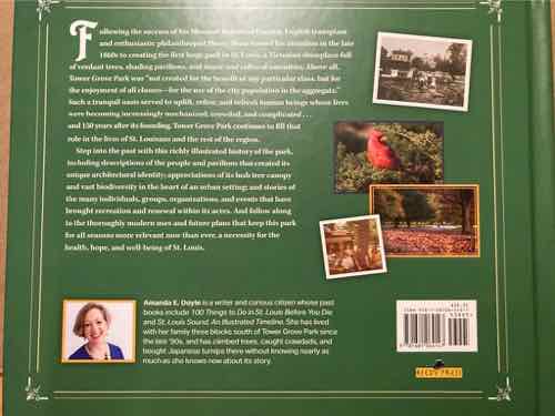
Back cover
Like many of you I’ve biked through, attended events at a pavilion, and shopped at the Tower Grove Farmers Market. Doyle has been holding many book signing events, she’d probably love it if you bought your copy directly from her.
— Steve ———————————————————————— St. Louis urban planning, policy, and politics @ UrbanReviewSTL since October 31, 2004. For additional content please consider following on Facebook, Instagram, Mastodon, Threads, Bluesky, and/or X (Twitter).
The 2023 spring municipal elections in St. Louis will be very different than any of us have every experienced. There’ll still be a March primary and an April general — but the primary will be non-partisan, both will begin the change from 28 wards to 14. The primary is 8 weeks from tomorrow.
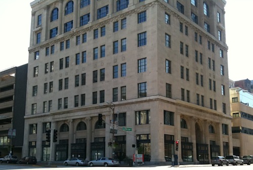
The St. Louis Board of Election Commissioners is on the first floor at 300 N. Tucker (@ Olive)
We’ve had the nonpartisan primary for one or two elections, but with 28 total wards. This being the first election downsizing to 14 there are no incumbents — all 14 seats are new and up for election. Seven will be elected to an initial 2-year term, the other 7 to a 4-year term. This will make future elections staggered, with only half the seats up for election every two odd years.
Until changed, races with only 1-2 candidates will be the same for primary & general elections — rather silly. Races with 3+ primary candidates will have the top 2 primary finishers on our general election ballots.
Remember— nearly everyone in the city has a new ward number. The March 7th & April 4th elections are both important — at least wards with 3 or more candidates in the primary.
Okay, let’s look at each race. The number in parentheses is the number of candidates in the primary, the areas listed are some/all of the neighborhoods in this ward. The President and ward headings are all links to relevant maps.
Incumbent Megan Ellyia Green only recently won a challenged special election to finish the term of disgraced Lewis Reed, so it’s no surprise she’s not challenged now. I suspect this will not be the case in 2027.
This southwest ward has three candidates — one of several races pitting current aldermen against each other: – Bret Narayan, current 24th ward alderman – Joseph (Joe) Vaccaro, current 23rd ward alderman – Casey Otto
This south ward has only two candidates, so both will appear on the March & April ballots: – Joseph (Joe) Vollmer, current 10th ward alderman – Helen Petty
This central corridor ward has three candidates, including 2 current aldermen: – Tina (Sweet-T) Pihl, current 17th ward alderman – Michael Browning – Michael J. Gras, current 28th ward alderman
Pihl and Browning live in the 63110 zip code, Gras in 63108.
This north central ward has only two candidates: – Laura Keys, recently elected 21st ward alderman, finishing term of John Collins-Muhammad. – Carla (Coffee) Wright
At five, this north ward has the most candidates of any! Seven filed, but one didn’t meet the signature obligation and the other withdrew. The remaining five on the ballot are: – Darron M. Collins-Bey – Tishara T. Earl – Yolanda (Glass) Brown – Walter Rush – Sharon Tyus, currently the 1st ward alderman
Collins-Bey, Brown, and Rush live in the 63115 zip code, Earl in 63147, Tyus in 63113.
This far north ward has three candidates — all three currently serving on the Board of Aldermen: – Norma J. Walker, recently elected 22nd ward alderman, finishing term of Jeffrey Boyd – Pamela Boyd, current 27th ward alderman – Lisa Middlebrook, current 2nd ward alderman
Walker lives in the 63120 zip code, Boyd in 63136, Middlebrook in 63147.
This north ward is my ward, I’ll have four candidates to choose from in the primary: – James Page, currently serving as 5th ward alderman – Brandon Bosley, currently serving as 3rd ward alderman – Rasheen Aldridge, currently serving as 78th district state representative – Ebony M. Washington
James Page lives in the 63103 zip code, Bosley and Aldridge in 63107, Washington in 63106.
Current aldermen not running in 2023
The following ten aldermen are not candidates (current ward): – Dwinderlin Evans (4th) – Christine Ingrassia (6th) – Jack Coatar (7th) – Annie Rice (8th) – Dan Guenther (9th) – James Lappe (11th) – Bill Stephens (12th) – Carol Howard (14th) – Jesse Todd (18th) – Marlene Davis (19th)
Additional thoughts
All this means at least fifteen of the current 27 (there’s one vacancy) ward Board of Aldermen will end their service in a few months. Given that 28 wards are being cut in half to 14 this isn’t a surprise. As many as 25 of the current 27 could be out of office after the general election in April — that number is shocking!
Two former aldermen, Florida & Ortmann, are hoping to return to the board. Both previously lost a reelection bid to a challenger in a democratic primary. Again, city elections are now nonpartisan. Florida will face the same person in the primary and general, Ortmann is in a 3-way race that includes a current alderman so his immediate goal is to finish in the top two in the March 7th primary so he can try to win the April 4th general.
Voter information
I want to leave you with helpful resources to help make your decision and voting easier. I’m very curious if we’ll see any significant change in voter turnout. Analysis will be a challenge since we can’t compare the 14 new apples to apples, but we can see citywide as well as compare old vs new in the same part of town.
— Steve ———————————————————————— St. Louis urban planning, policy, and politics @ UrbanReviewSTL since October 31, 2004. For additional content please consider following on Facebook, Instagram, Mastodon, Threads, Bluesky, and/or X (Twitter).
January 6, 2023Featured, Site InfoComments Off on Old-ish Blogger Learning New WordPress Editor
If you’ve noticed the number of posts dropped in 2022 compared to prior years this is for two reasons: living with cancer is a full-time job and the latest update to my self-hosted WordPress blog no longer has the editor I’ve used for 17 years. The ”classic” editor has been completely replaced, so this old dog is forced to learn new tricks. The last few posts have been via the new editor, but not by choice — just trying to get something simple published.
Steve Patterson in 2009
When I started this blog on Halloween day 2004 I was using software from Apple. I quickly joined other pioneer St. Louis bloggers using TypePad (I think that was the software). In January 2006 I went solo with my own online server with a self-hosted WordPress installation. Over the years the programmers behind WordPress have continually made changes, improvements. These were very gradual.
The new ”block editor” has been around a few years now, apparently, but I’d always been able to use what I was familiar with — until recently.
Now we’re in a new year and the holiday season is behind us, so I’ve been reviewing tutorials and excited by the ”easy“ new formatting options included, no plug-in required. I’m using this post to try out how this editor works. This practice will allow me to work on regular posts including my annual look at Dr. Martin Luther King Drive, candidates for the Board of Aldermen, recent books, new electric vehicles, etc.
My goal this year is to resume regular posting, move the blog to a shared server, and get a new template. Moving the blog to another server is so this blog will be available after cancer has gotten the best of me, the new template is for a fresh new look. Sorry, not interested in allowing comments again — too time-consuming to moderate.
I’m not old, I’m old-ISH.
— Steve ———————————————————————— St. Louis urban planning, policy, and politics @ UrbanReviewSTL since October 31, 2004. For additional content please consider following on Facebook, Instagram, Mastodon, Threads, Bluesky, and/or X (Twitter).
In 1961 the former Stix, Baer & Fuller department store began building a 900-car parking garage, attached to its downtown location via a skywalk over 7th Street. Six plus decades later the old Stix store contains apartments, hotel, a museum, and restaurants. The garage is now surrounded on 3 sides by the convention center. The skyway connecting the two has been sealed for years. See 701 North 7th Street on Google Maps.
The dome can be seen un the background in this August 2010 image
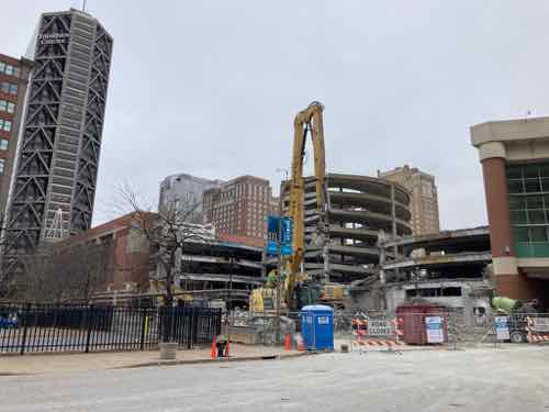
Recently the city was able to purchase it. There’s no funds in the current convention center expansion project, AC Next Gen, to replace the garage. It was inspected, condemned for use, and now being razed.
With ongoing demolition the circular ramp was visible from the street, November 11, 2022
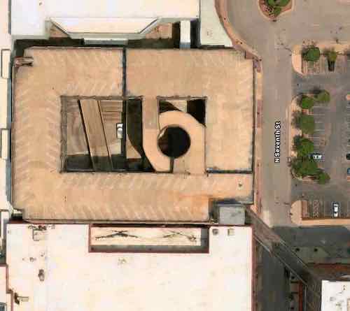
It had a lot of open/unused area in the center, with a circular ramp popular at the time. The 2nd floor of the 1993 convention center expansion connected to a level in the back. A new garage would certainly be designed very different. Prior to the early 90s the garage occupied an entire city block (#166), surrounded by 7th, Convention Plaza (aka Delmar, Morgan), 8th. The soon to be vacant site has 196 feet of frontage along 7th Street, it is 270 feet deep.
3D view of the garage from Apple Maps
Aerial view, the skywalk was visible in the lower right. Apple Maps
Before the city rushes to fund & build a conventional new garage to fill the site I think it makes sense to explore alternative options. We are talking about a full city block, though closed on 3 sides.
Doing nothing, holding for the future, is always an option. Another is a modern conventional parking garage. Beyond that it’s possible some of the back of the site might be useful to the convention center. At the street it would be nice to see some active uses, perhaps a restaurant(s) on the upper. A rooftop patio, balconies, etc are all worth considering to enliven the street. Residential and/or office space probably wouldn’t work, though I’m always looking for places for more low-income accessible units.
I’d love to see any parking be automated. These take half as much land as a conventional garage with ramps & drive aisles consuming a lot of space. They do cost more per space, but depending on the design of using half the block for active uses other than parking static vehicles for hours at a time could make it worth the investment. Various designs and costs/benefits need to be reviewed — before a commitment is made!
Big benefits include no need for mechanical ventilation or 24/7 lighting interior, but fire suppression is still necessary. Vehicles would be secured against theft or break in, the roof could hold solar panels. My only reservation is how automated parking would do with large events, such as an XFL game at the dome. Not sure if EV charging is possible.
My point is this city blocked-sized parcel needs to be examined from today’s perspective looking forward 50 years (2023-2073).
AARP Livibility Index
The Livability Index scores neighborhoods and communities across the U.S. for the services and amenities that impact your life the most
Built St. Louis
historic architecture of St. Louis, Missouri – mourning the losses, celebrating the survivors.
Geo St. Louis
a guide to geospatial data about the City of St. Louis