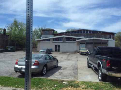
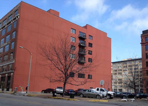
There’s a building on West Florissant Ave, across from the entrance to Calvary Cemetary, that has intrigued me for years. A former gas station with a large unfinished 2-story addition, city records show the original was built in 1971 but no indication when the addition was started.
5250 W. Florissant back in late April 2014, click image for map linkA few days ago
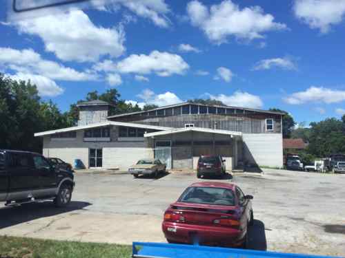
It’s always looked vacant to me, but the other day I noticed someone entering or exiting the building as I passed by on the #74 MetroBus. The building is owned by a husband & wife, both lawyers, they’re also part of the ownership of the package liquor store inside. The property was previously part of the 1st ward, but became part of the 3rd ward after the last redistricting. I looked at aerial images on HistoricAerials.com, the addition existed in 1998 — 16 years ago. I don’t recall a time before the addition, I moved to St. Louis in 1990. I can’t believe how long this has been like this, how much could it cost to put some vinyl siding over the plywood sheathing? — Steve Patterson
WIELANDY, Paul J., books and stationary; born Jefferson City, Mo., June 5, 1864; son of John F. and Junigunde (Wagner) Wielandy; educated in St. Louis public schools; married, St. Louis, June 28, 1904, Louise Angermueller. Entered employ of Shorb & Boland, wholesale booksellers and stationers, 1879; travelled for John L. Boland, successor of Shorb & Boland, in Colorado, New Mexico and Arizona. 1884-1901; in Jan., 1902, with A. M. Blackwell, of Las Vegas, N. M., organized the Blackwell-Wielandy Book and Stationary Co., of St. Louis, Mo., importers of jobbers of books, stationary, fancy goods, etc., of which is vice-president. Republican. Protestant. 32º Mason. Knight Templar. Club: Mercantile. Favorite recreations: fishing and hunting. Office: 714-720 Washington Ave. Residence: 2928 Harper St. (pages 610-611)
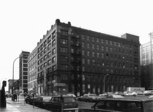
His business address of 714-720 Washington Ave is now the site of the US Bank Tower, formerly Mercantile Bank. In 1907, the firm Wielandy used to work for, built a new warehouse at 1601 Locust:
In 1910, the Boland company was acquired by the Blackwell-Wielandy Book & Stationery Company which moved into the 16th and Locust building from their head quarters at 714-20 Washington Avenue. One of the founders of Blackwell-Wielandy, St. Louisan Paul J. Wielandy, formerly had been employed for twenty years as a sales man for Boland. During his pioneering years as Boland’s representative in the Southwest, Wielandy met Missouri-born Arthur M. Blackwell who by then, was a successful merchant and bank director in New Mexico. In 1901, the two men returned to St. Louis where they established the firm bearing their names. Among the innovative new products first manufactured by Blackwell-Wielandy around 1912 were an adjustable ring device for loose leaf notebooks and the Blue Jay writing tablet — both popular items with the school trade. The Blue Jay brand was later extended to other supplies such as ink, crayons, paste aid composition and notebooks. (source)
Let’s take a look:
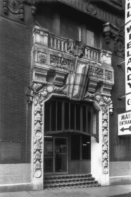
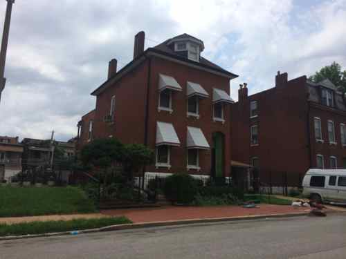
Designed by Designed by St. Louis architect Albert B. Groves, March 1983 photo from nomination to the National Register of Historic Places, click to viewEntry to 1601 Locust St, Blackwell-Wielandy’s office & warehouseSadly, 1601 Locust burned in a suspicious fire, was razed in 1988, has been surface parking ever since.
The building with the red wall, above, was built in 1919 as an annex to their original building. Within the last decade the annex was converted to condos, I’ve lived here since November 2007. The original was wood framed, the annex has a concrete interior structure.
In 1906 Wielandy lived in North St. Louis at 2928 Harper St.
Paul J. Wielandy died on March 4, 1953, two months before his 89th birthday (death certificate), he’s buried at Saint Peter’s Cemetery in Normandy (find-a-grave entry). According to the bio he was “a director of the Municipal Opera Association & of the St. Louis Safety Council & was a member of the first Highway Commission.” I need to research when Jefferson Ave was straightened out, widened, and connected to Natural Bridge, just blocks from Wielandy’s home, no doubt he supported the idea, making his drive to work on Locust St easier.
The store is now closed. I’ve been reviewing materials on revitalizing low-income areas and one theme is repeated: JOBS! Critics would correctly point out it would take a lot to convince an employer to move their business to a depressed low-income area, that’s why the business and jobs must be created from within.
Anchor institutions—hospitals, colleges, and other institutions deeply rooted in their communities—are a form of commons that is viewed as crucial to revitalizing low-income neighborhoods. Besides being major employers and big customers for local businesses, they have an intrinsic stake in making sure their neighborhoods thrive. Your local hospital, for instance, is not going to pack up its beds and move to Mexico.
<snip>
An initiative in Cleveland aims to help local residents become owners of new businesses that serve a cluster of hospitals, universities and cultural institutions on the city’s struggling East Side, including the famed Cleveland Clinic and Case Western Reserve University. The Cleveland Foundation teamed up with Ted Howard of the Democracy Collaborative at the University of Maryland to launch the Evergreen Cooperatives: 1) Evergreen Cooperative Laundry, an environmentally conscious employee-owned firm with a contract to clean linens and scrubs for local hospitals; 2) Green City Grower Cooperatives, an employee-owned 3.25 acre greenhouse that produces greens year-round for hospitals and the university; and 3) Evergreen Energy Solutions, where worker-owners install photovoltaic panels and make weatherization improvements for anchor institutions and local residents. (source)
The Evergreen Cooperatives of Cleveland, Ohio are pioneering innovative models of job creation, wealth building, and sustainability. Evergreen’s employee-owned, for-profit companies are based locally and hire locally. They create meaningful green jobs and keep precious financial resources within the Greater University Circle neighborhoods. Worker-owners at Evergreen earn a living wage and build equity in the firms as owners of the business.
The strategic pillars on which the Initiative is built are: (1) leveraging a portion of the multi-billion dollar annual business expenditures of anchor institutions into the surrounding neighborhoods; (2) establishing a robust network of Evergreen Cooperative enterprises based on community wealth building and ownership models designed to service these institutional needs; (3) building on the growing momentum to create environmentally sustainable energy and green collar jobs (and, concurrently, support area anchor institutions in achieving their own environmental goals to shrink their carbon footprints); (4) linking the entire effort to expanding sectors of the economy (e.g., health care, our aging population, local food, and sustainable energy), many of which are recipients of large-scale public investment; and (5) developing the financing and management capacities that can take this effort to scale (that is, to move beyond a few boutique projects or models to have significant municipal impact).
In the 2nd post, above, I listed the major institutions in the area. Between them they hire out for many goods & services. It’ll take a lot of effort to do what Cleveland has done, but I don’t think we have a choice in the matter. There’s no guarantee this will work, it certainly isn’t a magic bullet to solve all the ills. If you’ve got another idea I’d love to hear it.
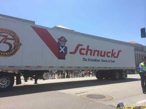
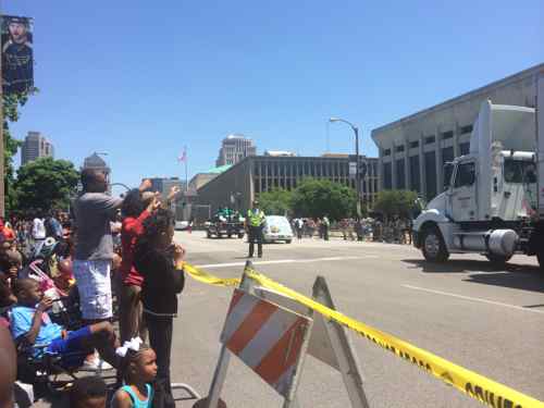
The annual Annie Malone parade on Sunday was a nice family event, but one entry drew jeers not applause from spectators.
Schnucks parade entry was an undecorated semiOne man near us stood to voice anger over the closing of the North Grand Schnucks location, click image to see prior post on the subject
It was nice to see his passion, especially after all the businesses in the parade. After visiting the now-closed Schnucks store I understand the business decision. I do think Schnucks, through their development company DESCO, could’ve been working on building a new location for years. Closing the north Grand location because a new store opened nearby would’ve gotten Schnucks a different reaction from those at the parade.
Recently I suggested the 9th & 10th one-way couplet should be returned to two-way traffic. I emailed numerous official a link to the post along with a brief summary, I heard back from only two; Ald. Tammika Hubbard replied within a day and a few days later St. Louis Traffic Commissioner Steve Runde replied. Runde confirmed it was doable, but traffic signal work can be costly. Both said it’s up to the neighborhood. That meant it was up to me if anything was going to change.
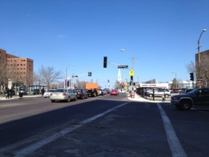
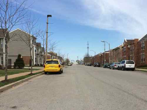
Looking north on 9th from O’Fallon St, lanes aren’t marked but wide enough for at least 3
The one-way couplet exists in two neighborhoods, in two wards: Downtown in the 7th Ward and Columbus Square in the 5th Ward, with Cole Street the dividing line (in more ways than one).
So I’ve started trying to figure out who to reach out to the Columbus Square neighborhood, which is fragmented by different developments:
Bottle District (unbuilt)
Cambridge Heights I & II
Cochran Plaza
Columbus Square
Courtyards at Cityside apartments
Neighborhood Gardens Apartments
Senior Living at Cambridge Heights
And a few more…
Many of these apartments are managed by McCormack Baron Ragan so I’ll contact them to find people to talk to.
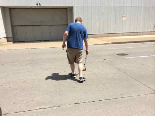
I’ve also started gathering data, the width of various streets are different points. Thankfully my fiancé DJF was able to help by operating the measuring wheel.
DJF measuring 9th Street at MLK, the convention center in the background
Here are the results:
9th @ MLK: 39 feet
9th @ Manhattan Pl: 44 feet
Manhattan Pl @ 9th: 24 feet
10th @ Blair: 34 feet
10th just south of Cole St: 40 feet
Locust St @ 16th: 42 feet (in front of our loft, previously one-way, for comparison)
I was surprised when we saw that 9th Street is 5 feet wider in the Columbus Square neighborhood, compared to downtown. Tenth Street varied widely, we need to measure in more places.
Based on the perception that wider lanes are safer, the St. Louis region has historically used 12-foot travel lanes for many thoroughfares. Recent studies show that at speeds of 35 mph or less, there is very little difference in substantive safety performance for lane widths of ten, eleven, and twelve feet. Narrower travel lanes can also have a TRAFFIC CALMING effect on a thoroughfare by causing vehicles to drive slower. Conversely, wider lanes often encourage motorists to travel above the facility’s target speed. If narrower lanes are chosen, it is important to carefully design the pavement (whether flexible or rigid) to maximize pavement life cycle. Pavement selection for narrower lanes should focus on durability to offset the effects of a confined wheel track space, which can produce early fatigue.
Design narrow lanes. Because slower speeds are desirable, lane widths under twelve feet are recommended, with 10′ as the minimum. Tables 6.2 and 6.3 of the ITE publication Context Sensitive Solutions in Designing Major Urban Thoroughfares for Walkable Communities provides excellent design parameters for ARTERIAL and COLLECTOR streets. These tables recommend a lane width of 10-11′ for the majority of place types, including those discussed in this guide. Chapter 9 of the ITE publication also provides useful guidance on lane width.
An on-street parking lane needs 8 feet, or 16 feet for both sides. Ten feet is a good width for a local neighborhood street. Both 9th & 10th have extra width,though the amount varies. How should this extra width get used up: bike lane, median, wider parking/travel lanes? Maybe residents like having 9th & 10th as one-way streets, though I doubt it.
In a future post I’ll look at 9th & 10th south of Cole Street, including going back to a traffic study from December 2005.
AARP Livibility Index
The Livability Index scores neighborhoods and communities across the U.S. for the services and amenities that impact your life the most
Built St. Louis
historic architecture of St. Louis, Missouri – mourning the losses, celebrating the survivors.
Geo St. Louis
a guide to geospatial data about the City of St. Louis