Last month I wrote Cortex District Needs A Pedestrian Circulation Plan Before IKEA Is Built knowing a master plan was in the works, or had already been approved. Still, I couldn’t find a copy online. I began emailing CORTEX directly, and then others, until January 10th when I got the response I was looking for:
Good morning, Steve:
John Hoal forwarded me your query about the Cortex Station Area Plan report. I spoke with SLDC, who confirmed that the report was not, in fact, posted on-line. The report has since been posted to SLDC’s website, and the link to the report materials is included below.
Thanks, Steve. Please let us know if you have any additional questions or require further information.
Best regards,
Timothy Breihan
H3 Studio
Turns out the report was finalized in October 2012! Fifteen months later, after my inquiries, it was made available online. This work was funded by tax payers and should’ve been made available when finalized:
The work that provided the basis of this publication was supported by funding under an award with the U.S. Department of Housing and Urban Development through East-West Gateway Council of Governments. The substance and findings of the work are dedicated to the public. The author and publisher are solely responsible for the accuracy of the statements and interpretations contained in this publication. Such interpretations do not necessarily reflect the views of the Government or the East-West Gateway Council of Governments. (Page 2)
Ok, it’s online now so let’s take a look:
Cover of the TOD study for CORTEX. Click cover to view on Scribd.
From the objective at the start:
Originally developed as a light-industrial enclave, the CORTEX district faces major challenges moving forward to make itself feel welcoming, pedestrian-friendly, and fundamentally connected to its surrounding neighborhoods and amenities. (Page 6)
[snip]
The Transit Oriented Development Study (TOD) for the CORTEX District (the Study) seeks to establish projections for net new riders on the MetroLink light rail system over a 20-year planning horizon resulting from the construction of a new MetroLink station in the CORTEX District. This Study is focused on proposed ridership projections based on planned investments in CORTEX and the surrounding areas. Metro Saint Louis Transit and the Bi-State Development Agency (Metro), owners and operators of the MetroLink and MetroBus transit systems, have established target thresholds as goals for proposed stations.
This station will be an invaluable asset in the future development potential of both the CORTEX district and the region-wide MetroLink system. The proposed station has the potential to function both as a transit option for current and future area residents and employees, as well as a major amenity and connective element for the surrounding neighborhoods and residents. In order to capitalize on years of public and private investment and attract and retain the best and the brightest, it is imperative that development in the CORTEX district unlocks the latent potential present in the district’s enviable location in the heart of Saint Louis. The City of Saint Louis, Metro, and CORTEX possess a significant opportunity to recreate the district as a key link between surrounding neighborhoods, with the ability to tie these neighborhoods together with public spaces, great pedestrian streets, mixed-use development, and multi-modal transit access. (Page 6-7)
The first “consensus issue” surrounding CORTEX is listed as:
1. Forest Park Avenue is perceived as unfriendly to bikes and pedestrians for east-west travel and crossing. (Page 11)
Really? The planning process gets into trouble when too much weight is given to public input. Forest Park Avenue has what they want to create one block south on Duncan Ave.; on-street parking which separates traffic from pedestrians, tree lawns with mature trees, etc. But a few neighbors that probably don’t walk indicated they don’t like Forest Park Ave., possibly because they were steered that way, so it’s dismissed as an east-west pedestrian route. The crossings do need to be improved to get people into the CORTEX District and to/from the proposed MetroLink station.
Under “scenerio 1” to increase transit ridership they list:
Focus TOD residential and mixed-use development between Sarah Avenue and Vandeventer Avenue and extend planned Duncan Avenue streetscape improvements east to Vandeventer. (Page 14)
But the proposed IKEA will prevent the new pedestrian-friendly Duncan Ave from reaching Vandeventer Ave, occupying most of the residential/mixed-use development area. Will this plan be amended to deal with that new reality? This is why major streets (Forest Park Ave.) shouldn’t be ignored in favor of expendable streets (Duncan Ave). Are ridership projections still valid with a large mixed-use area on the east side of the proposed station?
Let’s continue:
4. ENSURE PEDESTRIAN AND BIKE CONNECTIVITY, SAFETY, AND COMFORT
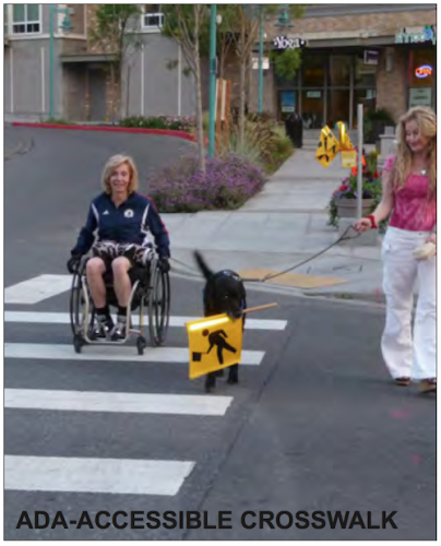
The photo on Page 119 labeled as “ADA-Accesible Crosswalk” shows a non-ADA compliant ramp. No diagrams are included on how to make ramps & crosswalks ADA-compliant.
Transit-oriented developments and districts rely on safe, comfortable, walk-able and bike-able streets and public spaces to provide access to transit. In the CORTEX district, streets are currently designed to give preference to vehicular traffic; most streets have only a 36-foot curb-to-curb width, which accommodates only two travel lanes and two parallel parking lanes. In addition, sidewalks are only 4- to 5-feet wide, pedestrian right-of-ways are often obstructed by utility poles and other infrastructure, and there are few street trees or other pedestrian amenities. Given limited right-of-way width and vehicular traffic restrictions, enhancing bike and pedestrian connectivity, safety, and comfort will need to occur on some streets while vehicular service requirements are accommodated on others. Actions to achieve this strategy include:
Create “pedestrian first” streets and vehicular-centric streets through the district.
Repair all sidewalks and maximize sidewalk width in all locations.
Provide planting strips and/or tree lawns on all streets.
Relocate utility poles and other infrastructure out of pedestrian right-of-ways.
Provide lane-width, shared lane markings (“Super Sharrows”) on all streets.
Provide parallel parking on all streets.
Provide street trees on all streets with a maximum spacing of 40-feet on-center.
Provide pedestrian-scaled street lights with a maximum spacing of 80-feet on center.
Provide trash receptacles, benches, bike racks, safety call boxes, and other street furniture.
Provide ADA-accessible curb cuts, oriented perpendicular to the street, at all intersections and crosswalks.
Provide pavement changes at all crosswalks. (Page 22)
Well “pedestrian first” is mentioned earlier (p13) and later on pages 69 & 119, yet nowhere does the report define “pedestrian first”. To be fair, “vehicular-centric streets” isn’t defined either, but I think St. Louis has that one down.
The big pedestrian push is Duncan Ave., which will terminate unceremoniously into the side of the IKEA:
A potential major east-west corridor within the CORTEX District is Duncan Avenue, which runs from Sarah Street and Vandeventer Avenue to the east and the Central West End MetroLink Station and Barnes Jewish/Washington University Medical Campuses to the west. Where Duncan Avenue intersects with Boyle Avenue is the heart of the CORTEX District with the CORTEX building to the north and the Solae building to the south. (Page 78)
It does include a list of existing conditions.
ASSESSMENT OF EXISTING SIDEWALK AND STREET PAVEMENT CONDITIONS
BOYLE AVENUE CORRIDOR
Overall, the street pavement is in poor to fair condition with alligator cracking, sections where base pavement is exposed, and numerous patches of pavement.
Curb material varies with either granite or concrete curb. Concrete curb is usually in sections where sidewalk has been replaced.
The standard curb height of six inches occurs mainly in sections where sidewalk has been replaced. Remaining sections of curb are less than six inches due to overlaying of street pavement.
The sidewalks are mainly in poor to fair condition with broken and uneven pavement. Numerous patches occur in the sidewalk pavement due to underground utility improvements. In areas where new construction or street improvements have occurred at street intersections, the sidewalks are in good condition.
TOWER GROVE AVENUE CORRIDOR
Some sections of Tower Grove Avenue have been newly overlaid with asphalt leaving them in good condition. Most other areas of the street pavement have alligator cracking, sections where base pavement is exposed and numerous patches of pavement and should be considered in fair to poor condition.
Overall the sidewalks are in poor to fair condition with prevalent pavement cracking and uneven areas. Some sections of sidewalk have been replaced at intersections with road improvements. Where new building has occurred, new sidewalk has been installed.
Curbing in this section of Tower Grove Avenue is mainly granite curb with concrete curb occurring at street intersections. Overlaying of the street pavement has reduced the height of the curb to less than six inches.
NEWSTEAD AVENUE CORRIDOR: FOREST PARK PARKWAY TO CLAYTON AVENUE
The street pavement is in fair to poor condition with numerous patches, large amounts of alligator cracking, and sections of exposed base pavement.
The sidewalks are in fair to good condition. Decorative medallions have been added to the sidewalk. A short section north of the MetroLink tracks has uneven and cracked pavement, and the east sidewalk from Forest Park Parkway to Duncan Avenue has some remnants of a sidewalk in places.
Curbing material overall is composed of granite, but some areas closer to Forest Park Parkway are concrete.
DUNCAN AVENUE CORRIDOR: NEWSTEAD AVENUE TO SARAH STREET
The street pavement is in poor condition with numerous patches, large amounts of alligator cracking, and sections of exposed base pavement from raveling top mat of asphalt and potholes.
The sidewalks are in fair to poor condition. There are several sections of sidewalk which have been replaced, and those are located on the north and south sides of Duncan Avenue at the CORTEX and Solae Buildings and parking lots as well as the West End Lofts parking lot near the intersection of Sarah Street and Duncan Avenue.
Curbing material mainly is composed of granite except in the sections of the CORTEX and Solae buildings. (Page 82-83)
HIERARCHY OF STREET USAGE BY PEDESTRIANS AND BIKES
From Stakeholder meetings with neighborhood committees and residents, City agencies and other concerned parties a hierarchy of primary pedestrian and bike routes were determined to help aid in the development of a Street-Level Connectivity Plan.
East-West Pedestrian Corridor:Laclede Avenue and Chouteau Avenue (Most Preferred) Forest Park Parkway (Least Preferred)
North-South Pedestrian Corridor:Newstead Avenue and Euclid Avenue (Most Preferred) Boyle Avenue and Taylor Avenue (Least Preferred)
East-West Bike Corridor:Chouteau Avenue (Most Preferred) Duncan Avenue (Least Preferred)
Hopefully you’ll be able to find detail I missed. To me this is a plan filled with buzz words that’s already being ignored a year later, business as usual. I’ll repeat: CORTEX needs a pedestrian plan because this isn’t close.
Yes, I advocate a public & transparent approach where problems & possible solutions are considered.
The current approach places too much weight on existing neighbors rather than a larger view of what might welcome more people to an area — important when making an investment in transit infrastructure.
AARP Livibility Index
The Livability Index scores neighborhoods and communities across the U.S. for the services and amenities that impact your life the most
Built St. Louis
historic architecture of St. Louis, Missouri – mourning the losses, celebrating the survivors.
Geo St. Louis
a guide to geospatial data about the City of St. Louis
Um, yeah but Steve, isn’t your input “The planning process gets into trouble when too much weight is given to public input.” public input too?
Yes, I advocate a public & transparent approach where problems & possible solutions are considered.
The current approach places too much weight on existing neighbors rather than a larger view of what might welcome more people to an area — important when making an investment in transit infrastructure.