Wayfinding In St. Louis
The St. Louis Convention & Visitors Commission has been rolling out a new wayfinding system in the region for a couple of years now. From a January 2011 Post-Dispatch editorial:
The St. Louis Convention and Visitors Commission has launched a $2.9 million initiative to design, build and install an attractive and comprehensive system of street, road and highway signs. The idea is to direct tourists and residents to a rich array of sites and attractions in the city of St. Louis and St. Louis County.
The project has been in the works since 2008. So far, about 300 signs — highway, street-level and pedestrian — have been installed or are slated for installation. The signs aren’t cheap: Fabricating and installing a large highway “guide” sign costs more than $20,000. (stltoday.com)
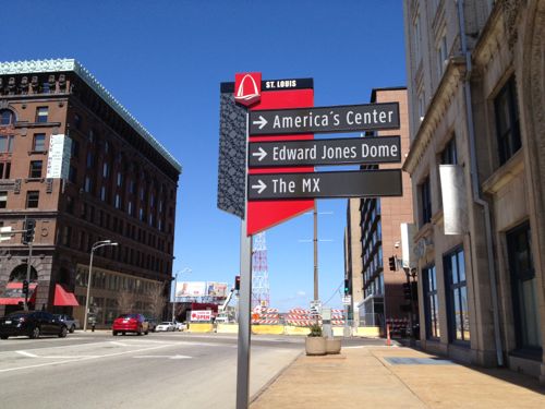
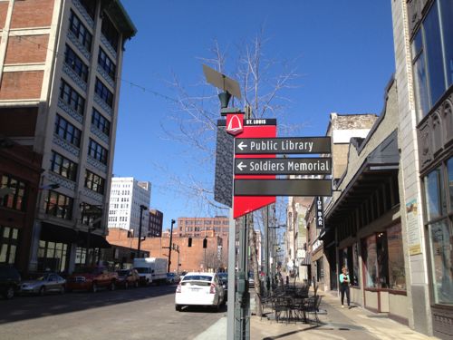
For example:
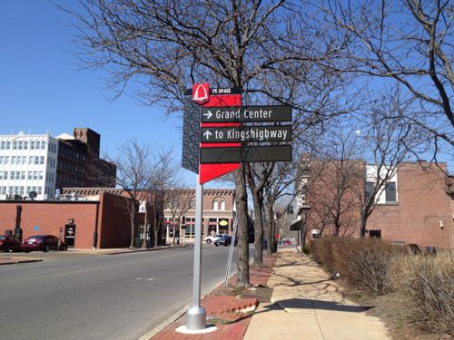
Lately these have begun to turn up downtown.
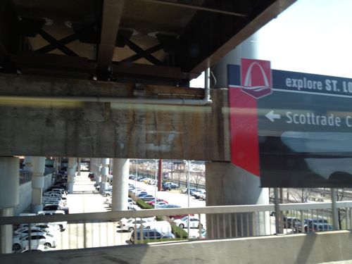
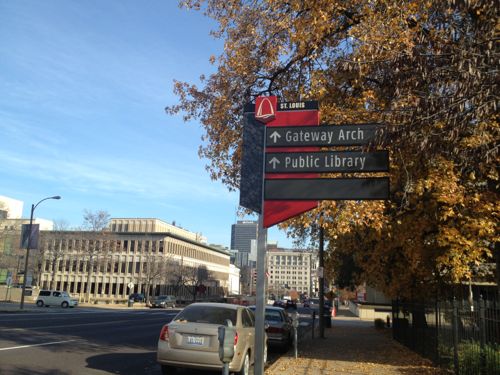
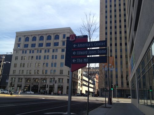
Until the other day all the signs I’d seen have been like the ones shown above, or larger highway exit signs. Them I finally spotted, at Citygarden, a sign to help pedestrians downtown.
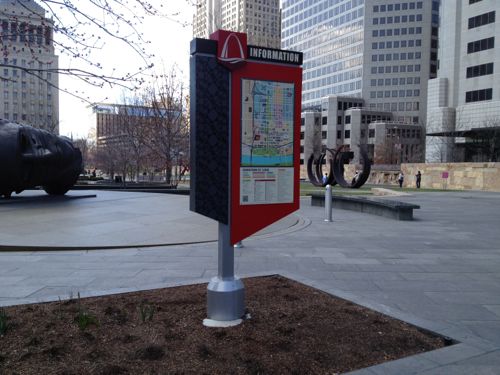
But it was placed in the middle of a planter bed so I wasn’t able to get close enough to evaluate its effectiveness. Great planning!
I get asked directions often and I enjoy helping others. Two common requests are for places very close to my loft: the Social Security office at 717 N 16th St and City Museum across the street at 701 N 15th St. The other day at 10th & Washington a woman asked where to find the “landmark Arch.” I pointed east on Washington Ave. When she asked if she should then turn right I told her she’d see it.
The following describes the process that took place to establish the system:
The Missouri Department of Transportation, along with the CVC, St. Louis City, Laumier Place, Grand Center and Forest Park funded the research needed to implement the program. Three “attraction corridors” were created in determining the locations of the signs. The first corridor is Broadway, second is Grand, and third is Kingshighway, with all three connecting major attractions and districts in the city. The entire program, including the research to implement the program cost 1.5 million dollars. CVC did apply for grants but was not successful in receiving any funding. The CVC worked with MODOT to identify those organizations that would provide funding for the wayfinding program. An important goal of the program for MODOT was to reduce sign clutter on the interstates in order to comply with Federal Highway standards. (continue at Cherokee Street News)
Hopefully I’ll be able to locate another pedestrian-oriented wayfinding map to evaluate. I don’t have a clear picture of the overall system and the CVC website wasn’t helpful.

Have you seen any of these new wayfinding signs? If so, what do you think?
— Steve Patterson
One, in theory, it’s a good idea. Unfortunately, it’s impossible to cover every potential scenario or destination. Two, with evolving technology (GPS & smart phones), is it even necessary? I love, and know how to use, maps, but many people don’t/can’t (one of the best comes from Chicago: http://www.transitchicago.com/assets/1/brochures/13JD_002_Downtown_Transit_Sightseeing_Guide.pdf .. ) Three, is this wayfinding or is this really advertising / marketing? Most people with a destination in mind will figure out how to get there before they leave home. The challenge usually isn’t in getting close / finding the place, the challenge is finding where to park or which transit stop is closest. And four, for other examples, you could look at the 16th Street Mall in Denver, where pedestrian wayfinding is an integral part of the design: http://www.livedowntowndenver.com/LDDBlog/?p=2939
Grand Center has a pedestrian map at Grand and Washington in Strauss Park. Lot of empty space on the Grand Center map. http://www.flickr.com/photos/pasa/8425214689/in/set-72157631617338815
Haven’t seen the new pedestrian signs….but I never really saw much of the original wayfinding signs either. Only in a few spots, and I thought they just seemed randomly placed. Definitely need more of both, I feel. Especially considering someone couldn’t figure out where the Arch was…
The goofiest sign appears on 64 and 44 near their respective exits for Grand. The heading: “Grand.” The list: “Grand Center” and “South Grand.” GRAND GRAND GRAND with no indication what any of those things might be.
https://maps.google.com/maps?q=st+louis&ll=38.617824,-90.252278&spn=0.001572,0.003484&oe=utf-8&client=firefox-a&hnear=St+Louis,+Missouri&gl=us&t=m&layer=c&cbll=38.617921,-90.252131&panoid=ph7IpC2D1qkIIrAxRLQwGg&cbp=12,132.42,,2,-1.32&z=19
This same thing is repeated on Kingshighway too, on the sign just before Arsenal.
And the sign at Arsenal on the West side of Kingshighway points north (left) to the Science Center, the Garden, etc…..the problem is that at Arsenal, there is no left (north) turn onto Kingshighway.
If I remember correctly, agencies pay for inclusion on these signs, right?
Yes…or at least that’s how it was for the previous run.
I don’t remember what the pricing was, but when working for Laclede’s Landing a few years back, it was too rich for our small operating budget. I don’t know if they’ve since opted for inclusion though…maybe on Washington Avenue at the America’s Center?
Clearly the execution wasn’t fully planned out properly (ie, pedestrian map placement, Grand/Grand/Grand) but overall I like them. Some people need to be punched in the face before they can see something and these signs help do that.
I do agree with JZ71 that most travelers likely pre-plan and have smartphones (or automobile GPS units) for which they would use for navigation. That’s what I do and so does everyone else I know.
whenever i come home from out of town, I find it funny that there is one of these highway signs that says “welcome to Saint Louis” somewhere around I-270. for a split second i imagine that the city/county have merged and that is our new city limits….but no.
I’m hopeful the footing at 1330 Wash AVE is for a well-placed pedestrian sign. It’s still an empty footing with bolts sticking up out of the ground.