Open Streets Event Today Highlights Cars Dominate St. Louis Streets Rest of the Year
 Today, Saturday October 8, 2011, St. Louis will block off a few streets so that pedestrians and cyclists can safely traverse them:
October 8, 2011, from 9:00 AM – 1:30 PM:
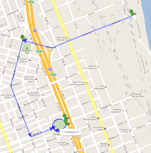
This Open Streets route will wind through Old North St. Louis. Connecting to the Old North Farmers’ Market and the Riverfront Trail, this route is excellent for serious cyclists as well as those who simply want to visit Crown Candy Kitchen, stroll through the marketplace, or see the community’s acclaimed revitalization of historic properties. This event will feature Healthy Living activities such as yoga and Zumba, as well as some of St. Louis’ favorite food trucks, live music, and art, active living, and culinary demonstrations. View the Old North St. Louis route at http://bit.ly/nNJOpxÂ
The other 364 days a year just drive.
The Open Streets events are somewhat interesting, gives me a chance to photograph buildings and streets from a position I might get only from within my car. Â Still it would be nice seeing more people out walking and biking all year.
The two I did last year had starting points in downtown — one right outside my front door. Today I must travel to reach the route. Naturally the MetroBus I take to get to Old North has a reroute because of the event:
#30 Open Street- 14th closed at St. Louis Ave and 13th closed at N Market
DETAILS
Due to Open Street, 14th street will be closed at St. Louis Ave. and 13th street will be closed at N. Market. The following reroutes will be in effect Saturday, October 8 from 9 a.m. unil 1:30 p.m.
REROUTE DETAILS
#30 Soulard NORTHBOUND
Regular route to 13th and Monroe, left on Monroe, right on N. Florissant, left on St. Louis Ave to regular route.
SOUTHBOUND
Regular route to St. Louis Ave and N. Florissant, right on N. Florissant, left on Monroe, right on 13th to regular route.
I’m a visual person to I had to look at a map to figure out the reroute. OK, I can get within a couple of blocks of the Jackson Circle, one of the endpoints of the event.
 It would be nice if they showed the bus routes on the map. From the “getting there” page:
Since Open Streets closes streets off to cars, we recommend alternative methods of transportation:
Mass Transit:Â Open Streets is conveniently accessible by MetroLink and MetroBus.
They provide a link to “Get to the Oct 9th Open Streets via public transportation” which targets 14th & St. Louis Ave — Crown Candy Kitchen. The #74 isn’t affected by the event but the reroute isn’t shown on Google Maps. Â This intersection is over 2 niles from the nearest MetroLink station! That means anyone wanting to participate using mass transit will ride the #30 or the #74, both of which can be boarded at the Civic Center station. But for novice bus riders it would have been nice of them to spell it out clearly.
I’m not yet sure if I will go but I am interested in photographing along the route.
– Steve Patterson
How do we make the streets more friendly to non-auto users all year round. Â How do we turn observations of problems into action towards progress?Â
How do we make the streets more friendly to non-auto users all year round. How do we turn observations of problems into action towards progress?
10HLLBZBSGDX I like it very much!