Evaluating Mobile Transit Directions in St. Louis
I do recall using public transit in St. Louis (and a few other cities) before the age of modern smartphones. Compared to today’s technology, it was primitive. Even since I’ve been a regular smartphone-carrying transit user the technology has advanced substantially.
The vast majority of Americans – 95% – now own a cellphone of some kind. The share of Americans that own smartphones is now 77%, up from just 35% in Pew Research Center’s first survey of smartphone ownership conducted in 2011.
A substantial majority of Americans are cellphone owners across a wide range of demographic groups. By contrast, smartphone ownership exhibits greater variation based on age, household income and educational attainment. (Pew Internet Mobile)
Even though a majority have a smartphone now, it doesn’t mean they all have lots of storage space for various transit apps or enough data to get information on them. Before we get into smartphone apps, here’s a graphic that shows you phone, text, and email options from our transit agency, Metro:
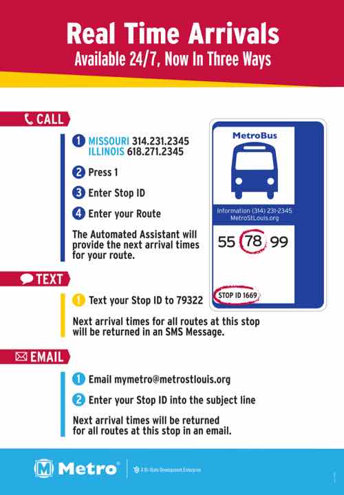
I’ve used the texting feature several times — works great. Even MetroLink platforms have stop IDs so I can text to see if the next train is the Red or Blue line. For this post I tested the phone & email options, both also worked fine.
Since my cataracts surgery (left eye) in August, I can actually read my phone while outside — including small print! As a result of being able to see again, I’ve been looking into other options besides the familiarity of Google Maps for local transit directions.
While driving I prefer Apple Maps, first released 6 years ago. Transit directions didn’t come to the app for quite a while, then only in bigger cities. I tried using it when we’ve visited Chicago, but I don’t know their system/routes well enough to trust a new app, so I stuck with Google Maps. In late March St. Louis was added to Apple Maps and I’ve been testing it off & on since.
The smartphone market consists of only two platforms now — Google’s Android and Apple’s iOS (iPhone). Google Maps is available on both, but Apple Maps isn’t on Android. I’ve also been testing Metro’s ‘Metro On The Go’ app which is available for both platforms. For this post I downloaded two other apps that are also available on both platforms: Transit & Citymapper. The latter doesn’t have St. Louis mapped, but it has some very nice functionality — more on it later.
I tested all, except the one that doesn’t have St. Louis map info, by trying to go from home at 16th & Locust to Solae/DuPont at 4300 Duncan Ave. — I go there frequently for taste tests. This is in the Cortex District and across Boyle from Cortex Commons & the Cortex MetroLink station that opened on July 31, 2018.
Google Maps (Android & iOS)
The majority of smartphone owners use navigation apps and most prefer Google Maps, according to new survey data from The Manifest. It has 67% of the market compared to 12% for Waze, 11% for Apple Maps, and 8% for MapQuest. (Apple World)
Google Maps, launched in 2005, is the dominant mapping service for both driving & transit. It shows me the most transit options and gives me the option to reduce transfers, reduce walking, etc.
Google Maps defaulted to the #10 bus, which I often take. For train only it wanted me to go to Union Station, not Civic Center, an easier route of the same distance, no elevator to deal with. I was able to use options to have it give me bus directions to Civic Center where I could catch a Westbound train. Interestingly, it wanted me to pass through the new Cortex station and get off at the Central West End station and walk back 2/10ths of a mile. D’oh!
I do like that when I open Google Maps, and search for a location, it defaults to the mode last used, usually transit on my phone. Having used it for transit in many cities, I’m most familiar with this interface. Other than wanting me to pass the Cortex station and walk back it does a good job. Earlier this year it did want me to transfer from one bus to another, not at the Civic Center MetroBus Center, but at 14th & Chouteau. I can’t recall where I was going when it did that, I reported it to Metro.
Apple Maps (iOS only)
Apple Maps rightly got skewered when it first came out, but like I said now I prefer it for driving directions. I tried using it for transit a few times in Chicago, but I don’t know their bus routes well enough to trust it.
Once St. Louis was added I felt comfortable giving it a try.
Apple Maps defaulted to driving…it always defaults to driving. Very frustrating! On transit mode it defaulted to train from Union Station. No option to catch a bus to Civic Center to catch a train. However, it knows the Cortex MetroLink station is open and closer to my destination than CWE Station. For my simple routes Apple Maps works fine.
Metro On The Go (Android & iOS)
Metro’s app is basically their web format in a handy spot. The next departure feature from favorite or nearby stops is now my go to for quick departure times. For example, when I finish at the doctor I can quickly find when the next Northbound bus is leaving from the nearby stop.
For the test it also knew to direct me from the Cortex Station. It defaulted to taking a bus to Civic Center to catch a train — what I do since the Cortex station opened 3+ months ago. The app is still a little crude compared to the more polished apps from Google & Apple.
Transit app (Android & iOS)
This app has good ratings and a fresh interface. I like at the bottom it shows you times to walk, bike, or the an UberX — with estimated cost.
![]()
Like Google Maps, it directed me to the CWE station rather than the closer Cortex station. I’m not going to delete it yet, will continue to use occasionally to compare to others.
Citymapper (Android & iOS)
Like I said above, this app doesn’t include St. Louis at this time. Still, I like the interface and options presented.
Showing walking & biking first is excellent, in my view.
Final thoughts
With 95% owning a cellphone, 77% a smartphone, the explosion of mapping apps, text services, etc really benefits the transit rider — both the daily & occasional rider. The trick is finding the right app for your particular needs. Being open to trying new apps is also a good idea.
— Steve Patterson