A Close Look at the Proposed St. Louis Streetcar in the CBD
Much of the talk about the proposed Downtown to CWE modern streetcar line has been focused on:
- The use of streetcar vs bus
- The east-west corridor vs investment in north & south St. Louis
- How the proposed route mirrors the 1993 MetroLink route
- How to end the line in the CWE, see post from yesterday here.
All valid topics, but today I want to zoom in to look at the route in the downtown central business district (CBD).
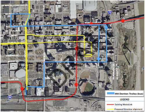
At this point in the streetcar process it isn’t known if the #99 Downtown Trolley bus route would remain, change or be eliminated completely. The draft report does note that operational savings could be realized through the elimination of a couple of bus routes. Eliminating the #99 would mean greater walking distances for service workers using transit since the proposed streetcar route has a more compact footprint, not a good thing for them.
East of 14th Street objectives that drove decisions regarding downtown alignments included:
- Get as close as possible to the center of the employment concentration.
- Minimize distance, physical and psychological, to major attractions, including the Arch Grounds.
- Reduce capital and operating costs.
- Minimize the number of curves to reduce noise and
- increase speed.
- Minimize the distance between tracks on one-way pairs. (The narrowness of the downtowtreets precludes double-track operation.)
- Eliminate impacts to MetroLink from streetcar construction.
- Lessen traffic impacts.
Application of those principles resulted, first, in the elimination of several options. Impacts to MetroLink during construction eliminated 8th Street and Washington Avenue. Traffic impacts, as cited by the City of St. Louis and the Missouri Department of Transportation, caused Broadway and 4th Street to be dropped, and the cost of extending the alignment from the downtown employment core to Memorial Drive eliminated that option.
This screening process resulted in a set of east-west streets that generally satisfied the evaluation criteria listed above. These included Chestnut, Pine, Olive and Locust Streets. North-south options were more limited and included 6th-7th Street and 9th-10th Street pairs. The former set was selected because it is closer to the heart of the downtown employment concentration and provides better proximity to major destinations. Olive Street is the logical eastbound half of an east-west one-way pair as it is a no-turn continuation of the alignment west of 14th Street. This results in a decision between Locust and Pine for the westbound segment. Locust was selected because of its centrality to the employment core, and because of its more pedestrian friendly first-floor uses, i.e., retail. Finally, the alignment south to Kiener Plaza addressed the strong desire from many stakeholders to provide direct and very visible pedestrian access to the Arch Grounds. (The plaza also provides a non-street layover point for streetcars.) In the next phase future coordination with the CityArchRiver 2015 project (draft study p14)
At Kiener Plaza a “layover point” is shown off street. This doesn’t fit with the latest concept for rebuilding Kiener Plaza. Such a change would need to be reviewed by the Gateway Mall Advisory Board, of which I’m a member.
Also not addressed is the use of 14th Street where it crosses the Gateway Mall (Market to Pine). Currently that is part of the “Civic Room” in the Master Plan. Currently 14th Street is frequently closed to traffic during major events like Taste of St. Louis and the Komen Race for the Cure. During these times the many bus routes that utilize 14th are rerouted on other streets but if 14th Street is used for the streetcar that means auto traffic may be rerouted but the streetcar needs to get through. This has major implications on the final design of the Civic Room and on event planning.
It was the relocation of the Saint Louis Law School that started all this, if Pine was used instead of Locust, that would be adjacent to the school. That said, I agree with the selection of Locust St. Yes, I live on Locust but at 16th so I won’t have a streetcar line directly in front of my building regardless.
It’s still early in the process but there’s lots to think about if this streetcar moves forward.
– Steve Patterson
There are many potential comments and observations, mostly technical in nature, but I’ll focus on the biggest one . . . what is your / the goal? Do you want to attract more daily commuters or do you want to create a downtown circulator? They’re pretty much mutually exclusive. Daily commuters want a quick, direct trip between home and work / school, and back (like on Metrolink), they don’t want to stop every block or two to let people on or off (like on a bus). Sure, during lunch, they may want to hop on and ride a few blocks, to shop or dine, but coming and going, the priority is to get to the destination, and back, as quickly as possible (which is one big attraction of single-occupant vehicles and at/near-the-door parking). Most people also don’t want to have to walk multiple blocks every day, either, and any route that is chosen will inform who will be attracted to the route – if you want to serve / attract SLU Law students, you better be close to the new Law School, and if you want to attract Federal Reserve Bank employees, you better be close to the FRB. Conversely, if you want to create a downtown circulator, a route that meanders throughout the CBD, hitting as many attractions and destinations as possible, with frequent stops, would be the most effective. Unfortunately, it ends up being an either / or situation, you can’t have it both ways – what do you really want to accomplish?
I’m a bit surprised that the proposed line (in yellow) doesn’t:
* Go down Washington Ave–the liveliest part of downtown (this is where you want the trolley to be!)–like the loop trolley will go down Delmar
* Stop directly in front of the Dome/Convention center
* Stop directly in front of Busch Stadium/Ballpark Village
* Stop directly in front of the Arch
* Stop anywhere near Union Station (I know it’s lame now, but c’mon!)
* Loop around the western part of downtown
I know that the Trolley stops within a few blocks of all these places but why make people walk when you don’t have to? Why settle for good when you can have awesome? I guess the idea is to keep the trolley off of the busy streets and out of the way of the holy cars…
“(The narrowness of the downtowtreets precludes double-track operation.)” – Really?
Yes, if you want to keep on-street parking on both sides and/or you want to keep streets one-way. The one “solution” that could work would be creating a dedicated “transit way” by eliminating vehicular traffic from some (lesser-used? secondary?) street(s), but that carries a whole series of other implications, usually negative. It has worked in Denver, and I think that it’s working in Dallas and Portland, but hasn’t worked well in Tampa or Memphis.