An event ia taking place tomorrow afternoon in a once-thriving commercial district: The Wellston Loop.
“Wellston Loop Family Reunion & Exhibit” will take place on Saturday, November 21 from 1 to 3pm. A sidewalk exhibition of recent photographs and historic documents will highlight the community. The event will offer free food, drink, music and videos. The primary venue will be the former J.C. Penney Department Store (on the National Register of Historic Places) at 5930 Dr. Martin Luther King Drive, St. Louis, Missouri 63112.
We’re inviting members of the surrounding community (past or present) who would like to share stories, photographs or videos of the neighborhood (Wellston Loop, Hamilton Heights and Wells/Goodfellow) from any era to submit them for inclusion and display.
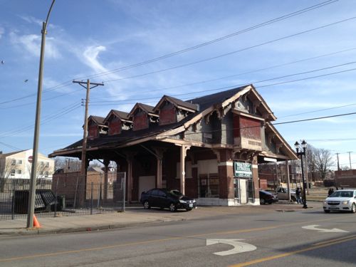
Another significant building in the former shopping district is the Wellston streetcar transfer station from 1909. It is also on the National Register of Historic Places. This building has recently been awarded funding for a complete historic restoration scheduled to begin December 2015. It is the only building of its kind (streetcar station building) left standing in St. Louis.
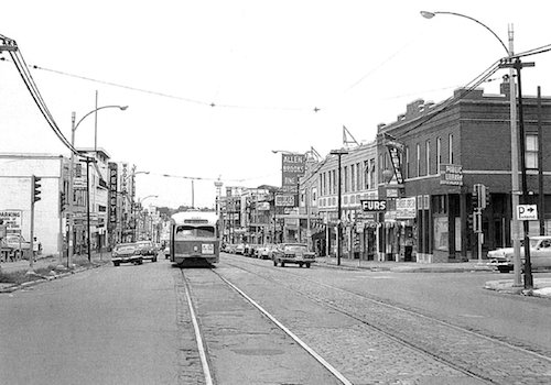
July 1963 image of The Wellston Loop from page 59 of the district nomination to the National Register, click to viewJust inside the city limits is the old Wellston Loop streetcar building, 2013 imageThe main location Saturday will be In front of the former JC Penny store at 5930 Dr. Martin Luther King Drive, click image for map. 2013 photo
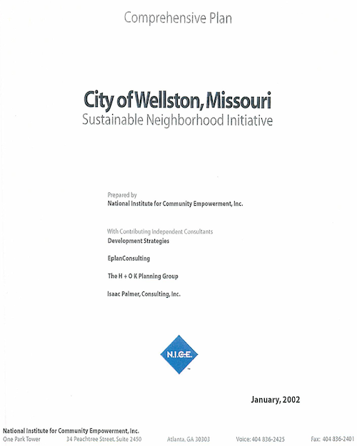
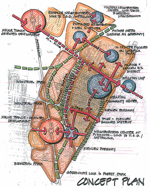
In October I posted about the New Wellston Child Care Center Under Construction, Adjacent To MetroLink Station, and noted promotional materials referenced compliance with the Wellston Sustainable Neighborhood Initiative. I wanted to see this initiative to see how the new construction complies, if it all. After a few emails I received a copy of the initiative — it had to be scanned! The initiative process started in 1998, the final document was from January 2002.
Click cover to view PDF on Scribd
The goals detailed were:
Raise the incomes of Wellston’s residents.
Improve the system of education in Wellston.
Improve the quality of Wellston’s neighborhoods.
Establish a central destination place in Wellston.
Improve access to employment, goods, and services for Wellston’s residents.
Improve the health and well being of Wellston’s citizens.
Enhance the image of Wellston and pride its citizens hold about their community.
Stimulate local economic growth.
Increase the social capital and improve the community capacity in Wellston.
Revitalize the MLK Corridor.
It’s hard to know how well Wellston has done with many of the above, however, the early development child care center now under construction should pay future dividends with respect to education, and eventually incomes.
Diagram from page 17
The report was prepared by The National Institute for Community Empowerment, Inc., which no longer seems to exist. I couldn’t find a website and their last phone number is not in service. A local contributor was the Regional Housing and Community Development Alliance (RHCDA), rebranded this year as Rise. Area Resources for Community and Human Services (ARCHES‘) is still around as well.
I’ve been looking through the report for the last month, developing questions to ask about the progress that’s been made in the last dozen years. The most obvious are measurable results toward the ten goals listed above. Do they consider a recent Family Dollar store and a gas station as having met #10, revitalizing the MLK corridor? Any positive gains in education? Given the Wellston School District shut down in 2010 and unaccredited Normandy School District struggles, I rather doubt there’s good news to report.
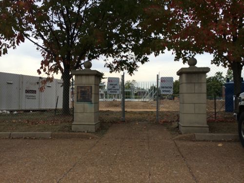
The new Wellston Early Childhood Center will open in the fall of 2014, not a moment too soon.
Construction workers are busy building a new child care center near the Wellston MetroLink station:
The Wellston Developmental Child Care Center is a key component of the Wellston Sustainable Neighborhood Initiative Masterplan. Located adjacent to a Metrolink Light Rail Sytstem (with which it will share parking) as well as being in close proximity to the Metropolitan Enterprise Center (a new job training center) will allow the Development Center to attain the goals of providing early childhood education in a depressed neighborhood, preparing children for the K-12 system, and providing day care assistance for parents training for new jobs.
The 14,650 SF building is oriented primarily on an E-W axis maximizing orientation for energy efficiency and daylighting. The building footprint had been placed on the site to minimize driveway length and take advantage of the adjacent public parking. Stormwater from the site will be handled by a series of micro-detention areas integrated with native landscaping. The program includes public, administrative, infant/toddler, classrooms and support spaces. (Hellmuth + Bicknese Architects)
I’ve requested the site plan & Wellston masterplan from the architects & county economic council, neither have been received.
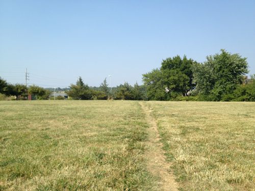
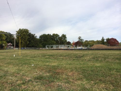
Construction of the building in Powell Park, seen from the far end of the station’s park-n-ride lotLast year Powell Park was just a field that area residents cut through to reach the bus & train. Click image for post.The long used shortcut is now blockedFrom the parking lot we see the point where the shortcut comes through the greenery
The shortcut was the most direct path for pedestrians to reach public transit. It wasn’t even paved, but since 1993 it was heavily used. However, I support building on the field — especially facilities that’ll benefit the community.
How will pedestrians now reach the station?
Rather than cut through the field to the right, pedestrians must now walk along Werley AveJust past the construction fence is the west edge of the large station parking lot.Turning east we see the parking lot, the station is at the bottom of the hill. The stop for the #94 MetroBus is on the left
The new child care center will use the existing parking, rather than have a separate parking lot. Still, the parking lot remains a divider between train, bus, residents, and new child care center. It’s possible pedestrian routes will be constructed in the parking lot to connect these elements. Without pedestrian connections the new construction is just transit-ajacent, not transit-oriented.
Once I see an actual site plan I’ll post an update.
In April I posted about the Wellston MetroLink Station and again yesterday. After attending three days of events with Dan Burden of the Walkable and Livable Communities Institute I’m convinced we can make improvements at low cost that deliver a big impact. I’d like to see the following happen between the MetroLink line and the MET Center some 300 feet to the east:
Allow on-street parking on at least the north side of Plymouth Ave
Replace the existing sidewalk with a much wider walkway, perhaps to the current fence line.
Plant street trees to provide shade
Remove fence to vacant industrial park
Remove earth berm on north side of fence
Construct liner buildings 15-22 feet deep where the fence and berm were located. The length to fill is roughly 240 feet to the industrial drive and another 100+ feet on the other side. These would be one story in height, although higher would be fine. The storefronts would provide retail/restaurant/office incubator space.
Build new sidewalks to actually connect the sidewalk to the entry to the MET Center so transit riders aren’t subjected to walking through grass and driveways and parking.
What’s a “liner building” you ask?
Liner Building Description: A building specifically designed to mask and enliven the edge of a parking lot, parking garage, public assembly or large retail facility (big box) along a public frontage.
Placement and Massing: Minimum frontage build-out is 60%. Minimum liner building depth is 16 feet. The façade along the ground floor on a Public Frontage must change visibly at an average of at least forty feet (40’) in height, setback, materials, or colors along the street frontage and with no module exceeding 75 feet in length. An entryway must be provided on the ground floor every 40 feet at a minimum. Courtyards or forecourts shall not exceed 10% of the street frontage. (City of Albuquerque North Fourth Street Rank III Corridor Plan)
There are many examples of liner buildings online but the basic idea is to construct inexpensive buildings (temporary or permanent) to either conceal something and/or to create a pleasing streetscape. Let’s take a quick look at the area.
ABOVE: Looking east on Plymouth Ave after crossing the tracks, on the left is the MET Center. The sidewalk should be much wider. The fence and earth berm would be replaced by a 1-story building(s). On-street parking would be allowed on at least this side of Plymouth Ave. Street trees would provide shade and make the walk more pleasant.ABOVE: The MET Center doesn’t have any route for pedestrians arriving on foot, the facility was designed to be driven to. I’d create a straight path from this point and another directly from Plymouth Ave.
The vacant industrial park is owned by St. Louis County. My idea would create roughly 7,000-7,500 of new retail space immediately adjacent to the Wellston MetroLink Station. Rather than be one small box this could be 7-10 incubator spaces. The wide sidewalk would be more inviting to pedestrians and could provide space for cafe seating in front of a small restaurant.
ABOVE: Rough diagram of the idea. The green circles are trees, blue rectangles the liner buildings and the gray new sidewalks.
Locals that live and work in the area know the needs best. Based on what I heard last week a small grocer would be good. This might be a co-op model like the Old North Grocery Co-Op. A small cafe, possibly part of the grocery co-op would also be nice. Passengers on MetroLink passing by the Wellston Station would do a double-take to see a tree-lined retail street with sidewalk tables and bright umbrellas.
I’d love to see local food production in the industrial park but past contamination means growing food in the soil is unlikely. An industrial building with an indoor hydroponic farm is a possibility though.
Other businesses might include a small bike shop modeled after St. Louis BicycleWorks, a newsstand, coffee shop, etc . I’m sure there are local residents that have a concept for a business, they just need help getting started and a place to operate.
I’m going to conclude with the same words I used yesterday: “I’m sure many of you can list numerous reasons why my list can’t/shouldn’t happen. I’m not interested. I’m interested in thoughts on how the type of connection that should have been built 19 years ago can finally get done.”
For both I made my observations from each station and seeing a lack of connection in various directions. Last week I found myself 9/10ths of a mile from the Wellston station so I got to experience the problems area residents face in reaching that particular station. Before I get into the problems I want to explain why I was nearly a mile from that station.
Walkability expert Dan Burden was in St. Louis for a few days last week. Thursday morning a group met at the MET Center near the Wellston station and did a “walking audit” of problems we observed.
ABOVE: Looking west from the MET Center toward the Wellston MetroLink station. Parking is a barrier between the entrance and the station.ABOVE: Dan Burden of the Walkable and Livable Communities Institute, click image for more info
The next afternoon a group met at the University City Library on Delmar at Kingsland (map) to discuss safe routes to schools. I’d arrived by MetroBus (#97). After the presentation we walking north to the new Pershing school. Well, it was very hot so everyone else drove and I made my way the 8/10th of a mile to the school.
ABOVE: Dan Burden and the group start to form a human traffic circle at Bartmer Ave & Ferguson Ave, the SW corner of Pershing Elementary School. Click image for map.
It was over 100 degrees and when we finished here the sessions were over, we were all on our own. A bus route was close but the sidewalk to reach it was blocked by construction at the school. I decided to “walk” to the Wellston Station in my power chair. I’m not sure when I left University City and entered Wellston.
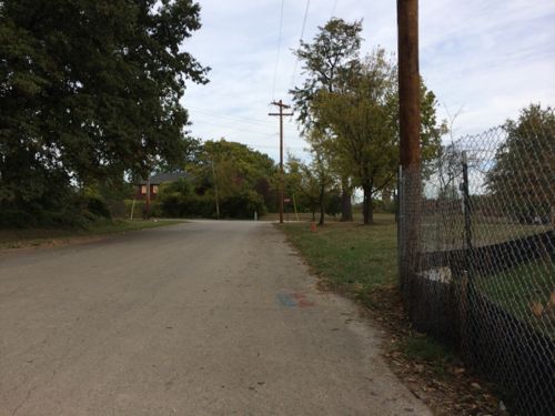
ABOVE: Habitat is building new houses on Bartmer Ave. This is looking east at Kingsland Ave, one block east of Pershing School. The police car is from University City.ABOVE: Looking east on Etzel Ave from 66th Street
The housing stock in Wellston appears older and not as nice even when new as the housing in nearby University City. Though modest, I didn’t feel unsafe in what many would consider a “bad area.” I encountered no one, probably because of the excessive heat. The sidewalks were all complete and passable until I got out of the residential area and into the industrial area near the station. Sixty-sixth street only had fragments of sidewalks, I ended up in the roadway.
The last part of my trip would take me through Robert L. Powell Park.
ABOVE: The last part of the journey would take me through Powell Park
I’d seen the park on map before and got up to it back in April to see the sign facing Metro’s largely empty parking lot.
The park was dedicated to Wellston Mayor Powell in 1993. In 1998 Mayor Powell resigned after being sentenced to a year in jail for using tax dollars to fund his reelection campaign and celebration party. Click image for more info.
The park is appropriately named because it’s a disgrace.
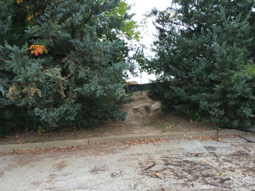
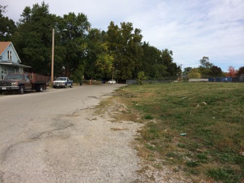
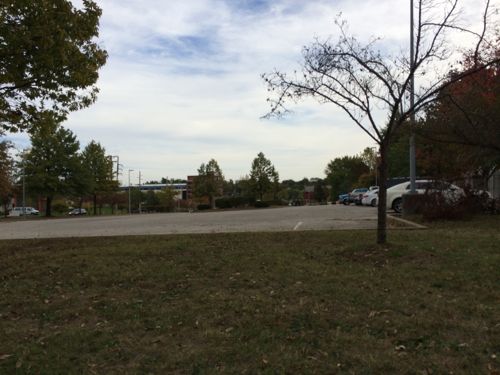
ABOVE: Powell Park is a giant square of grass with zero improvements.ABOVE: Over the last 19 years residents have worn a clear path across the open field…ur, parkABOVE: I went as far as I could but the grade dropped off. I had to go west to get to a point where I could get onto Metro’s parking lot.ABOVE: For 19 years people have been walking up/down this steep & dirty incline to reach transit.ABOVE: After the shortcut through the park the residents still have to walk through a parking lot. Pedestrians shouldn’t have to walk through a parking lot, they’re among the least appealing places to walk.
Once I reached the station I didn’t catch the train, instead I got on the #94 (Page) MetroBus since that’d drop me off only a block from my loft. It’s clear to me that in the last two decades nobody has done anything to make it easier for Wellston residents to get to transit. What can/should be done?
Replace sidewalks along 66th Street.
Pave path through Powell Park, plant shade trees along path and have a few benches and a water fountain. Will require a ramp to navigate the grade change.
Rename the park something besides a disgraced former mayor.
Develop the parking lot, provide a nice sidewalk to reach the light rail platforms and bus stops.
I’m sure many of you can list numerous reasons why my list can’t/shouldn’t happen. I’m not interested. I’m interested in thoughts on how the type of connection that should have been built 19 years ago can finally get done.
AARP Livibility Index
The Livability Index scores neighborhoods and communities across the U.S. for the services and amenities that impact your life the most
Built St. Louis
historic architecture of St. Louis, Missouri – mourning the losses, celebrating the survivors.
Geo St. Louis
a guide to geospatial data about the City of St. Louis