Home » Transportation » Recent Articles:

Readers Want the Impossible: Amtrak Trains at St. Louis Union Station

November 21, 2018 Featured, History/Preservation, Planning & Design, Transportation, Travel Comments Off on Readers Want the Impossible: Amtrak Trains at St. Louis Union Station
Grand Hall in St. Louis Union Station

In the recent non-scientific Sunday Poll readers overwhelmingly indicated they’d consider using Amtrak if trains departed/arrived at St. Louis Union Station.

Q: Agree or disagree: I’d consider taking Amtrak if trains arrived/departed at St. Louis Union Station

  • Strongly agree: 22 [53.66%]
  • Agree: 6 [14.63%]
  • Somewhat agree: 2 [4.88%]
  • Neither agree or disagree: 5 [12.2%]
  • Somewhat disagree: 0 [0%]
  • Disagree: 3 [7.32%]
  • Strongly disagree: 3 [7.32%]
  • Unsure/No Answer: 0 [0%]

Well, to the nearly 75% who agreed I have some bad news for you. Amtrak trains will never use Union Station again. Ever.

For more than 28 years I’ve lived in St. Louis I’ve heard people suggesting the return of Amtrak to Union Station and for 28 years I’ve just been struck by a complete lack of understanding about rail service and station design.

The decline of trail [rail] travel began following World War II, as traffic dropped significantly, even while railroads began to update their passenger fleets with new equipment in the 1950s hoping to retain passengers and ward off ever increasing competition from the automobile and airplane (the development of jet propulsion only worsened the situation).  Technically, passenger rail travel peaked in this country during the first two decades of the 20th century and slowly declined thereafter, particularly with the onset of the Great Depression.  However, it also did not help that President Dwight Eisenhower enacted the Interstate Highway System in 1956 (also known as the National Interstate and Defense Highways Act).  By that time railroads were beginning to see the writing on the wall and cutback their services, with most giving it up altogether by the start of Amtrak in 1971. (American-Rail.com)

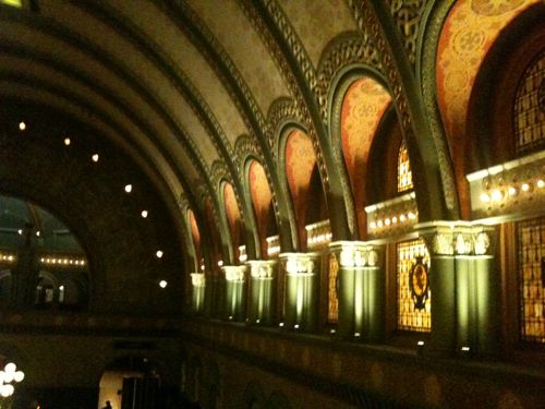
By the time the stock market crashed in 1929 St. Louis Union Station had been open for 35 years. This was a poor time to be the largest U.S. railroad station. The last train pulled out from the huge train shed 49 years later.  The main building (from “Headhouse”) hadn’t been used for nearly a decade. With only a few trains per day having such a huge facility made no sense. It would’ve happened sooner if another option existed.

Under the big shed in 2012

You might point out the Kansas City still uses their Union Station for Amtrak service. Yes, yes they do.  It’s a through-station, not an end-station.

Through-stations and end-stations are completely different design and planning problems.  They generate completely different kinds of space and completely different sensations of arrival and departure.  It’s pointless, for example, to compare New York’s dreary Penn Station, a through-station, with magnificent Grand Central, an end-station.  They are apples and radishes. (Human Transit)

In the 19th century when 22 railroads built Union Station they correctly saw St. Louis’ population computing to grow. They wanted a facility they wouldn’t outgrow like the original St. Louis Union Station on 12th (Tucker).  They decided their station would be an end-station, not a through-station.  Half a century later the decline of rail passengers, the failure of passenger rail companies, and the fact Chicago beat St. Louis as the midwest end city meant St. Louis Union Station, a beautiful design, was incredibly obsolete for rail travel.

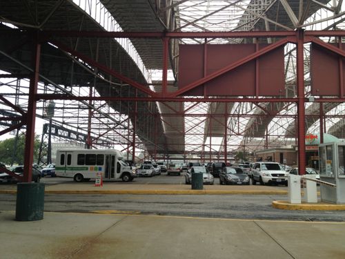
Kansas City’s Union Station has been able to reutilize most of the building to other uses, with Amtrak using a small part for ticketing and waiting, It’s a short distance out to the platform at the through tracks. From the back of the shed at St. Louis Union Station it’s still a very long distance to the tracks — plus office buildings and the closed movie theater block the path.

In the 70s Amshack was built at the tracks. I recall using this in the 90s. Then a slightly nicer Amshack 2 was built, I used this in the aughts. The station I’ve used the most opened a decade ago…today. Yes, it took until November 21, 2008 to open a proper station. I was there for the ribbon cutting ten years ago, and I’ve been back many times since as a traveling customer.

Comptroller Darlene Green speaking at the opening ten years ago

Over the last decade the maintenance was allowed to get behind, prompting me to label it Amshack 3 in 2017.  Thankfully it was improved on my last train trip, in February 2018.

Please understand Union Station is a magnificent asset to St. Louis — but it was last useful as a train station about 75 years ago.  Embrace the current station, or use the new Alton Station if you’re headed North on Amtrak. The rail improvements started during the Obama administration have greatly improved the St. Louis to Chicago experience.  Stop waiting for trains at Union Station — use the station we’ve had for the last decade.

— Steve Patterson


Sunday Poll: Would You Take Amtrak If St. Louis Union Station Was Still Used For Trains?

November 18, 2018 Featured, Sunday Poll, Transportation Comments Off on Sunday Poll: Would You Take Amtrak If St. Louis Union Station Was Still Used For Trains?
Please vote below

It has been over four decades since Amtrak stopped using St. Louis Union Station for passenger rail.  When it opened in 1894, replacing the original St. Louis Union Station, it had 42 tracks.

At its height, the station combined the St. Louis passenger services of 22 railroads, the most of any single terminal in the world. In the 1940s, it handled 100,000 passengers a day. The famous photograph of Harry S. Truman holding aloft the erroneous Chicago Tribune headline, “Dewey Defeats Truman”, was shot at the station as Truman headed back to Washington, D.C., from Independence, Missouri, after the 1948 Presidential election. (Wikipedia)

Amtrak, formed in 1971, used the station until a “temporary” station could be built along the tracks to the East. That began in 1978. There was a period where the Union Station’s main “headhouse” wasn’t used but trains still used the shed — the design allowed access to tracks without going through the main building.

I first came to St. Louis just 12 years after passenger rail service ended at Union Station. I had just traveled by train from Union Station in Washington DC though Union Station in Chicago to a tiny station in Kansas. There I caught a Greyhound bus back to Oklahoma City where I got my car and drove to St. Louis to take up permanent residence. However, passenger rail service had been in decline since before I was born. Interstate highways & air travel made rail service seem obsolete — hence the government’s consolidation of numerous rail companies to create Amtrak.

For 40 years rail service has been at locations other than St. Louis Union Station.  Does this make a difference when deciding how to travel?

Today’s non-scientific poll will close automatically at 8pm tonight. Wednesday I’ll have more on this topic.

— Steve Patterson


Evaluating Mobile Transit Directions in St. Louis

November 5, 2018 Featured, Public Transit, Transportation Comments Off on Evaluating Mobile Transit Directions in St. Louis

I do recall using public transit in St. Louis (and a few other cities) before the age of modern smartphones. Compared to today’s technology, it was primitive. Even since I’ve been a regular smartphone-carrying transit user the technology has advanced substantially.

The vast majority of Americans – 95% – now own a cellphone of some kind. The share of Americans that own smartphones is now 77%, up from just 35% in Pew Research Center’s first survey of smartphone ownership conducted in 2011.

A substantial majority of Americans are cellphone owners across a wide range of demographic groups. By contrast, smartphone ownership exhibits greater variation based on age, household income and educational attainment. (Pew Internet Mobile)

Even though a majority have a smartphone now, it doesn’t mean they all have lots of storage space for various transit apps or enough data to get information on them. Before we get into smartphone apps, here’s a graphic that shows you phone, text, and email options from our transit agency, Metro:

Call, text, or email to find out real time transit information. Click image for more information from Metro.

I’ve used the texting feature several times — works great. Even MetroLink platforms have stop IDs so I can text to see if the next train is the Red or Blue line. For this post I tested the phone & email options, both also worked fine.

Since my cataracts surgery (left eye) in August, I can actually read my phone while outside — including small print! As a result of being able to see again, I’ve been looking into other options besides the familiarity of Google Maps for local transit directions.

While driving I prefer Apple Maps, first released 6 years ago. Transit directions didn’t come to the app for quite a while, then only in bigger cities. I tried using it when we’ve visited Chicago, but I don’t know their system/routes well enough to trust a new app, so I stuck with Google Maps. In late March St. Louis was added to Apple Maps and I’ve been testing it off & on since.

The smartphone market consists of only two platforms now — Google’s Android and Apple’s iOS (iPhone). Google Maps is available on both, but Apple Maps isn’t on Android. I’ve also been testing Metro’s ‘Metro On The Go’ app which is available for both platforms. For this post I downloaded two other apps that are also available on both platforms: Transit & Citymapper. The latter doesn’t have St. Louis mapped, but it has some very nice functionality — more on it later.

I tested all, except the one that doesn’t have St. Louis map info, by trying to go from home at 16th & Locust to Solae/DuPont at 4300 Duncan Ave. — I go there frequently for taste tests.  This is in the Cortex District and across Boyle from Cortex Commons & the Cortex MetroLink station that opened on July 31, 2018.

Google Maps (Android & iOS)

The majority of smartphone owners use navigation apps and most prefer Google Maps, according to new survey data from The Manifest. It has 67% of the market compared to 12% for Waze, 11% for Apple Maps, and 8% for MapQuest. (Apple World)

Google Maps, launched in 2005, is the dominant mapping service for both driving & transit. It shows me the most transit options and gives me the option to reduce transfers, reduce walking, etc.

Google Maps on iPad

Google Maps defaulted to the #10 bus, which I often take. For train only it wanted me to go to Union Station, not Civic Center, an easier route of the same distance, no elevator to deal with. I was able to use options to have it give me bus directions to Civic Center where I could catch a Westbound train. Interestingly, it wanted me to pass through the new Cortex station and get off at the Central West End station and walk back 2/10ths of a mile. D’oh!

I do like that when I open Google Maps, and search for a location, it defaults to the mode last used, usually transit on my phone. Having used it for transit in many cities, I’m most familiar with this interface. Other than wanting me to pass the Cortex station and walk back it does a good job. Earlier this year it did want me to transfer from one bus to another, not at the Civic Center MetroBus Center, but at 14th & Chouteau. I can’t recall where I was going when it did that, I reported it to Metro.

Apple Maps (iOS only)

Apple Maps rightly got skewered when it first came out, but like I said now I prefer it for driving directions. I tried using it for transit a few times in Chicago, but I don’t know their bus routes well enough to trust it.

Once St. Louis was added I felt comfortable giving it a try.

Apple Maps on iPad

Apple Maps defaulted to driving…it always defaults to driving. Very frustrating! On transit mode it defaulted to train from Union Station. No option to catch a bus to Civic Center to catch a train. However, it knows the Cortex MetroLink station is open and closer to my destination than CWE Station. For my simple routes Apple Maps works fine.

Metro On The Go (Android & iOS)

Metro’s app is basically their web format in a handy spot. The next departure feature from favorite or nearby stops is now my go to for quick departure times.  For example, when I finish at the doctor I can quickly find when the next Northbound bus is leaving from the nearby stop.

Metro On The Go app on iPad

For the test it also knew to direct me from the Cortex Station. It defaulted to taking a bus to Civic Center to catch a train — what I do since the Cortex station opened 3+ months ago. The app is still a little crude compared to the more polished apps from Google & Apple.

Transit app (Android & iOS)

This app has good ratings and a fresh interface. I like at the bottom it shows you times to walk, bike, or the an UberX — with estimated cost.

Like Google Maps, it directed me to the CWE station rather than the closer Cortex station. I’m not going to delete it yet, will continue to use occasionally to compare to others.

Citymapper (Android & iOS)

Like I said above, this app doesn’t include St. Louis at this time. Still, I like the interface and options presented.

Options for the journey between the Chicago condo where we stay when visiting the Windy City and Union Station to return home. The #151 bus is the most common method we use.

Showing walking & biking first is excellent, in my view.

Final thoughts

With 95% owning a cellphone, 77% a smartphone, the explosion of mapping apps, text services, etc really benefits the transit rider — both the daily & occasional rider. The trick is finding the right app for your particular needs. Being open to trying new apps is also a good idea.

— Steve Patterson


Readers Split on Missouri Hyperloop

October 24, 2018 Featured, Missouri, Transportation Comments Off on Readers Split on Missouri Hyperloop

My grandfathers saw many new things during their lifetimes. Both were born in the 19th century, 1886 & 1899. Transportation changed dramatically during their lifetimes. With that in mind, I’d like to think the hyperloop concept can become a reality in my lifetime.

A Hyperloop is a proposed mode of passenger and/or freight transportation, first used to describe an open-source vactrain design released by a joint team from Tesla and SpaceX. Drawing heavily from Robert Goddard’s vactrain, a hyperloop is a sealed tube or system of tubes through which a pod may travel free of air resistance or friction conveying people or objects at high speed while being very efficient.

Elon Musk’s version of the concept, first publicly mentioned in 2012, incorporates reduced-pressure tubes in which pressurized capsules ride on air bearings driven by linear induction motors and axial compressors. (Wikipedia)

Being among the first in the world to have a hyperloop, St. Louis to Kansas City, is great for the imagination. We spent 2 nights last weekend in Kansas City, I drove all but about 45 minutes of the round trip. The idea of getting there in a half hour rather than nearly four hours is incredibly appealing. The boost to both regions, and to Columbia MO at the halfway point, would be huge.

The skeptic in me, however, takes over my brain — kicking aside the dreamer who’d go to KC just for lunch. The season 4 episode of The Simpsons called Marge Vs The Monorail keeps coming to mind.

The tube would utilize the existing I-70 right-of-way

Driving the route for hours helped me see lots of potential problems. The engineers that say, for nearly $10 billion, a St. Louis to Kansas City hyperloop is feasible likely figured a lot of this into the costs.

The median in many places is narrow, and is designed to drain water. Guard rail would need to be used on both sides to prevent cars from slamming into new center supports.
Other areas a very wide
The most common issue is bridges & power lines over the highway. Presumably the tube would go up & over these bridges, power lines would be raised clear the top of the tube.

Despite the numerous obstacles, I do think it’s worth keeping tabs on to see if it develops into a viable transportation option. It was in the recent news:

Saudi Arabia has pulled a planned deal with Virgin Hyperloop One after Sir Richard Branson said he would freeze ties with the kingdom until more details are known about the disappearance of the journalist Jamal Khashoggi, according to people briefed on talks between the parties. The two sides were planning to sign a deal for a new feasibility study at a ceremony during the upcoming Future Investment Initiative conference in Riyadh, the people familiar with the situation added. The deal would have focused on manufacturing, knowledge transfer and route alignments for the futuristic transport system. (Financial Times)

Another source says Virgin HyperLoop One says the project has not been cancelled. Undisputed is the fact that billionaire Sir Richard Branson resigned as chairman of Virgin Hyperloop One.

In the recent non-scientific Sunday Poll readers were split:

Q: Agree or disagree: Missouri can’t afford a “HyperLoop” between St. Louis and Kansas City.

  • Strongly agree: 6 [25%]
  • Agree: 3 [12.5%]
  • Somewhat agree: 2 [8.33%]
  • Neither agree or disagree: 1 [4.17%]
  • Somewhat disagree: 2 [8.33%]
  • Disagree: 4 [16.67%]
  • Strongly disagree: 4 [16.67%]
  • Unsure/No Answer: 2 [8.33%]

The agree group totaled 45.83% while the disagree group totaled slightly less at 41.67%. Again, these are non-scientific.

If hyperloop becomes viable, being among the first in the world would bring positive attention and money to Missouri. In the meantime hopefully voters will approve Proposition D on November 6th.

— Steve Patterson


Sunday Poll: Can Missouri Afford A Hyperloop Between St. Louis & Kansas City?

October 21, 2018 Featured, Missouri, Sunday Poll, Transportation Comments Off on Sunday Poll: Can Missouri Afford A Hyperloop Between St. Louis & Kansas City?
Please vote below

Today’s poll involves a rather technical new idea, so it makes sense to look at what it is first:

A Hyperloop is a proposed mode of passenger and/or freight transportation, first used to describe an open-source vactrain design released by a joint team from Tesla and SpaceX.[1] Drawing heavily from Robert Goddard’s vactrain, a hyperloop is a sealed tube or system of tubes through which a pod may travel free of air resistance or friction conveying people or objects at high speed while being very efficient.

Elon Musk’s version of the concept, first publicly mentioned in 2012,[2] incorporates reduced-pressure tubes in which pressurized capsules ride on air bearings driven by linear induction motors and axial compressors.[3]

The Hyperloop Alpha concept was first published in August 2013, proposing and examining a route running from the Los Angeles region to the San Francisco Bay Area, roughly following the Interstate 5 corridor. The paper conceived of a hyperloop system that would propel passengers along the 350-mile (560 km) route at a speed of 760 mph (1,200 km/h), allowing for a travel time of 35 minutes, which is considerably faster than current rail or air travel times. Preliminary cost estimates for this LA–SF suggested route were included in the white paper—US$6 billion for a passenger-only version, and US$7.5 billion for a somewhat larger-diameter version transporting passengers and vehicles[1]—although transportation analysts had doubts that the system could be constructed on that budget; some analysts claimed that the Hyperloop would be several billion dollars overbudget, taking into consideration construction, development, and operation costs.[4][5][6]

The Hyperloop concept has been explicitly “open-sourced” by Musk and SpaceX, and others have been encouraged to take the ideas and further develop them.

To that end, a few companies have been formed, and several interdisciplinary student-led teams are working to advance the technology.[7] SpaceX built an approximately 1-mile-long (1.6 km) subscale track for its pod design competition at its headquarters in Hawthorne, California.[8]

Some experts are skeptical, saying that the proposals ignore the expenses and risks of developing the technology and that the idea is “completely impractical”.[9] Claims have also been made that the Hyperloop is too susceptible to disruption from a power outage or terror attacks to be considered safe.[9] (Wikipedia)

Last week Missouri received lots of national press because one group is saying a Hyperloop between St. Louis and Kansas City, with a midway stop in Columbia, is feasible:

Virgin Hyperloop One has announced the results of a feasibility study on a planned route connecting Kansas City, Columbia and St. Louis. The study, which has yet to be published in full, purports that the route between the three cities is commercially viable. Researchers at Black & Veatch examined the engineering, viability and economic challenges of a proposed line running parallel to I-70.

The release doesn’t go into specifics, but Hyperloop One must feel justified in saying that the route is worth the effort. It claims that the number of people traveling between the three cities would increase by 80 percent, from 16,000 to 51,000. In addition, the local economy is said to be $410 million better off, thanks to reduced journey times, with an extra $91 million coming in savings from a less congested I-70.

Virgin Hyperloop One has doubled down on its claim that journey times between Kansas City and St. Louis could be cut to under half an hour. The release suggests that the trip would now last 28 minutes, with the time to Columbia — roughly equidistant between the two — being cut to 15 minutes. (Engaget)

From the press release:

The news follows on an historic congressional testimony of September 2018 by Virgin Hyperloop One before the U.S. Senate Committee on Commerce, Science and Transportation on the necessity of a new regulatory framework for hyperloop systems.

Two other states are currently studying hyperloop through in-depth feasibility studies—Ohio and Colorado. In addition, Ohio is also participating in the first U.S. Environmental Impact Studies (EIS) of a hyperloop system and Texas has announced its intent to start the process.

Kansas City KS engineering firm Black & Veatch had no Hyperloop study press release on their site.

Here’s more specifics on the user experience:

Travelers would go to what’s called a portal, which will likely be first in transit hubs of major cities before spreading outward to smaller ones. There, they will enter a large tube and board a pod inside of it with 15 to 30 others. The tubes can be built on elevated pylons, underground, through the ocean or at ground-level, and the pod will be roughly the size of a subway car; the tube would be the diameter of a subway tunnel. The door will close behind them, along with the entrance to the tunnel.

The air from the tube will be pulled out so the environment is as close to a vacuum as possible. Airline pilots soar at 30,000 feet in part because it allows them to conserve fuel with low air resistance, and the hyperloop can do that inside the tube. Instead of moving on wheels like a train, the hyperloop will levitate magnetically, allowing it to avoid more resistance. The pod will be accelerated by using electric power and piloted by a computer, zooming forth like a gigantic, passenger-bearing air hockey puck. As it accelerates, floating in the near-airless tube, the pod will be able to coast long distances without losing momentum — like a bike downhill — and the computer will generate bursts of power as needed to maintain extremely high speed. (CNBC)

See articles from the St. Louis Post-Dispatch and Kansas City Star. Total project cost would be $7.5 billion to $10 billion — from private & public sources. A round-trip ticket would be about the same as gas, about $60.

Sounds great, right? Many say, “not so fast.”

If the Hyperloop’s purpose is to address large-scale urban mobility, then there are many other options already deserving of public funding and attention—ones that do not require a hard rebooting of the entire urban world to be realized. We could increase funding for Amtrak. We could make our existing subways run on time, safely. We could fix our bridges. If boredom is already setting in, recall the fate of the Concorde. We once lived in a world that boasted a supersonic airliner, capable of whisking passengers from New York to London in three and a half hours—but this was a very qualified use of the word “we.” Who exactly could book a ticket on the Concorde was determined entirely by wealth, and, as such, that now lost transatlantic wormhole never felt particularly futuristic. Certainly, it failed to revolutionize international transportation for the masses. Today, it’s as if this feat of aeronautical engineering never existed. (The New Yorker)

More criticism from MIT’s Technology Review. Hopefully that’s enough background, here’s today’s poll:

This poll will automatically close at 8pm tonight.

My husband and I are in Kansas City for the weekend. We usually take Amtrak, but we drove this time because we needed a car to visit a museum that’s inaccessible to public transit. Wednesday I’ll share my thoughts on the St. Louis to Kansas City drive, train ride, and proposed Hyperloop.

— Steve Patterson


Advertisement


[custom-facebook-feed]

Archives

Categories

Advertisement


Subscribe