For five years now Paul McKee of McEagle Properties has been acquiring properties in a large swath of land in the near North side of St. Louis. These were purchased through a long list of holding companies such as Blairmont Associates LLC. The first few years this was under the radar. But people, notably Michael Allen, began to notice the properties and their common ownership.
Many are upset about how events transpired. Quietly buying property, little to no maintenance, and so on. These issues have been hashed out here, on other sites and in the meeting on the 21st when a guy stood and called McKee a f-ing liar. I’m not going to rehash it all again. Instead I’m going to jump into the proposal.
McKee wants to partner with other developers to transform about 40 percent of the land inside a 2,100-acre redevelopment area over 15 years. McKee said he owns roughly 130 acres of the 430 acres he’d like to see redeveloped. Twelve new residential areas would be created and four new business campuses, bringing 22,000 jobs.
The plan would include about 5.5 million square feet of office, retail and warehouse space, 10,000 new homes, 250 hotel rooms and developers would welcome improved or new schools. McKee said his business does not build homes, and would work with other developers on that and other aspects.
He’ll pursue federal economic stimulus money, state tax credits and tax increment financing, where he said a portion of the increased taxes resulting from the development would be used to pay for infrastructure improvement costs. (Source: The Associated Press via Forbes.com, seeDeveloper has $5.4B vision for north St. Louis)
Keep in mind I will graduate in December 2009 from Saint Louis University with a Master of Arts in Urban Planning & Real Estate Development. In our course of study we look at policies, their cause-effect and the full complexity of issues surrounding planning & development. I think because of this academic background I’m able to step aside from my anger at the loss of the warehouse at Cass & Tucker and the many other reasons so many are angry. Three years ago my reaction would have been quite different. So what do I think of the plan now that I’ve had a chance to see the proposal?
I like it. I don’t like how we got to this point (Urban Renewal trashing North St. Louis, city dropping the ball, McKee coming in). Typically we expect government to do what the private market fails to do. Here we turn this around, the private market is stepping in where the public sector has failed: planning. I like what it has the long-term potential of doing for the city.
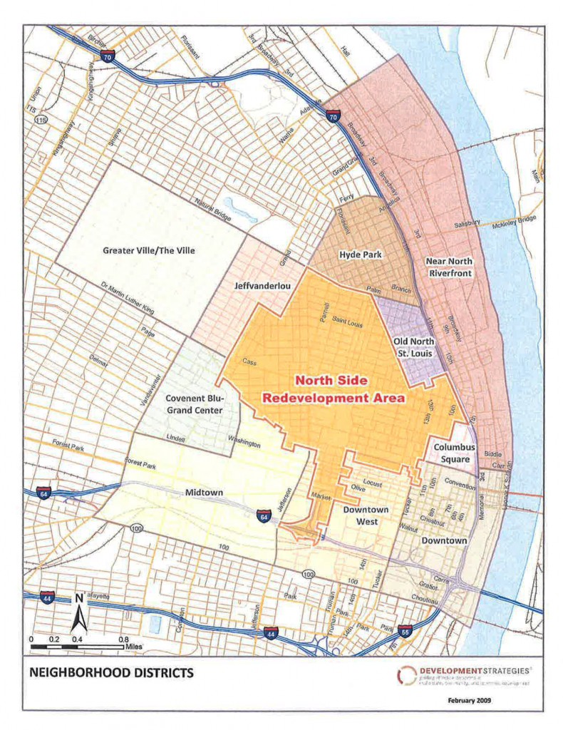
To start let’s look at the project area so we know where we are talking about:
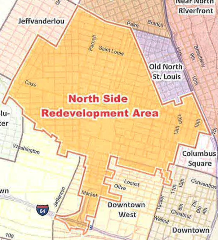
Here is the same image cropped to give you a close up of the proposed redevelopment area:
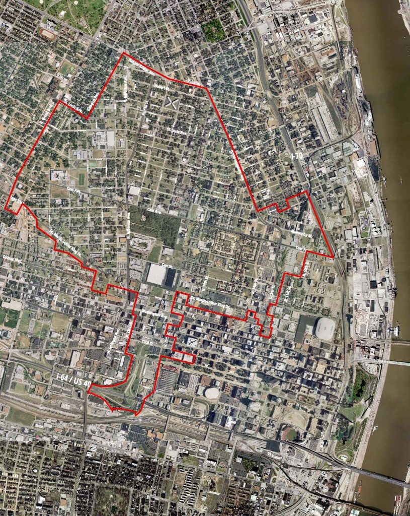
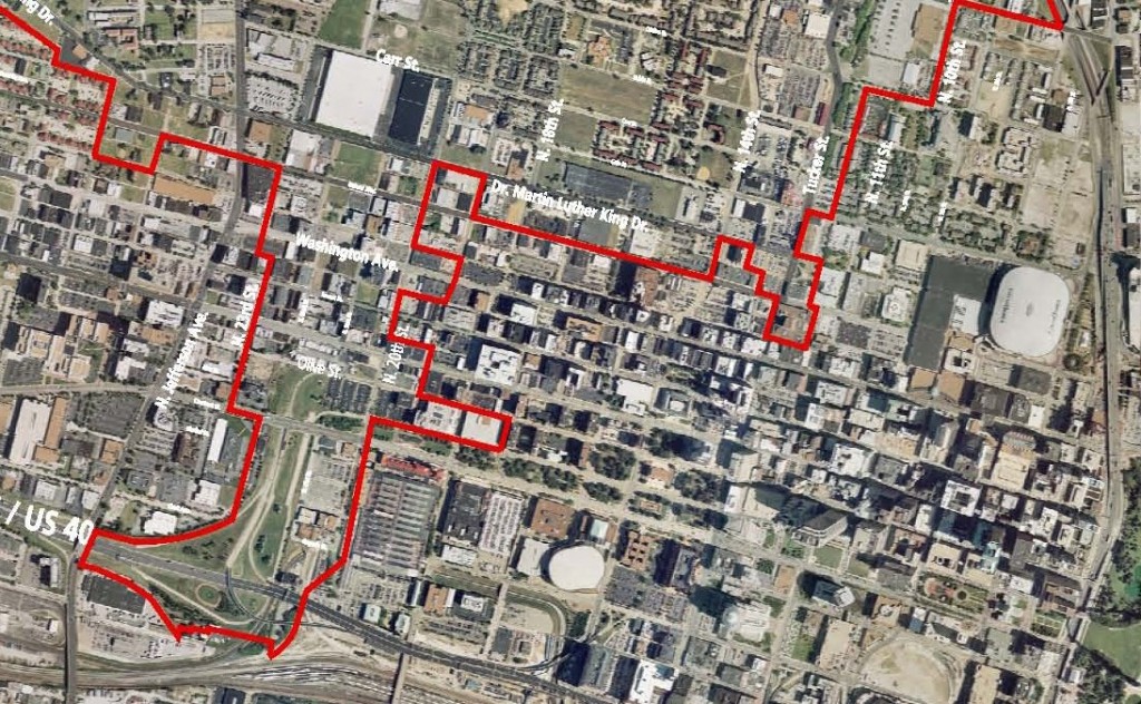
The carefully drawn boundary line includes some property but excludes others. Here is the boundary laid on top of an aerial image:
For at least a couple of decades now the city should have been doing some big picture planning (beyond a single ward) to figure out how to bring new life to this part of North St. Louis. But they didn’t. The Pruitt-Igoe site has sat vacant for 35 years. Old North St. Louis, adjacent to the project area, has taken decades (and plenty of tax credits) to get where it is today. Same for downtown and much of the city.
McKee’s plan calls for four job centers — large sites suitable for one or more companies to have a new campus setting. No surprise here, this is what McEagle does in suburban areas. This is a chance to get these jobs (and taxes) in the city. I was not able to obtain the image with the four marked sites so I have indicated them in blue below
Starting in the upper left and going clockwise we have Jefferson @ Parnell, where the new Mississippi bridge will land near Cass, the 22nd street interchange and finally in the middle left, the long-vacant Pruitt-Igoe site.
If we think about the process of redeveloping a large area you can do what Richmond Heights did with the Hadley Township area. Draw a boundary and put all the properties inside up for development proposals. Not surprisingly the residents there who’ve lived in flux while proposals came in picked not the best plan but the plan that would give them the most for their homes. After being in play for several years the owners were told the developer couldn’t come through. Same thing happened in Sunset Hills and elsewhere throughout the country. Often municipalities put areas up for development not because they are distressed but because they are chasing limited sales tax dollars. McKee has gone a different route. One based not on Ward boundaries but on where development potential exists.
While I love the rebirth happening in Old North St. Louis, without some serious infrastructure investment we’d not see much happening in the outlined development area.
“A tax credit for one man” is often heard about the Missouri Land Assembly tax credit written by McKee’s attorney. To be precise it is a tax credit for one company. But many companies will be involved. Others own land within and adjacent to the development area, including individual owners.
TIF financing will be used, no doubt, to fund massive improvements in public infrastructure, bridges, roads, sidewalks, sewers, etc. Will McKee & company make money? Yes, of course. We all need to make money. The question is if the outcome will justify the level of public investment. I hope so. I’m waiting to review the financing proposals. Remember that a “TIF” is tax increment financing. As property taxes rise due to the development that increment of increase is paid by the owner — yes, they pay the higher tax. That increment is used to pay off bonds used to build public infrastructure. Development & infrastructure are both needed here. The city doesn’t have the money to build the infrastructure to attract the development. McKee’s proposal may be the only way to redevelop this section of our region.
I am excited about the potential this project brings to the city & region. A chance to get some large new employers — or to retain the ones we’ve got. A chance to change perceptions about North St. Louis. A chance to fill in the many gaps in our building stock. A chance to add needed population. A chance to get a modern streetcar/trolley line connecting the project area to downtown. A chance to get thousands of parcels of land out of city ownership.
Before someone suggests I was bought off I can assure you I’m still a struggling grad student. I’ve met Paul McKee twice — the 1st time 3-4 years ago at a meeting of the Dardenne Prairie Board of Aldermen. The 2nd time was at McKee’s presentation last Thursday. This 2nd time he knew who I was and he offered his card. After a couple of emails I got the above images out of him, nothing else.
But while I like the big picture planning involved I have reservations about the follow through on the project. Paul McKee promised New Urbanism at WingHaven but delivered a half-assed cartoon version. The St. Louis Board of Aldermen, as a general rule with a few exceptions, do not get what compromises walkable urbanism. How will they know what to require of McKee? To be sure our old 1947 zoning needs to be tossed aside for this area. A new form-based code needs to be laid over the project area to guide future development to ensure we get what we are promised.
I want this project to succeed — financially & urbanisticly. I want to live along the trolley line. I want St. Louis to be a city of 500,000 people again in 20-25 years.
My intent for today was to summarize Paul McKee’s development proposal being dubbed ‘NorthSide.’Â In starting to write that piece it became clear I needed to build a foundation on the origins of the current problems in North St. Louis. So today I take you through decisions from the 20th century that got us to where we are and tomorrow I’ll give you my thoughts on McKee’s proposal.
North St. Louis has many great streets, buildings and people. But it has as many streets that are largely abandoned, buildings barely standing, vacant lots and criminally minded youth.  It is known more for the latter than the former.
Above: North St. Louis property in August 2007
When I moved to St. Louis in August 1990. at age 23, I was told not to go North of Delmar Blvd. — the long dividing line between white and black St. Louis. I ignored the advice, however well-intentioned, from the 50-something apartment manager and went North of Delmar. The following year I moved to the Old North St. Louis neighborhood. But how did this dividing line come to exist? For the answer we need to start way back in 1917.
Harland Bartholomew came to St. Louis in 1916, at age 27, after working briefly in Newark, NJ as an employee of civil engineers E.P. Goodrich & George Ford. Bartholomew was the first municipal planner in the country. Yes, St. Louis was the leading edge for planning at the time. Of course, planning as a profession was just getting started. The 1910 Census was 557,238.
Upon his arrival Bartholomew located his family in a relatively new house on Goodfellow near Page (map). Although within the city’s limits, it was very suburban relative to the older parts of the city near the Mississippi River. His 1917 report, The Problems of St. Louis, shows his dislike of the older sections of the city surrounding downtown.
Above: 1917 book, click to view book
From the above:
The problems of St. Louis are briefly as follows :
(1) Restoration of districts wherein values and occupancy are at a low ebb to a greater degree of usefulness and productivity.
(2) Perfection of transportation and transit systems to make possible the use of property within the zone of the city’s influence, now inaccessible,
(3) Extension of the city limits, or power of the city, to secure greater uniformity and permanency of development.
(4) Provision for public works and service sufficiently far in advance to preclude undue delay and excessive expense.
The problems then are still the problems today. Bartholomew spent the next 30 years telling the city how bad the older areas are. Bartholomew, for example, convinced voters to approve fund measures to widen many streets which involved cutting off the fronts of many buildings, see The History of the Ubiquitous Building Setback Line.  Jane Jacobs in her 1961 classic The Death and Life of Great American Cities called such funds “cataclysmic money.” The Census count was 772,897 by 1920, 821,960 by 1930 and, a down a bit to 816,048 in 1940.
In 1947 Harland Bartholomew, now nearly 60, authored the Comprehensive City Plan which considered much of the city, North & South, “obsolete” or “blighted:”
1947 "Obsolete" (black) & "Blighted" (red) map.
In the above image North St. Louis is on the right. Delmar runs top to bottom a bit right of center. Clearly much of the city, mostly white, was labeled obsolete & blighted. But what did that mean?
Obsolete Areas
Present obsolete areas must be cleared and reconstructed. This is a social necessity as well as an economic essential. The City of St. Louis cannot continue to thrive and prosper where there is nothing but progressive decadence in its housing supply, any more than is could with polluted water supply or smoke laden air.
The unit area for reconstruction must be the neighborhood. It is necessary to create a new environment. This can be accomplished only by large scale operations. Obsolete neighborhoods must be rebuilt, not merely with houses of good design and construction, but with more open space, more park and playground facilities, a good school and community center.
The new Constitution of Missouri authorizes cities to clear obsolete areas and to sell or otherwise dispose of the property, as well as to replan, reconstruct, or redevelop such cleared areas. The new Constitution also authorizes the General Assembly to provide by law for partial relief from taxation for not to exceed 25 years for projects designed for the reconstruction or redevelopment of obsolete areas. A newly enacted Urban Redevelopment Corporation Act now provides for substantial tax relief for reconstruction projects. It should make possible considerable large scale reconstruction.
The Legislature has not enacted legislation which will permit St. Louis to undertake public housing projects of the type heretofore financed with Federal funds. Such legislation is imperative if St.Louis is to participate, as do other American cities in any future Federal public housing programs.
Present high costs of building construction together with rent controls preclude immediate reconstruction of obsolete areas, either for public or for private housing. As construction costs become lower the city must be in a position to encourage wholesale reconstruction of these obsolete areas. This can be achieved by public acquisition of land so that it could be made available for housing and other needed purposes if private acquisition and construction fails to accomplish the needed results. The total cost of clearance would scarcely exceed public expenditure during the past 25 years for other types of public work such as streets, sewers and airports. Unlike these, however, ownership of the land would be a sound investment. The land could be leased or sold, and much if not all of the expense involved could be recovered by (1) elimination of the present $4,000,000 annual deficit, (2) a long-term increment in taxable revenues on private housing projects, and (3) participation in Federal subsidy programs.
Plate Number 15 is a suggested plan for reconstruction of two extremely obsolete neighborhoods-DeSoto and Carr Neighborhoods. This plan calls for reconstruction of these neighborhoods, except for the present Carr Square Village, into super residential blocks with a revised street system that would recognize this block type of development and discourage through traffic; Fourteenth Street, Eighteenth Street, Twentieth Street and Jefferson Avenue would be widened while Cass and Franklin Avenues would remain as they are. Further proposals call for the grouping of commercial areas into designated shopping centers; the erection of two or three story row type apartment buildings generally except for a few multi-story apartment buildings; the erection of two new schools one east of Jefferson and the other between 18th and 20th at O’Fallon; the continuance of certain unobjectionable industries, the enlargement of Carr Park adjacent to Carr School; the development of DeSoto Park for active sports, swimming and as a community center; the enlargement of Murphy Playfield adjacent to the Carr Neighborhood on the north and the provision for landscaped areas throughout the community for passive recreation.
The effectuation of this plan would result in a good standard of housing with ample open space, freedom from multiplicity of small streets, attractive environment, small concentrated shopping areas, and a large neighborhood park and community center would replace one of the worst slums in the city. This is an area occupied by low-income families, many of whom should be rehoused here.
Plate Number 16 is a plan for the reconstruction of the Soulard Neighborhood. Some of the more important features of the plan are: the extension of Gravois Avenue from Twelfth Street to the proposed Third Street Interstate Highway, providing a direct route to the central business district; the widening of 18th Street, the widening and extension of 14th Street, the widening of Park and Lafayette Avenues; underground garages in the multi-storied apartment area between 12th and 14th; a neighborhood part of 10 acres or more complete with spray pool, community facilities and game courts; the extension of Lafayette Park to serve this as well as other neighborhoods; landscaped areas throughout the community for passive recreation; enlargement of the City Hospital area; grouping of commercial areas into orderly shopping centers and the complete reconstruction of the neighborhood into super residential blocks with a new street pattern to serve these blocks and to discourage through traffic.
Such a plan would transform an obsolete area into a fine residential neighborhood with a good standard of housing, enlarged open areas, greatly improved environment, small concentrated shop centers, and much needed park and recreation space. The new interstate highway passes diagonally through this neighborhood and could be most advantageously undertaken simultaneously with the reconstruction. This is an area well suited for families of medium incomes.
The plan sought to clear and reconstruct a vast area. It had nothing to do with race – these areas were largely white. It had everything to do with Bartholomew’s inability to see any value in these older areas.  Blighted districts, Bartholomew thought, didn’t need clearing but he clearly wasn’t a fan:
Blighted Districts
The blighted districts should be extensively rehabilitated before they degenerate into obsolete areas. This is both a social need and an economic essential because of high rates of juvenile delinquency, crime, and disease found in areas of poor housing.
Rehabilitation of blighted districts must be undertaken on a neighborhood basis also in order to protect environment and to create improved living standards. Because of the larger areas involved, special planning and experimentation is required. Obsolete buildings should be removed, some streets should be closed, new park, playground and recreation areas created, small concentrated shop areas established, and individual buildings should be repaired and brought up to a good minimum standard. The new Constitution of Missouri specifically provides for this type of rehabilitation. There is fully as much opportunity for private enterprise in this field as in the more spectacular large scale reconstruction housing projects.
The most important single requisite for the improvement of housing in St. Louis is the enactment of a Minimum Standards Housing Ordinance. The City Plan Commission, the Building Commissioner and the Health Department with the aid and assistance of the American Public Health Association, have collaborated in the preparation of such an ordinance which provides for:
1. Elimination of overcrowding by prescribing minimum standards of space per family and per person.
2. The number, area, and openness of windows permitting entrance of fresh air and natural light.
3. Screens on doors and windows to restrict flies and mosquitoes.
4. Elimination of basement rooms as dwelling units unless they comply with the provisions set forth in the ordinance.
5. Improvement of sanitary conditions by elimination of hopper water closets and privies in sewered areas within six years of effective date of ordinance.
6. The location of water closets and the number of persons using them.
7. Keeping dwelling units in a clean, sanitary, habitable condition and free from infestation.
8. Maintenance and repair of dwellings necessary to provide tightness to the weather and reasonable possibilities of heating.
9. Installation of flues which would permit the operation of heating equipment to maintain adequate temperature in each habitable room.
10. Adequate daylight or fixtures for artificial illumination in public halls bath rooms and other habitable rooms.
Unless and until such an ordinance has been adopted and enforced, most housing areas in St. Louis will continue to deteriorate and blighted districts and obsolete areas will reach much greater proportions than at present.
The rehabilitation of blighted areas is the No Man’s Land of housing. It is more important than reconstruction of obsolete areas. It is a field that has been completely neglected partly because it is less spectacular than large scale reconstruction and partly because the opportunities for profitable investment are presumably less than in a new development. Without a definite plan for the rehabilitation of the present blighted areas new obsolete areas will develop faster than present areas can be reconstructed. Plate Number 17 illustrates the manner in which neighborhood rehabilitation should be undertaken.
So the message was clear in 1947, these areas were going to change. The 1947 plan added to the pressure for whites to move to the suburbs. Soon race would be another.
At the time most of these areas were off limits to non-whites. Blacks had few choices about where to live. One choice was The Ville, located in North St. Louis:
The Ville is not St. Louis’ earliest Black community, but it is certainly the most cherished. When elder Black folks talk of their old St. Louis they remember the area bounded by Taylor Avenue, St. Louis Avenue, Sarah Street and what is today called Dr. Martin Luther King Drive. Though embattled with middle-class flight to the suburbs, underemployment, and other ills, it remains a close-knit community of churches, schools, social institutions and residences. Fortunately, the Ville was never dominated by high-rise public housing. (Source: Soul of America)
At the same time much of the city, where blacks still couldn’t live, was being set up to be cleared or rebuilt. But soon blacks would be able to move beyond a few areas like The Ville:
In 1945, a black family by the name of Shelley purchased a house in St. Louis, Missouri. At the time of purchase, they were unaware that a restrictive covenant had been in place on the property since 1911. The restrictive covenant barred “people of the Negro or Mongolian Race” from owning the property. Neighbors sued to restrain the Shelleys from taking possession of the property they had purchased. The Supreme Court of Missouri held that the covenant was enforceable against the purchasers because the covenant was a purely private agreement between the original parties thereto, which “ran with the land” and was enforceable against subsequent owners. A materially similar scenario took place in the companion case McGhee v. Sipes from Detroit, Michigan, where the McGhees purchased land subject to a similar restrictive covenant. The Supreme Court consolidated the two cases for oral arguments. (Source: Wikipedia)
The Shelley house is in the 4600 Block of Labadie (map), just a block outside of The Ville. In 1948 the U.S. Supreme Court, in Shelley v. Kraemer, agreed that restrictive covenants are private agreements but state enforcement of them violated the 14th Amendment to the Constitution.  Blacks were now legally free to buy where they pleased. Easier said than done. More on that in a bit.
By 1949 Congress passed the Housing Act of 1949 that funded large scale “Urban Renewal” schemes like those envisioned by St. Louis’ Bartholomew and New York’s Robert Moses.
Bartholomew predicted by 1970 St. Louis' population would pass one million and we'd live in newly rebuilt high density housing.
The 1950 Census was St. Louis’ peak at 856,796. In the next 20 years (1950-1970) the population didn’t pass the million mark as Bartholomew had predicted. Instead it fell 25% to 622,236. Real Estate agents in these decades engaged in blockbusting and steering. They determined which streets, blocks and neighborhoods would quickly shift from all white to all black. And although some whites live North of Delmar and some blacks lived South of Delmar the dividing line was established.  North St. Louis has come to be viewed by all as black. As time marched on white flight was followed by black flight, leaving North St. Louis with fewer total residents, more and more who were poor & black.
Many public housing projects were built on the near South side & near North side. The most well known was Pruitt-Igoe, which opened in 1955. In 1956 the Pruitt (black) – Igoe (white) project became integrated.
Above: Pruitt-Igoe (click to view Wikipedia article)
Within a decade the 2,870 apartments were only 2/3rd occupied. In March 1972 the first of the 33 buildings were imploded with all being demolished within two years. Planned as the type of project to rebuild a former Polish slum, Pruitt-Igoe didn’t last 20 years.
The RAND Urban Policy Analysis Program released 3 reports on St. Louis in 1973 including St. Louis: A City and Its Suburbs: By: Barbara R. Williams. The following is the official summary:
A summary statement of the research findings and policy implications of a series of studies conducted under the St. Louis project of the RAND Urban Policy Analysis Program. Three possible futures for the city are posed: continued decline; stabilization in a new role as an increasingly black suburb; and return to a former role as the center of economic activity in the metropolitan area. The analysis argues that without major policy changes beyond the local level, the city will most likely continue to decline, and suggests that, among the alternatives open to the city, promoting a new role for St. Louis as one of many large suburban centers of economic and residential life holds more promise than reviving the traditional central city functions. However, new resources, available to the city from sources outside the city, are essential to any improvement. Several mechanisms are offered for consideration: (1) a more substantial federal revenue-sharing program; (2) a state revenue-sharing program to support selected public goods; (3) a metropolitan revenue program, sharing revenue generated by industry in the metropolitan area; and (4) a metropolitan earnings tax.
In response local firm Team Four was hired to look at the problems facing the city:
This document contains the technical memorandum that was submitted to the Plan Commission by Team Four, Inc. in 1975. This memorandum proposed public policy guidelines and strategies for implementing the Draft Comprehensive Plan that was prepared by others. It offered a series of considerations concerning the process of adopting, staging, budgeting and ultimately implementing the Draft Comprehensive Plan. In addition, this document contains a preface dated 1976 that attempts to clean up any inconsistencies and or controversies surrounding the proposed implementation strategies and a bibliography or annotated listing of Technical Memoranda and Appendixes. Part I of this document focused on strategies for three generic area types: conservation, redevelopment, and depletion areas; and Part II of this document discussed major urban issues and their solutions. (Source: Summaries of Historical Planning Documents, City of St. Louis)
This last document will forever be known as the “Team Four” plan. It called for a triage approach to the city. Letting areas that are too far gone to die, focusing resources on areas that could be saved. Increasingly this meant white areas would get help and black areas would not. The Team Four plan was never officially adopted but many feel it became the unofficial policy of the city. Bartholomew’s 1947 Comprehensive Plan was the last city-wide plan adopted.
The city basically stopped trying to any planning. People continued to leave. By 1980 the Census count452,801. In 1990, the year I moved to St. Louis, the Census count dropped below 400K to 396,685.
By the time the plan was adopted by the Planning Commission in March 2002 the boundaries of the 5th Ward had changed as a result of the 2000 Census (now at 348,189). No regulatory changes were made in the planning area to ensure the plan would be followed.
In 2005 the city adopted a new Strategic Land Use Plan. But the old zoning and land use designations remained unchanged. New more thoughtful & appropriate ideas alluded to in this new land use plan never materialized. We remain stuck in 1947.
The decline of North St. Louis goes back farther than anyone reading this blog post. St. Louis basically stopped trying to plan their way out of decline — perhaps the best option. Tomorrow I’ll look at the plan by Paul McKee to reverse this long trend.
Thursday night Paul McKee gave a presentation on the project he has been acquiring property for and planning for 5 years.
Paul McKee on 5/21/09
The poll this week asks about your current level of trust with McKee and his company McEagle Properties. I’ll have a post on my thoughts about the project on Tuesday morning. For a preview tune in to KDHX 88.1FM at 7pm CST Monday May 25th. For online options ckick here.
I’ll have a full report next week on McEagle Developments vision for North St. Louis but I wanted to put out one tidbit today. They indicated a desire to create four job centers where large companies could relocate. One of the four is currently the site of a highway interchange for a highway that was never built, the 22nd street interchange for the 22nd street parkway that was to go around the West edge of downtown. That was the vision in the early 20th Century. The highway has been dead for years but the interchange at I-64/highway 40 exists. I fully support reclaiming this land. I talked about the idea several years ago when reviewing ideas for the West end of the Gateway Mall. I last blogged about the idea in December 2008 in the post MoDOT Needs To Put The 22nd Street Interchange On Any Wish List For Funding. So go back and read that post & comments again so you’ll be up to speed when I mention it again next week as part of my review of Paul McKee’s plan for St. Louis’ North Side.
Tonight we expect politically connected developer Paul McKee, of McEagle Development, to publicly unveil the controversial development project nicknamed “Blairmont.”
The project got this name after one of the early holding companies used to acquire properties, Blairmont Associates LLC.
Here is a video that explains Blairmont:
Another source of info on Blairmont is a January 2007 RFT article.
Out of the controversy came an August 2007 bus tour of McKee’s properties. Here is 5th Ward Alderman April Ford Griffin:
The next month the meetings continued. Here is 19th Ward Alderman Marlene Davis:
I got involved by asking a question of Alderman April Ford Griffin. Griffin is the chair of the Neighborhood Development committee at the Board of Aldermen. She has a warped view of zoning. Rather than have excellent zoning that codifies the community vision, she likes outdated zoning so developers must come to her. The video starts out rough but gets better:
Congressman Clay talks about a hearing held at city hall with a reference to the 1970s Team Four plan that called for reducing services in parts of the city:
This document contains the technical memorandum that was submitted to the Plan Commission by Team Four, Inc. in 1975. This memorandum proposed public policy guidelines and strategies for implementing the Draft Comprehensive Plan that was prepared by others. It offered a series of considerations concerning the process of adopting, staging, budgeting and ultimately implementing the Draft Comprehensive Plan. In addition, this document contains a preface dated 1976 that attempts to clean up any inconsistencies and or controversies surrounding the proposed implementation strategies and a bibliography or annotated listing of Technical Memoranda and Appendixes. Part I of this document focused on strategies for three generic area types: conservation, redevelopment, and depletion areas; and Part II of this document discussed major urban issues and their solutions.
Today “shrinking cities” are studied and various techniques are debated. In the 70s in St. Louis the Team Four plan was seen as a racist plot to deny services to a minority population. We know more today about how to adjust to shrinking populations.
Tonight we will see another, a huge heavily subsidized redevelopment plan. Many are opposed simply based on the history of the project to date. I for one plan to go with an open mind. I have reservations about both the developer and the political leadership. Griffin’s view on the role of zoning doesn’t give me a lot of hope for what may be presented in pretty artist renderings actually being completed as promised. A good framework of a zoning code can help ensure the promised vision develops into reality.
Tonight’s meeting starts at 7pm at Central Baptist Church Education Building 2843 Washington Ave (Google Map). I’ll be there and will report on the presentation next week.
AARP Livibility Index
The Livability Index scores neighborhoods and communities across the U.S. for the services and amenities that impact your life the most
Built St. Louis
historic architecture of St. Louis, Missouri – mourning the losses, celebrating the survivors.
Geo St. Louis
a guide to geospatial data about the City of St. Louis