Home » NorthSide Project » Recent Articles:

Transit-Oriented Planning Eliminates 22nd Street Interchange, Reconnects Street Grid

For years I’ve been accused of being a naive dreamer, coming up with big plans without the existing market to implement. I’ve just smiled and continued sharing my long-term vision for St. Louis.

In June 2007 I wrote:

The 22nd Street Interchange, part of an abandoned highway concept from a few decades ago, needs to be ripped out with the land returned to active tax-paying use. The Missouri Dept of Transportation (MoDOT) should rework the interchange at Jefferson Ave to allow for on/off ramps in both directions and therefore eliminating the need for the current ramps at 22nd. MoDot could sell the land to fund the revisions to the highway ramps. (St. Louis Should Abandon Linear Gateway Mall Concept)

Then in December 2008 I wrote:

I picture a new bridge at I-64/40 and Jefferson Ave — one with a single point urban interchange (SPUI) and both East & West on/off ramps. Build that and then remove the 22nd interchange completely. Bring in form-based zoning codes to require a denser urban environment. Make a strong connection through the back of Union Station (between the shed & highway) so that pedestrians from this newly developable land have the opportunity to walk to Metrolink and the 14th street transit station beyond that. The fact that much of this area is already excavated and free of utility lines would simplify the construction of underground parking in new buildings. (MoDOT Needs To Put The 22nd Street Interchange On Any Wish List For Funding)

By May 2009 I noted that St. Louis’ 22nd Street Interchange Part of McKee’s Plan so it elimination would need to be worked out with him. Presumably MoDOT agrees with McKee because they’re replacing the Jefferson bridge over I-64/40 with no plans for on/off ramps to/from the east.

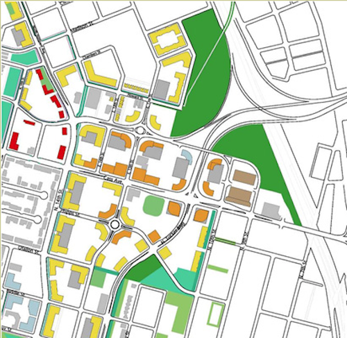
Then, last month, at an St. Louis Regional Transit Oriented Development Study presentation around the Union Station & Civic Center Metrolink stations the Denver-based consulting firm suggested largely what I had outlined years earlier.
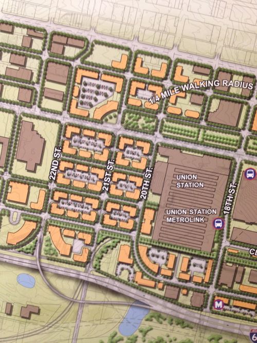
Preliminary plan around Union Station, the Drury (former YMCA) and other existing buildings should be shown in the final presentation.

Ok, they still have on/off ramps for I-64/40 to the east, but they are compact and feed into the reconnected street grid I had advocated. The above image is preliminary, I pointed out it was missing buildings like the Drury Inn on 20th, formerly a YMCA and later a gay bar/hotel/bathhouse. Hopefully their final will be more accurate than the draft shown at the last meeting.

Still they see what I and others saw, the need to repair the street grid and fill in the gaps in the urban fabric.
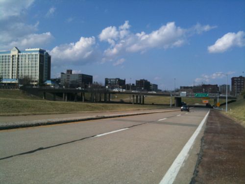
Only part of a planned highway loop around downtown was built, a huge waste of land to the west of Union Station.
The 22nd Street interchange is just on/off ramps.
1958
1958 aerial of the area west & north of Union Station

This is not about trying to recreate the buildings and feel of the area prior to the demolition for the highway interchange. This is a forward-looking vision to create a walkable/urban environment for those interested in such. Some prefer the look & feel of new buildings, new sidewalks, new trees, etc. This is an opportunity to create an entirely new neighborhood largely from scratch yet have access to existing transit.

Per McKee’s plans, a few new employers could anchor the neighborhood. Workers & residents would attract restaurants, dry cleaners, and other services.

None of this is rocket science, it’s Urban Planning 101. St. Louis still needs lots of basics to rebuild the connections that were ripped out in the 20th Century.

— Steve Patterson
 

McKee’s Northside Regeneration Moving Forward

As you’ve likely heard by now, last week the Missouri Supreme Court overturned a 2010 ruling that Paul McKee’s Northside Regeneration development plans were too vague for TIF financing:

After over 3 years of litigation, developer Paul McKee’s controversial Northside Regeneration Project is being allowed to proceed.  On Tuesday the Missouri Supreme Court reversed a lower court decision blocking McKee’s use of so-called “Tax Increment Financing,” (TIF) for the development. (St. Louis Public Radio)

I’ve never been thrilled about how McKee handled property acquisition and maintenance, but I recognize the city’s total absence of planning and working toward a common vision left an opening for private interests without public input.

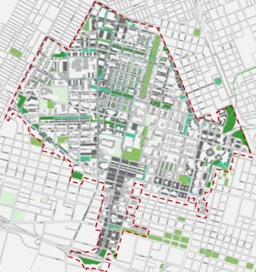
Original outline of McKee’s Northside Regeneration project

The project area is large but it’s a fraction of the city as a whole. There are many other parts of the city, north & south, dealing with continued population decline, increases in vacant buildings, and other signs of decay. Where’s the people upset the city isn’t doing anything to solicit public input in the rest of the city? Transportation, housing, jobs, education, etc are all being ignored.

The Jaco report just had Paul & Midge McKee on taking about their project, see the video here.

One of the biggest issues is the massive TIF (tax increment financing) package for the project. What needs to be understood is the pros and cons of the TIF tool. When a municipality invests in new infrastructure in stable and up & coming areas few tend to object since people see the value of improving desirable locations. Conversely, this means declining areas don’t see improvements in public infrastructure (sidewalks, roads, sewers, lighting, etc).  Both are self-fulfilling in that rebuilding public infrastructure in the sable/improving areas further helps these areas while the lack of infrastructure investment in others accelerates decline in others.

Begin replacing sidewalks & lighting in sparsely populated declining neighborhoods and people will quickly question the return on that investment.  This is where the TIF tool come in, a private developer agrees to invest in a blighted area and pay much more in property taxes than the municipality currently collects but only in part of that tazx is used to pay off bonds used to rebuild the public infrastructure the municipality can’t afford to rebuild otherwise.

The developer needs the new infrastructure to attract investors/buyers/tenants but the municipality can’t rebuild the infrastructure without a way to pay for it. The municipality can’t risk existing revenues to pay off bonds to rebuild the infrastructure so that means new revenue must be used.  Sales taxes are a bad source for these revenues

  • Residential & office development don’t pay sales taxes
  • Sales taxes would take too long to accrue
  • Our sales tax rate is already sky high

This leaves property taxes as a source of revenue. To simplify things say the property is paying $100/year in property taxes but after redevelopment the property taxes will now be $200/year. With the TIF the municipality/school district would still collect the $100 it always did, $5o (increment) would go to pay off infrastructure bonds and the remaining $50 would go to the municipality/school district. Do nothing get $100/year or do the project and get $150/year.

The actual numbers will be different but you get the point: public infrastructure gets rebuilt, building happens, more taxes are collected than if nothing happened. This is a simplified view and there are cons such as favoritism for the developer(s), risk of pushing out good people, etc.

My concern is St. Louis won’t require good urbanism such as strong pedestrian connections. The infrastructure needs to be rebuilt and TIF is the best way to do that, but we need to have a say on characteristics of the final development.

— Steve Patterson


McKee & MoDOT To Announce Plans To Complete A Revised 22nd Street Parkway

At a news conference at 1pm this afternoon MoDOT and Paul McKee will announce a revised plan for the long-stalled 22nd Street Parkway. The following is based on confidential materials I viewed briefly.

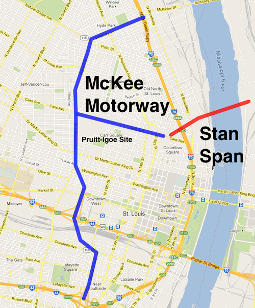
The blue represents new highway, to be called the McKee Motorway. Red is the new bridge under construction.

As part of the plan:

  • The resurrected 22nd Street Parkway will be connected to I-44/I-55 by replacing Truman Parkway
  • Ameren Electric will build a new headquarters on the former Pruitt-Igoe site, the old HQ will be razed to make room for the highway.
  • It would bend over and replace Jefferson/Parnell & Salisbury and connect with I-70.
  • A connecter will replace Cass Ave to reach the new bridge.
ABOVE: Only part of a planned highway loop around downtown was built, a huge waste of land to the west of Union Station.

From the embargoed press release:

“The solution to redeveloping north St. Louis is having much more highway frontage” said developer Paul McKee, “plus the new McKee Motorway way will serve as a divider to keep unwanted types out of my development area.”

Of course I’m opposed to this plan! Do they think we are fools?

— Steve Patterson


3519 Page Blvd

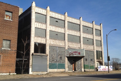
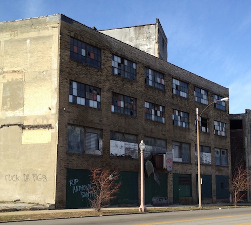
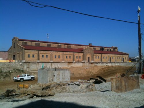
The vacant 4-story warehouse building at 3519 Page Blvd is a favorite of mine, it was built in 1909.

ABOVE: Beautiful detailing on the Page Blvd facade
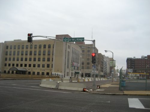
ABOVE: The simpler rear elevation of 3159 Page faces MLK Dr

The building and it’s 1926 neighbor to the west are owned by NorthSide Regeneration LLC, Paul McKee’s project. Hopefully this building will be renovated into office or residential space.

 – Steve Patterson


Downtown’s New Entrance

Downtown St. Louis can be reached via car from all directions. None is particularly a nice drive, although I do like entering from Illinois via the Eads Bridge. When the New Mississippi River Bridgeopens in 2014 motorists on I-70 from Illinois and west of St. Louis will have a new option, an exit that takes them to Cass Ave and directly onto a new alignment of Tucker Blvd into downtown.

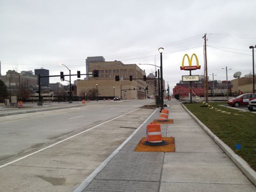
ABOVE: Facing south toward downtown on the new Tucker Blvd

A short stretch of the rebuilt Tucker recently opened to traffic. I’ve had a chance to drive it twice and walk part of the sidewalk. It’s too early to do a review of the design of the road & sidewalks but so far it looks good with only a few problems I’ll note in a later post once more is opened.

ABOVE: Tucker after the old road, a bridge over a railroad tunnel, was removed

The good is the road is only two lanes in each direction. Rather than have three per direction with the outside used for parking or buses, the third lane isn’t a through lane. Space is provided for buses and parking but the road doesn’t feel excessively wide the way say Jefferson does between Olive & Natural Bridge. New new road, median, planted areas at the edges and street trees will make a great first impression. But when motorists look past the new sidewalks they will likely be disappointed by what they see. Great buildings like the one above, instead of housing retail storefronts, has the city’s Mosquito & Rat control division, aka Vector Control. Welcome to St. Louis!

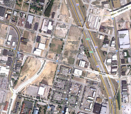
ABOVE: Aerial image of the new Tucker (lower left) and bridge approach (upper right)

Most of the land is vacant — empty or surface parking lots as you near Washington Ave. Right now the only planning that’s been done is via Paul McKee’s Northside Regenerationplan:

The Missouri and Illinois Departments of Transportation are working together to construct a new bridge that spans the Mississippi River just north of downtown St. Louis. The new bridge has the potential to become both a catalyst for the revitalization of the area in the immediate vicinity of the “landing” and a new entrance into downtown St. Louis. For the catalytic effects of the new bridge to be fully realized, transportation improvements are needed in the area around the bridge ramps beyond what MoDOT has planned for their 2011 construction. McEagle has been working with the City of St. Louis and MoDOT to create a more efficient flow of traffic into the downtown and NorthSide areas from the new bridge. Along with the new N. Tucker Boulevard alignment planned to begin construction in spring 2010, McEagle has proposed two additional off ramps to the MRB interchange and a new Mullanphy Street realignment and bridge over the MRB Landing (MRB Extension). This Extension will provide a direct connection for west-bound traffic to the NorthSide as well as provide an alternative route for eastbound traffic to access the MRB interchange. The development yields for this area have been projected as follows:

  • Office/Business space: 860,000 sq ft
  • Retail: 173,000 sq ft
  • Residential: 2019 units
  • Hotel: 120 rooms

Regardless of your views on Paul McKee’s project you have to give him credit for recognizing the opportunity to develop new housing, offices and retail.

ABOVE: The following message popped up when I went to save this image from the source: "Since we are still in the early design phases of the project, we ask that you please not copy our images yet since these designs are not final." For my purposes here it shows that planning is being done.

I’m still concerned the new buildings will lack connections to adjacent sidewalks. St. Louis now has a “Complete Streets” policy, but no requirement for adjacent properties to connect. The ADA requires minimal connection but a building can be built and occupied without it, leaving enforcement up to those who complain. If we take McKee, and his consultants, at their word the area will be pedestrian-friendly. My preference, of course, would be a requirement by ordinance. Former 5th Ward Alderman April Ford-Griffin never would initiate such a requirement and I don’t expect any of the three woman running to fill the vacant seat to do so either. The election is December 20th. Good or bad, McKee has the Tucker & Cass area under control. But what about south of Biddle St? The 1986 McDonald’s was just razed and replaced. The new one does have an ADA access route from one of the four streets bordering the property, but it’s still a prototype  best suited for a suburban/rural highway exit.

ABOVE: The east side of Tucker has the Post-dispatch, St. Patrick's Center & the Globe building, but the west side has parking and a gas station and little else. 2009 photo.

The west side of Tucker needs urban buildings up to the sidewalk, like they are on the east side.

ABOVE: Globe-Democrat building at Tucker & Delmar (aka Convention Plaza)

This is one of those opportunities that doesn’t come along often. Will we step up and take the necessary actions to ensure Tucker develops right over the next 20-30 years?

– Steve Patterson


Advertisement


[custom-facebook-feed]

Archives

Categories

Advertisement


Subscribe