Five years ago I suggested 9th & 10th Streets through the Columbus Square neighborhood (Cole to Cass) be uncoupled so that both are two-way streets again. See Columbus Square: 9th & 10th Streets from May 19, 2014.
In short, 9th & 10th have been a one-way couplet (opposite directions) to facilitate vehicular travel between I-70 and downtown — passing through the Columbus Square neighborhood. Due to the construction of the Stan Musial Veterans Memorial Bridge 9th/10th hasn’t connected to I-70 in 8-9 years. Yet, these excessively wide one-way streets remain through the neighborhood.
What has changed in the last five years?
I moved to the neighborhood nearly 5 months ago and 9th Street immediately south of Cole Street will close if the convention center is expanded. Living here, frequently crossing 9th & 10th, I can tell you they’re substantially wider than necessary. Being wide and one-way their design encourages drivers to travel at much higher speeds than should be in a residential neighborhood.
Five years ago the main obstacle to correcting this problem was the cost to alter/replace 3 traffic signals. The possible convention center expansion project includes significant changes to Cole Street — including new signals at 9th & 10th. That leaves only the relatively new signal at 9th & Cass to modify — minor work since 3 out of 4 approaches is currently two-way. Some additional stop signs will be necessary at intersections between Cole & Cass.
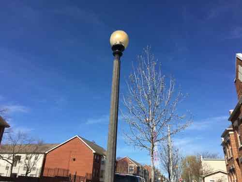
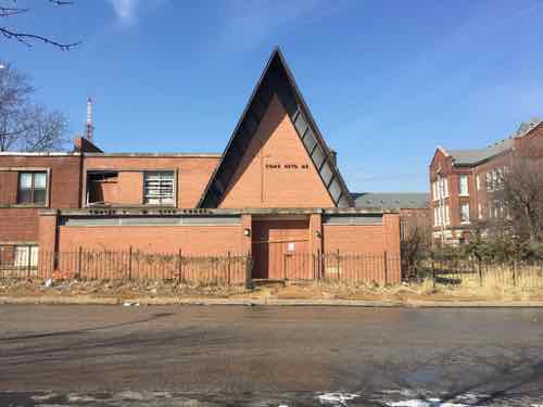
Looking North on 9th Street toward Cass. It’s 44 feet from curb to curb.
We measured the width of 9th & 10th in various places five years ago, 9th @ Manhattan Place (south of Cass) was a very wide 44 feet. For comparison, Locust at 16th is a much busier street and is 42 feet wide. You need 8 feet for each parking lane, plus a max of 12 feet for each travel lane — a total of 40 feet. I’d prefer 10 or 11 foot travel lanes. There’s no money to physically narrow the streets, but a wide center “median” could be painted with stripes.
This pair of streets should’ve been returned to two-way during the 2010-2013 bridge project, but they weren’t. With the convention center project closing 9th and altering Cole, we’ve got another opportunity to correct the problem of one-way highway access streets through the center of a neighborhood — with an elementary school in between.
May 13, 2019Environment, Featured, NeighborhoodsComments Off on Neighborhood Streetlights Still On Because Electrical Station Is Blocked
A month ago I posted about how My Neighborhood’s Street Lights Are Always On. To get this resolved I sent the link to the blog post to the folks at the St. Louis Citizens Service Bureau (CSB). As always, the promptly responded.
Here’s one of the many images of street lights on during the day included on my April 12th post.
These lights are supposed to be pedestrian-scaled are also used frequently throughout the neighborhood. Many have the globe canted like this one. Carr at 8th
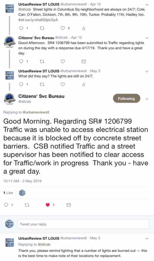
The CSB said lighting department was to respond by April 17th. On May 3rd the lights were still on so I replied asking what’s going on.
Click above to view the thread on Twitter
Yes, the lights have been on in my entire neighborhood for months (years?) because a concrete barrier is blocking access. I went searching to see if I could figure out the location of the blocked access to the electrical station.
Manhole cover at 6th & Carr Streets. This might be the blocked electrical station
I”m not sure the above is the blocked location in question. In September 2014 it’s partially covered, and more so in August 2017. Another nearby cover remains accessible.
Again, I don’t know if this is the correct location for the neighborhood electrical station workers need to access to get the street lights to come on only at night. All I know is the street lights, except the ones that are burnt out, remain on 24/7 a month after I notified the city.
Unfinished house on 22nd Street in the Hyde Park neighborhood, August 2016
Following a recent daytime shooting Ald. Brandon Bosley started a long-overdue conversation about taking back neighborhoods from criminal elements.
The boldness of the crime, on a sunny spring day as sports fans flocked downtown, just three miles south, led the neighborhood’s alderman to call for deployment of the Missouri National Guard before the summer hits and crime spikes.
“I’m done waiting,” said Alderman Brandon Bosley of the 3rd Ward. “Before it gets too bad, we need to do something measurable. Extra hands. Extra guns. Guns bigger than the ones on the street.”
Bosley said he and the city Board of Aldermen’s black caucus had been talking for weeks about petitioning Gov. Mike Parson. He said he hoped to persuade the board to pass a resolution calling on Parson to send troops to the worst city neighborhoods. (Post-Dispatch)
The conversation took place on Twitter after Post-Dispatch writer David Hunn sent out the following tweet about the story:
I read through some of the replies, many good points made. In general I don’t like the idea of military forces being brought in. On the other hand, though I do live in North St. Louis, I’m not in a neighborhood that’s experiencing the violence that a few areas are. I get it, Bosley and residents want something done. Now!
Maybe the Missouri National Guard is the answer, maybe not. I’ve said before a lot of our problems are long-term, requiring long-term solutions. Correcting inequalities would help, but that will take many years once started. Understandably, Bosley wants action before it gets hot out.
I wish I had the answer.
Here are the results of the recent non-scientific Sunday Poll:
Q: Should Gov. Parsons send the Missouri National Guard to help patrol the worst neighborhoods in the City of St. Louis?
Definitely not!: 11 [33.33%]\
No: 7 [21.21%]
Hmm, don’t think so: 3 [9.09%]
Neither yes or no: 1 [3.03%]
Hmm, I suppose: 4 [12.12%]
Yes: 5 [15.15%]
Definitely yes!: 2 [6.06%]
Unsure/No Answer: 0 [0%]
A clear majority oppose the idea of the National Guard.
A Doug Unplugged segment on the subject, not online at this time, missed the point entirely. KMOV’s DougVaughn liked the idea, saying the National Guard should be outside Cardinals games, etc. Bosley isn’t arguing for military to make suburbanites who venture downtown for a game to feel safe, he’s trying to help the people in his ward feel safe in their neighborhoods
As previously posted, we moved to the Columbus Square neighborhood at the end of December. Since I’ve been looking into the history of the neighborhood, a challenge since much of the pre-WWII structures have been razed and replaced.
Today’s post is an introduction to the four properties within the neighborhood boundaries that are listed on the National Register of Historic Places. These are listed below in the order they were added to the register, the date is shown at the end. The text for each is from their nomination to the register, click heading for each to view PDF (files are very large).
St. Joseph’s last month, the antique car was out front due to a wedding taking place inside
The Shrine of St. Joseph is important to St. Louis as a building of great aesthetic value and as a monument to the Jesuits and their powerful role in the history of the Archdiocese· and the City of St. Louis.
Of the churches built in Baroque revival style, St. Joseph’s is one of two remaining in St. Louis. Neo-Baroque, popular with the Jesuits throughout the nation during the nineteenth century, had origins in the Tridentine Catholicism of the Counter Reformation.
In the 16th and 17th centuries the Church introduced a series of reforms that stressed the parish, regular Sunday attendance at Mass, an increased number of devotional activities, the creation of lay confraternities, and so on. Revived in the mid-1800’s this style of worship sunk deep roots in the urban neighborhoods of German and Irish Immigrants. It was the religion of three generations of American Catholics.
The parish of St. Joseph’s, established in 1845 for the German-speaking Catholics of the near north side, grew out of a small immigrant community who settled near St. Louis University and worshipped at St. Aloysius Chapel, the College Hall of the Jesuit University. These newcomers were among the first arrivals of massive waves of European immigrants who would transform a steamboat town of around 16,000 in 1840 into a cosmopolitan commercial center with a population of 160,000 by the outbreak of the Civil War.
The cornerstone of the Roman Catholic Church of St. Joseph’s was set by Bishop Kenrick of St. Louis on April 14, 1844 on land donated by Anne Mullanphy Biddle, daughter of John Mullanphy and widow of Major Thomas Biddle. “…a great concourse of people, including the Hibernians, came for the cornerstone laying…” The church was completed by a volunteer labor force made up of parishioners. On the fourth of August of 1846, Father James van de Velde, S.J., later Bishop of Chicago, dedicated the building.
Immediately, the parish became the center of the community. Schools and an orphanage were established for the young and the Jesuits turned their attention to intense missionary work. In 1846 the Bureau for German Immigration was organized by Father Hafbauer, S.J. in order to attract immigrating Germans to Missouri’s Jesuit settlements. Father Seisel, S.J. served as editor of ”Herald des Glaubens”, St. Louis’ first German Catholic paper. Three parishioners organized the parent organization of the nationally important German Roman Catholic Central Society (Katholische Central Verein) in 18540 Another school, the first St. Louis installation of the Sisters of Notre Dame, was sponsored that same year.
The south side of Neighborhood Gardens earlier this month
The Neighborhood Gardens Apartments located on City Block 558 (bounded by O’Fallon, North 7th, Biddle and North 8th Streets) near downtown St. Louis qualifies for listing in the National Register of Historic Places under Criteria A and C and is eligible under the following areas of significance: ARCHITECTURE: Completed in 1935 from plans drawn by the St. Louis firm of Hoener, Baum & Froese, Neighborhood Gardens is an excellent example of Modernistic domestic architecture. Although knowledgeable in the latest developments of International Style European housing projects, the designers and client chose materials associated with the fine local brick vernacular traditions. It is the imaginative handling of this brickwork combined with a thoughtful site plan and skillful layout of the apartments which give the project a durable distinction even more evident today than when it was constructed. COMMUNITY PLANNING: Neighborhood Gardens is a testimony to the dedica tion of a Settlement House’s efforts to demonstrate that low-rent housing could be well- designed and financially sound. The Association’s commitment to excellence is reflected in the Board’s support for a study of exemplars in Europe as well as financial contributions to assure that the project would be built. Dedicated to the premise that physical environment influences behavior, the Association was a pioneer in the attempts to rebuild American inner cities.
The Sligo Iron Store Co. complex is located just north of downtown St. Louis, Missouri on a triangular shaped parcel of land bordered on the south by O’Fallon Street, on the west by N. 7th Street, and on the north and east by Interstate 70 (formerly N 6th Street). Constructed primarily between 1902 to c. 1940, the Sligo Iron Store Co. complex is comprised of five buildings, four of which are contributing. The contributing buildings include all buildings historically associated with Sligo: five-story Main Office and Warehouse (1906), two-story Garage (1903 with 1923 alterations) and its one-story addition (c. 1940), two-story Machine Shop (1902 with c. 1917 alterations), and the five-story 7th Street Warehouse (1911). While constructed over a 40-year period, the contributing buildings share a common vocabulary of building materials and represent the prototypical construction techniques common in the early 20′ century. In 1959, a 2-story functionally unrelated Sporting Goods Factory was constructed to the north and that building was subsequently incorporated into the Sligo parcel. The Sporting Goods Factory is non-contributing due to its date and its construction for a functionally unrelated use.
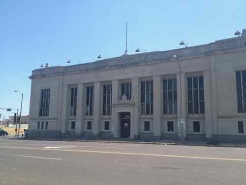
Constructed in 1927, the Cass Bank and Trust Building at 1450 N. 13th Street, St. Louis (Independent City), is a two-story Neo-Classical Revival style building sheathed in smooth limestone with a granite veneer base. On the primary (west) façade, monumentality is clearly emphasized by a dominating colonnade of eight squared Tuscan columns supporting a minimally embellished entablature. Recessed between the columns are large metal nine-light windows. Centered in the colonnade is a slightly projecting entrance topped by a cornice and elaborate crown featuring stylized stone eagles. The entablature consists of a plain architrave, frieze with bas relief medallions and a cornice lined with cylindrical guttae. The colonnade is flanked by two slightly projecting end blocks with tripartite division. The base contains three centrally grouped metal windows with a large twelve-light metal window in the shaft. The entablature is similar to that in the colonnade but with a more decorative frieze. In 1964, the bank constructed a raised concrete and brick addition for offices and drive-thru lanes. The upper two stories have inset bands of tall, narrow windows set in limestone surrounds. Though the addition is a modern design, the building’s two primary decorative elevations and the interior banking hall with its elaborately chamfered ceiling, classical plaster relief work and its colossal Corinthian columns are essentially unaltered since its date of construction.
February 18, 2019Featured, Neighborhoods, North CityComments Off on Worst Property in Columbus Square: 1127 North 9th Street
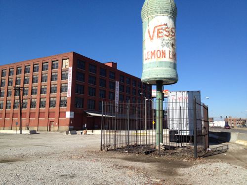
I’ve lived in the Columbus Square neighborhood for nearly two months now, one property stands out at the worst. To the casual observer passing by on I-44, you might think it’s the vacant warehouses/lots on the neighborhood’s eastern edge owned by Paul McKee’s Northside Regeneration.
The Vess bottle in 2012, before being repainted. The McKee-owned warehouse in the background has since had a fire.
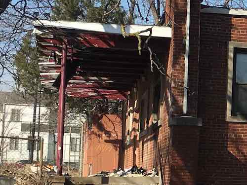
Nope, the worst property in Columbus Square is right in the center, next to a public school. Surrounded by nice residential properties.
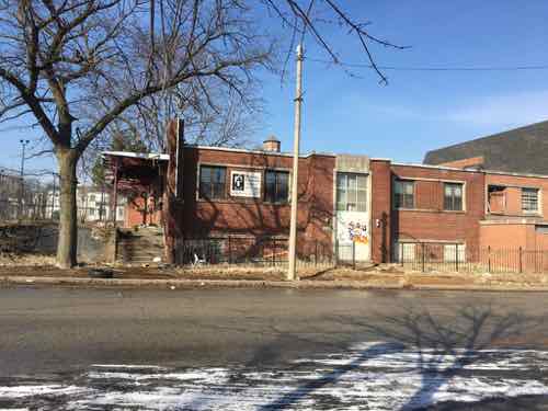
City records list this property as 1127R North 9thA cropped version showing the poor condition on the SouthThe Northern portion is a different brick color, presumably built later (between 1958-68 based on review of historicaerials.com). Patrick Henry Elementary school can be seen on the right.
I wanted to lookup the owner and contact them, but it wasn’t that simple. The address listed in the caption above — 1127R. The ‘R’ means rear. The city website shows a 10′ deep x 235′ wide parcel in front of this. The front parcel is owned by the LCRA — the city’s Land Clearance for Redevelopment Authority.
The property at the rear, which contains the building, is owned by a corporation called Ribbon Cutter, Inc. Their address is listed as 217 E Greystone Ave Monrovia, CA 91016, a gorgeous single-family home that just sold for $1.85m. I’m sure the new owners will be surprised when they get an unpaid tax bill for 1127R North 9th Street St. Louis MO in the mail.
Searching the Missouri Secretary of State for ‘Ribbon Cutter’ we get three listings:
Neither S. Broadway address appears to have any connection to Michael Thomas. However, the former is owned by an LLC not listed by Missouri, the latter is owned by an LLC in California.
The two limited liability companies have another address: 30 Santa Clara #D Arcadia CA 91006, Google Maps says this is the address for American Healthguard Corporation, a dental insurance business.
So I’m putting this post out today hoping someone knows why A) the city owns a 10′ deep strip of land in front of this derelict building, and B) the whereabouts of this particular Michael Thomas. I’m also curious about the building’s history, the address is also listed as 1111 N. 9th St.
AARP Livibility Index
The Livability Index scores neighborhoods and communities across the U.S. for the services and amenities that impact your life the most
Built St. Louis
historic architecture of St. Louis, Missouri – mourning the losses, celebrating the survivors.
Geo St. Louis
a guide to geospatial data about the City of St. Louis