Regular readers know I’m a supporter of public transit, and an advocate for modern streetcars, in particular. When I received an email from a planning student asking about publishing her paper on her evaluation, I was curious. Here’s how Jill Mead described herself to me in that email:
I’m a Masters in Public Health and Masters of City Planning student at the University of North Carolina in Chapel Hill. I also work for the Pedestrian & Bike Info Center at UNC’s Highway Safety Research Center. If that weren’t enough, I’m very much a St. Louisan. I grew up in Forest Park Southeast (in the 80s!) and am a K-12 graduate of the SLPS. I went to UMSL for one year and Wash U for the rest of my college degree.
Though I don’t agree with her analysis and conclusions in the paper, I thought it would spur some good discussion. Here is a brief summary of her paper:
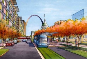
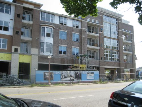
Artist rendering of proposed streetcar in downtown St. Louis.
Spurred by the availability of federal funds and inspired by the success of streetcar projects in other cities, the non-profit Partnership for Downtown St. Louis released a feasibility study for a downtown St. Louis streetcar project in March 2013. The feasibility study recommended the project based on its likelihood of achieving its two main objectives: (1) enhancing the region’s transit system and (2) catalyzing economic growth throughout the streetcar corridor. While the St. Louis Streetcar Feasibility Study is optimistic about the achievement of these two objectives, reviewing the study calls some of their claims into question. Ridership estimates seem inflated given the slow travel speeds of the streetcar and methodology used. The choice of alignment fails to prioritize the city’s densest areas and is out of sync with plans being made at the regional level. In terms of the streetcar’s ability to catalyze economic development in St. Louis, the study inadequately addresses the wide variety of contextual factors, such as land use policy and the existence of strong public-private partnerships and market demand that were characteristic of other cities’ success in attracting development to streetcar corridors. The paper concludes that strategies to improve economic growth and public transportation are necessary in St. Louis, but it is not clear that the proposed St. Louis Streetcar project is the best use of public resources to achieve these goals.
When St. Louis University announced plans to move their law school from midtown St. Louis to downtown, the Partnership for Downtown St. Louis once again began the discussion of a streetcar for downtown. This move presented an opportunity to link the two campuses with a streetcar and fulfill the goals of the Downtown Next Plan.
The idea of SLU running shuttle buses every day between midtown and downtown meant only a small segment of the population would be served, pollution would increase, roads would be see additional traffic from the continuous loop of shuttles. Us regular transit riders along Olive/Lindell would still have 30-40 minute headways on the existing #10 MetroBus. Why not improve the public transit system for all?
Connecting to south St. Louis wouldn’t help SLU with transporting students, faculty, and staff between the main campus in midtown and the new law school building downtown. By including a north-south segment on 14th the proposal recognizes future expansion into south & north city.
The existing MetroBus isn’t slow, it doesn’t take me long to get to the Central West End from my downtown loft, but the streetcar will come every 10-15 minutes instead of every 30-40 minutes — that’s far more important than whether it takes 8 minutes versus say 12-15 minutes to reach my stop! The streetcar will be faster than the bus, the center dedicated right-of-way, off-board fare payment, etc. will make the trip no longer than bus, very likely shorter. Buses are sometimes late; they get stuck in traffic, wheelchair lifts malfunction, rerouted around events, etc. When the bus takes 10 minutes to get to my stop but arrives 10 minutes late that puts me way behind. If I take the 30 minute earlier bus I arrive way too early and it uses more of my day.
Also from page 2 of the final study:
The purpose of the study was to:
support the goals established in The Downtown Next 2020 Vision to improve Downtown’s accessibility;
create a catalyst for continued economic development;
provide additional opportunities for alternative transportation;
support the region’s and City’s sustainability initiatives;
and promote an environment that will retain and attract new jobs and residents to the City.
I’ve invited Mead to come downtown and ride the #10 MetroBus with me, to midtown and back, to better understand the existing conditions, then I think she’ll see how the streetcar will be a potentially massive improvement. She’s in town visiting family, we’re talking about doing this later in the week.
Mead is correct when she said, “the study inadequately addresses the wide variety of contextual factors, such as land use policy.” The word “zoning” appears just four times in the final study report. “Proper zoning” is mentioned, but not defined. My fear is we won’t set up the necessary land-use controls to guide new development over the 10-20 years following the completion of the streetcar. If the prevailing Laissez faire attitude in St. Louis is allowed to squash good form-based zoning then the streetcar investment will be at least partially wasted.
But if we can get the formula right, it will be a boon and expansions can follow every few years, as we’ve seen in other cities. But I’ve been here long enough to know the old guard isn’t going to change so easily. Will this time be different?
Please share your thoughts on Mead’s paper, or my response, below.
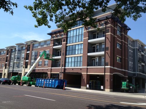
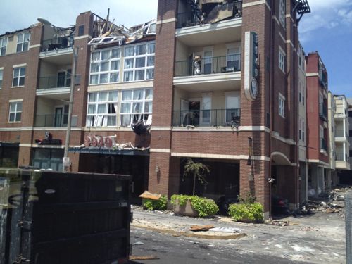
A year ago the 3949 Lindell Apartments were a burt out mess, but now they’re nearly rebuilt.
Just over a year later the rebuild is nearly complete.As seen on July 19, 2012 passing by on the #10 MetroBus
Looks like the same basic design, with some details being different. Notably, the large windows are now have black frames rather than white.
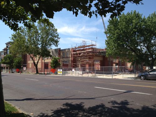
Immediately to the east a new CVS is under construction.
CVS tried to raze the former offices of the St. Louis Housing Authority a half a block to the west and later they wanted to raze the round AAA building, they were rebuffed at both sites. They wanted a store in this area so they were forced to adapt. AAA has also announced they will renovate their building since they were denied a demolition permit.
With the CVS being built on the AAA parking lot the former lawn is now parking.Pedestrians had a path from the sidewalk to the front door, but now the lawn is now auto parking. Hopefully they plan a new pedestrian route when construction is complete.
Once all three are finished I’ll visit to see how they connect to the sidewalks on Lindell and McPherson, as well as to each other.
Rarely does the “unsure/no answer” option go unselected in the weekly poll, but last week the voting was higher than usual with 145 total votes and everyone had an opinion about their favorite commercial street in St. Louis. Here are the results:
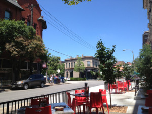
The intersection of Euclid & McPherson in the CWE
Q: Pick your favorite commercial street in St. Louis city
Euclid (CWE) 32 [22.07%]
Grand (South Grand) 25 [17.24%]
Delmar (Loop) 23 [15.86%]
Cherokee Street 20 [13.79%]
Washington Ave 17 [11.72%]
Other: 11 [7.59%]
Manchester Ave (The Grove) 8 [5.52%]
Morgan Ford 5 [3.45%]
Locust St (Midtown Alley) 3 [2.07%]
N. 14th Street (Old North) 1 [0.69%]
Unsure/No Answer 0 [0%]
As I said in the post introducing the poll, I’m thrilled there are so many choices.
In hindsight I should’ve 1) noted I meant a commercial street with organized marketing effort 2) defined what a commercial street is and isn’t, 3) allowed 2-3 selections rather than just one, and 4) included a few of the ones below submitted by readers:
DeMun Neighborhood West of Clayton
Ivanhoe
Macklind
manchester ave
the Loop and South Grand tie for me
Castleman Circle (Shaw & Vandeventer)
Manchester (Maplewood)
Gravois
Mackland
Truman Parkway
Hampton Avenue
Ivanhoe & Macklind are the two I wish I had included. DeMun is an interesting area…in Clayton, not the city. Interestingly nobody added say 2nd Street in Laclede’s Landing.
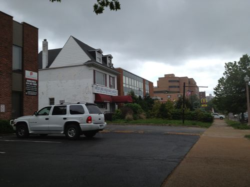
How did Euclid in the CWE edge out South Grand, Delmar Loop, and Cherokee? Probably a number of factors but the main one is likely the first mover advantage. It was Euclid Ave that convinced me to move to St. Louis in 1990, at the same time the other streets were nothing like they are today.
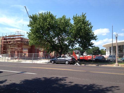
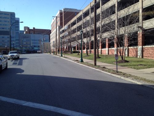
As I’ve done for the last month, this is another post on potential development sites along the proposed initial route of the St. Louis Streetcar. The sections already reviewed are as follows:
This post continues west to the end of the first phase of the route, starting at Lindell & Vandeventer to Lindell & Taylor, south on Taylor to Children’s place at the BJC hospital complex and next to the Central West End MetoBus Transit Center & MetroLink station (map).
Longtime readers know I’ve advocated a modern streetcar line for years connecting Downtown, Midtown/Grand Center, Central West End, and the Loop. My preferred route was to go north on Vandeventer then west on Delmar. I’d still like to see a streetcar on Delmar. Other options to go north from the current proposed route are at Sarah and/or Taylor. I’d like to see a decision made about future expansion so the track can be added onto without disrupting the Lindell route.
Anyway, here’s a look going west from Vandeventer:
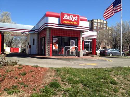
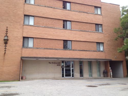
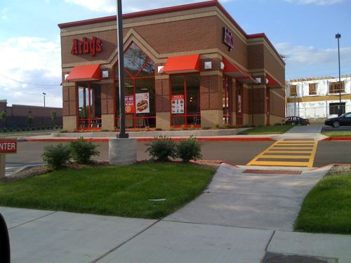
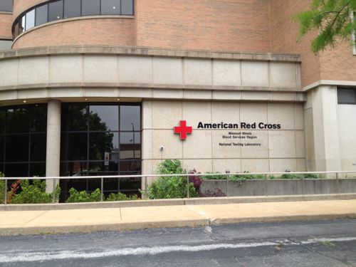
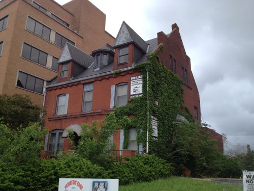
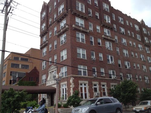
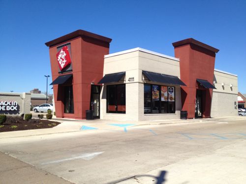
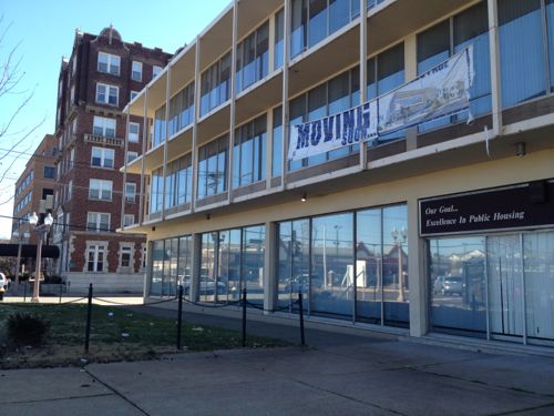
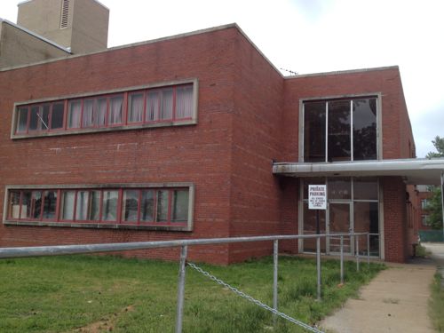
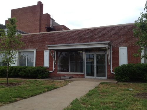
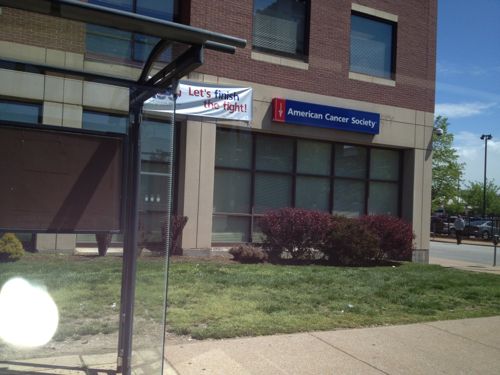
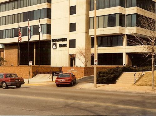
This Rally’s was built in 1993 on nearly a third of an acre site with streets on three sides (Lindell, Vandeventer, & McPherson. The land & building are owned by a firm in San Diego, CA. Given the short life expectancy of such a structure I’d expect a more urban building on this site in the first 5 years of the streetcar line.Next door the American Automobile Association of Missouri is renovating their iconic former headquarters building. CVS is building a drugstore on the west end of the site.The apartments at 3949 Lindell are being rebuilt after a 2012 fire, this is an August 2008 photo. More development of this scale will become the norm along the route, it’ll be a 10-20 year process, not overnight.A number of buildings occupy smaller lots on the south side of Lindell, these do a poor job of connecting with the sidewalkThis McDonald’s was built in 2008 on a site that is nearly an acre. McDonald’s owns the site so I wouldn’t expect to see a change for 20-30 years unless the land value increases dramatically and drive-thru sales collapseThis building, The Continental, was built in 1965. City records indicate it has 49 apartments. Density is good but it isn’t welcoming. New facade? Raze & replace?The Arby’s on Lindell, built in 2007, is also on nearly an acre siteThis American Red Cross building has good mass & density, but a poor relationship with the public sidewalk, typical for 1966.The former mansion at 4054 Lindell was built in 1896. It appears to be in decent condition so perhaps it’ll get a new owner or be razed for something more urban.The apartment building at 4066 Lindell, built in 1927, has 68 apartments. As is it provides affordable units, but renovation to go upmarket is possible, displacing low-income tenants in the process.The part of Lindell Marketplace on the east side of Sarah sits on 4.8 acres. The will get razed & redeveloped into a dense mixed-use site before the larger site to the west due to fewer tenants to inconvenience.With three outlots included, Lindell Marketplace on the west side of Sarah has 9.3 acres. It is bounded on all sides by public streets, built in 1986. Multiple ownership, anchor tenant Schnucks, and many small tenants complicate redevelopment.This Jack-In-The-Box at 4111 Lindell, built in 2011, occupies one of the three outlets.CVS wanted to raze the former Public Housing Authority building at 4100 Lindell but there was opposition. Hopefully it’ll get a nice renovation that respects the original 1957 design. I picture a ground floor restaurant with a lush patio out front, offices or apartments 0n upper floors.The 1948 building next door is more likely to get replaced than renovated.4158 Lindell is from 1948 but I see no reason why a developer shouldn’t raze it and build a mixed-use building. The Leonardo Apartments to the west is on a smaller lot and contains 34 apartments.The Walgreens at 4200 Lindell was built in 2002 on a massive 1.8 acre site. I see this as being a perfect location for Walgreens’ new upscale urban flagship format, complete with a fresh sushi bar, in a multi-story mixed-use building. Click photo for article about this new format.I’d like to see the American Cancer Society lease part of their ground floor to activate the NW corner of Lindell & Whittier StThis one-story branch bank was built in 1995 when SLU bought & razed the branch at Lindell & Grand. The site is 0.75 acres.In 2009 the San Luis Hotel was razed for a parking lot. Hopefully we’ll eventually see a new building on this siteThe Boatman’s Bank on Lindell in 1990-91, now a Bank of America, is very disconnected to Lindell.The NE corner of Lindell & Euclid was built in 1968. A high-rise was planned for this site when the economy crashed.The SW corner of Lindell & Euclid has been a parking lot for 20+ yearsThe parking lots on the east side of Kingshighway should also be considered for developmentThe west end of phase 1 would be next to the open air CWE MetroBus Transit CenterThis street would be the initial west end point, nearly zero development potential unless you’re willing to raze a garage built in 1994
There’s much more development potential here than I originally thought, but with mixed-use projects like 3949 Lindell and the planned City Walk (with a Whole Foods) it could be argued the streetcar is needed in other areas to get development rolling.
Future installments in this series will look at:
Development potential in the downtown central business district
Some challenge/changes the streetcar will create
And a poll(s) on routes for future expansion
Still, I’m excited by the transit the streetcar could provide as well as the level of development it could spur.
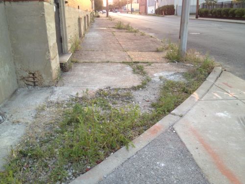
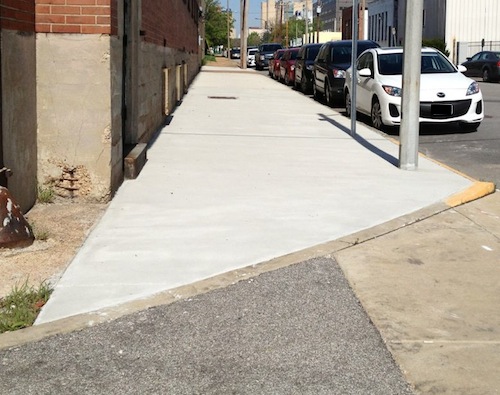
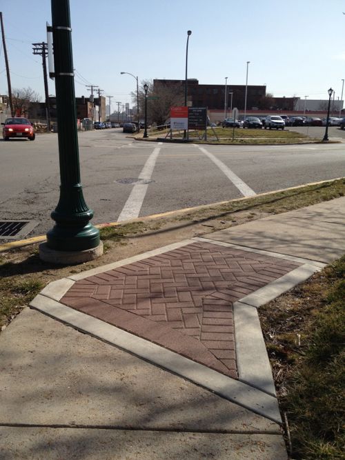
Today when I visit Solae it won’t be a challenge like it has been, last month I discovered a problem that existed since the building opened in 2008 has finally been fixed. Last July I posted about the problem and contacted Solae, Cortex and Washington University.
Here’s what it used to look like, the gap was nearly impossible to navigate:
Photo from July 2012 post: Solae’s contractor left a wide gap between old and new sidewalk on Duncan
It was suggested in the comments on my post last year that the adjacent building (shown above) owner was responsible. I rejected that idea because it was the construction work at Solae that created the gap that caused the problem. The architect and/or contractor didn’t consider patching the area where they had to over dig.
Now the sidewalk is passable.
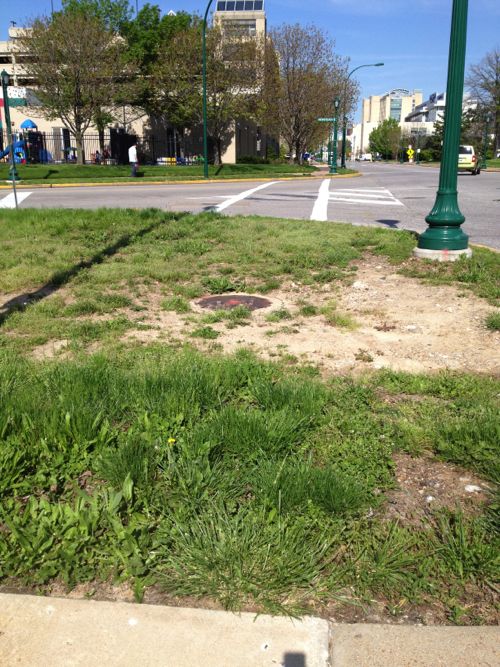
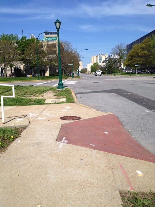
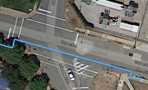
Unfortunately, my trip from the Central West End MetroBus Transfer Center/MetroLink Station still has a major access problem. At Duncan & S. Newstead (map) I can’t use the crosswalk to cross Newstead.
The crosswalk exists but only if you can walk through grass and down a curb, then jump a curb on the west side of Newstead.Stepping back we can see the nearest ramp which id designed to cross Duncan, not NewsteadThe blue line shows the route I take to cross NewsteadThe opposite view shows one of the many decorative stamped concrete inserts Washington University added throughout their medical campus district to enhance the pedestrian experience. Feb 2012 photo.
Washington University spent considerable time and money on these decorative inserts, seemingly without thought to the functionality of the pedestrian network. This infuriates me beyond words. The money spent could’ve been used to make the area accessible and the sidewalks wide enough so when you meet someone they don’t have to step off the sidewalk into the grass. These decorative inserts are the type of pedestrian improvements are designed to look good on paper and driving by.
Can you imagine if roads were designed for aesthetics rather than function?
We’ll see how long it takes before I can use the crosswalk.
AARP Livibility Index
The Livability Index scores neighborhoods and communities across the U.S. for the services and amenities that impact your life the most
Built St. Louis
historic architecture of St. Louis, Missouri – mourning the losses, celebrating the survivors.
Geo St. Louis
a guide to geospatial data about the City of St. Louis