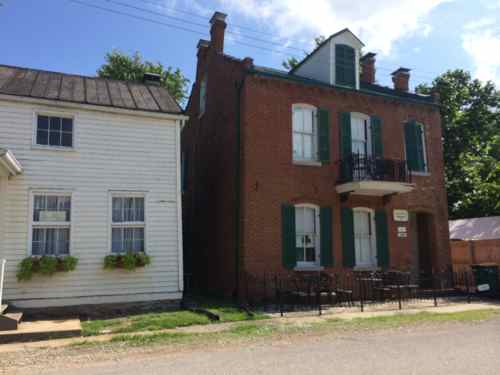
New Solar Carport At The Centennial Malt House Located At 2017 Chouteau

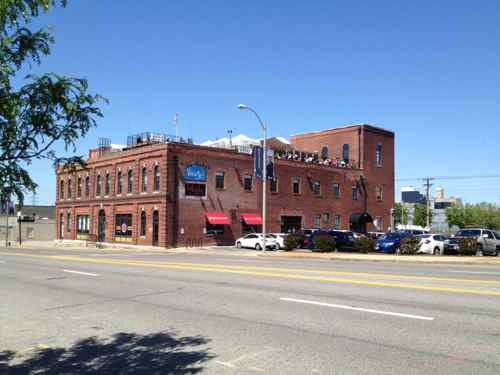
The building at 2017 Chouteau, known as the Centennial Malt House, was built in 1876 as part of the  Joseph Schnaider Brewery complex.

Merged with the St. Louis Brewing Association in 1889, Schnaider’s brewery was shut down within a decade. The Chouteau Avenue Crystal Ice & Storage Plant occupied several buildings; other property including the garden was razed for the enormous International Shoe factory. Eventually, the malt house was relegated to use by a truck parts company. Things looked pretty grim when Wendy and Paul Hamilton, owners of the nearby 1111 Mississippi restaurant, purchased the property in April 2005. Faced with a tight timetable, Paul and his restaurant staff spent many extra hours working alongside an army of contractors led by Spiegelglass Construction Co. Office space under construction on the first floor is already leased; the rooftop bar and bistro Vin de Set should open this June. National City Bank plus federal and state historic tax credits financed the $4 million mixed-use project designed by Tom Cohen. (Landmarks Association 2006 Most Enhanced Award)

To make renovation financially viable the building was listed on the National Register of Historic Places in 2005. Since the Hamilton’s opened Vin de Set they’ve added PW Pizza, Moulin Events, Grand Petite Market, and the Malt House Cellar. They opened Eleven Eleven Mississippi nearby in 2003.

In April 2012
The Centennial Malt House at 2017 Chouteau before the carport was built, April 2012 photo

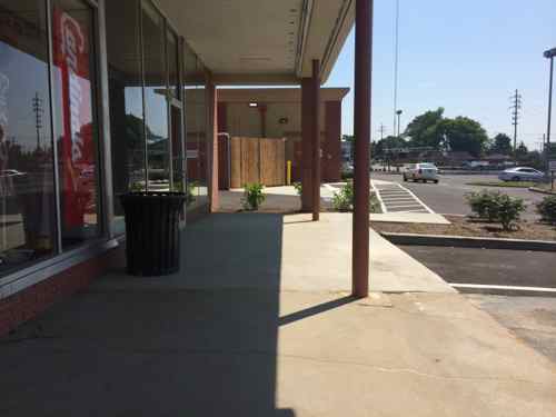
When I was there a few months ago for the 6th Ward Participatory Budget Project Expo I had no idea a solar carport was planned, it was a pleasant surprise upon arriving for dinner on Saturday.

View of the carport in the center of the small parking lot
Looking down from Vin de Set's rooftop
Looking down from Vin de Set’s rooftop
Looking toward downtown you can see Ameren's headquarters, the solar carport is at the bottom
Looking toward downtown you can see Ameren’s headquarters, the solar carport is at the bottom

From a year ago:

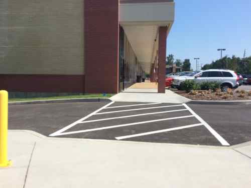
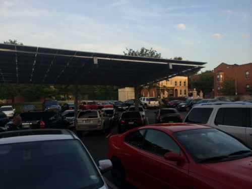
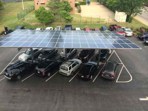
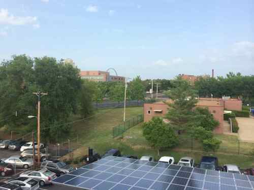
Hamilton and his wife, Wendy, are investing $98,000 to have solar energy panels installed near the Centennial Malt House at 2017 Chouteau Ave., built in 1876, which houses Vin de Set, PW Pizza and Moulin Events. The 25-kilowatt, photo-voltaic system is expected to be complete by September.
As part of the project, the Hamiltons are installing a solar carport canopy on the east portion of the restaurant’s parking lot. The panels will be adjacent to Ameren Missouri’s headquarters at 1901 Chouteau, and Hamilton said Ameren will purchase excess power generated by the canopy. (St. Louis Business Journal)

Like most projects, it took longer to complete than originally planned. I like how, over the 9 years since they bought the building, they’ve added little by little to utilize the large building.  Missouri’s Historic Tax Credit Program saved an otherwise unsalvageable building, creating many jobs and tax-generating businesses.  The Solar Investment Tax Credit, Ameren rebates, etc made this project possible.  Two tax credits working as intended!

— Steve Patterson


Accessing Yorkshire Village Shopping Center

In March I took MetroBus out to the suburban Yorkshire Village shopping center to meet my then-fiancé, now husband, for lunch. I hadn’t been in this area since I sold my car and the Sappington Farmers Market closed, both in 2012. Although the parking lot had been improved with planted islands in the last decade, I didn’t think a pedestrian access route existed. I’d looked at an aerial and at Google’s Street View, but I know for sure after a personal visit.

Google's Street View in March 2014 showed a spot where I could access the parking lot from the bus stop, no designated route. Click image for map link
Google’s Street View in March 2014 showed a narrow spot behind the bus shelter where I could access the parking lot, no designated route though. As of today the aerial is updated to show demolition of the old corner, the Street View remains the one I saw in March. Click image for map link

Based on a friend’s recommendation, we planned to meet at a newish place called Fuzzy’s Taco Shop, located on the far west end of the shopping center. When I arrived on March 21st what I encountered was very different than what I had expected, the entire corner of the old shopping center was gone, with a new building going up.

View from the bus stop
View from the bus stop, my only option was to head to Laclede Station to try to enter that way.
The construction zone separated the two wings, preventing me from reaching my destination that way. I ended up rolling along the Watson Rd shoulder until reaching an auto drive.
The new building is a CVS. Disclosure: we'd bought a small number of shares a month earlier when they announced they'd stop selling cigarettes.
The new building is a CVS. Disclosure: we’d bought a small number of shares of CVS a month earlier when they announced they’d stop selling cigarettes.
After lunch I got as close as I could to the construction, wondering if they'll provide an access route to the bus stop, connect the new separate buildings.
After lunch I got as close as I could to the construction, wondering if they’ll provide an access route to the bus stop, connect the now separate buildings.
When I passed by the new entry while on the shoulder I didn't see any evidence of a public sidewalk or access route to the shopping center
When I passed by the new entry while on the shoulder I didn’t see any evidence of a planned public sidewalk or access route to the shopping center
Across Watson waiting for a return bus you can see the overview.
Across Watson waiting for a return bus you can see the overview, and a pedestrian walking on the shoulder as I had to do.

It’s the suburbs and during construction everyone will be inconvenienced. My husband returned to Fuzzy’s a couple of times since our initial visit, after he said construction was completed we decided to meet again on Friday July 11, 2014. What would I encounter?

Looking west there was no public sidewalk along Watson
I was so pleased to see a proper access route, in concrete to contrast with the asphalt paving!
Looking inward I was so pleased to see a proper access route, in concrete to contrast with the asphalt paving! The planter helps to protect the route from vehicles.  Bravo!!
I quickly checked and found a great connection to the north building across the drive through lane
So I head west alongside the new CVS. so far so good.
And a connection to the west...but what's that I see?
And a connection to the west…but what’s that I see?
A new curb!?!
A new curb!?! Not sure who’s fault this is: engineer/architect, contractor, or owner, but someone screwed up an otherwise adequate access route.
I had to roll behind 13 parking spaces to reach a ramp, one car nearly backed into me.
Looking back from in front of the shops you can see the new concrete, this could've easily sloped to provide access.
Looking back from in front of the shops you can see the new concrete, this could’ve easily sloped to provide access. Again, nobody caught the mistake.

Had it been done right initially the cost would’ve been zero, no different than what they spent.  Did the drawings show it correctly but the contractor missed it? Why didn’t Webster Groves’ inspectors catch it? I can’t answer these questions but I’ll be emailing a link to this post to Matthew Stack at Koch Development Co and Webster Groves, the various parties can figure out who’s responsible for the costs to bust out the new concrete and redoing it correctly.

Koch Development originally built Yorkshire Village shopping center in 1951.

— Steve Patterson


Poll: What Are Your Two Preferred Methods To Deposit A Check Into Your Checking Or Savings Account?

Please vote in the poll, located in the right sidebar

Banking has changed throughout the years, changing cities along the way. Every so often a new technology has come along that has changed the way we bank which go to thinking about methods of depositing manual checks (vs direct deposit of paychecks). The weekly poll question for this week is: You’ve got a check to deposit into your checking or savings account, pick your two preferred methods.

The poll is to the right, the answers provided will appear in random order for everyone. I’m not listing them here so the order doesn’t influence the outcome. Feel free to discuss in the comments.

— Steve Patterson


A Day Trip Down South

Last month the hubby and I decided to go town to Sainte Genevive, Missouri. I’d been once or twice twenty plus years ago, he’d never been. The fastest way there is I-55 south, but we took the long way heading south from downtown St. Louis on Jefferson Ave until it merges with South Broadway into St. Louis County. On highway 231 we passed Jefferson Barrack’s Cemetery, which we’ve seen before including a memorial service a few weeks earlier.    We were close to two parks we visited last year, Cliff Cave Park and Bee Tree Park.

We got to the end of 231, turning left (south) onto state highway 61/67. Very soon Siri is telling us to turn left for Kimswick, MO. Charming, we made a note to return for lunch or dinner sometime. We continue passing through Barnhart, Pevely, Herculaneum, Festus/Crystal City, happened on a charming old roadside park, before finally arriving in Sainte Genevive. The backroad journey took at least twice as long as the interstate, but it’s so much more interesting!

More after the pics…

Kimswick, Missouri
Vernacular buildings in historic Kimswick, Missouri, click image for more infomation
Highway 61 roadside park near Bloomsdale, MO
Fourche a du Clos Valley as seen from the highway 61 roadside park
Fourche a du Clos Valley as seen from the highway 61 roadside park, you can hear the traffic of I-55 below but you can’t see it. Click image for more info.
Sainte Genevive
Sainte Genevive
Sainte Genevive
Sainte Genevive lost a historic building in 1934 for a service station, which later became a firehouse, and is now a cafe.
View from the Chaumette tasting room
Stunning views at Chaumette Winery
I love this house on highway 61 in St. Mary, MO

Most of the Ste Genevive wineries are a long drive from the historic town, next time we’ll take I-55 so we have more time to explore, possibly staying overnight in one of the many choices for accommodations.

We’d decided to cross the Mississippi River and return to St. Louis via Illinois, but first we stopped in St. Mary where I fell in love with the house shown above. We crossed the river into Chester, IL and came north on Route 3 without stopping.  Very different terrain 0n the Illinois side. I love seeing these historic towns on a map, a nice grid of streets.

Have a great weekend, do something memorable!

— Steve Patterson


Downtown Trolley Route To Reach Union Station, Downtown’s Pedestrian Wayfinding Information Outdated

On Monday I posted about how the downtown trolley route hadn’t changed in its first four years of service, the only significant change being the addition of one stop. After my post I learned, not via any reply to my emails, that the trolley route will be changing — it’ll connect with Union Station. This is due for a couple of reasons. First, the upcoming Civic Center MetroBus Transit Center expansion project and the new owners of Union Station want to be connected to the rest of downtown and the trolley is popular with local tourists.

Started on July 1, 2010, the trolley route hasn't changed except the addition of one stop on Spruce at 14th.
Started on July 1, 2010, the trolley route hasn’t changed except the addition of one stop on Spruce at 14th. Union Station is just outside this view to the left of the Scottrade Center.

How the trolley will get to Union Station is still unknown, as is how it’ll make its way back east. My guess is a loop that includes Clark, 18th, Market and 14th. This could also include stops at the Peabody Opera House and Scottrade Center.

The CVC's downtown pedestrian directories
The CVC’s downtown pedestrian directories

Besides not showing the downtown trolley,  the information shown on the downtown wayfinding is already out of date:

  • Macy’s is shown, it closed in August 2013.
  • Ballpark Village isn’t listed, it opened earlier this year.
  • Numerous hotels have closed or changed names
I'd think the Cardinals & Cordish would want Ballpark Village listed as a downtown attraction
I’d think the Cardinals & Cordish would want Ballpark Village listed as a downtown attraction
The list of hotels has several obsolete listings

Of course it is impossible for the pedestrian wayfinding to remain 100% current all the time, I’m curious how often the CVC plans to update.  It’s clearly not every year.  Hopefully not more than ever two years.   Sadly, the CVC’s website still shows an active listing for the Roberts Mayfair, closed for months and reopening next month as the Magnolia Hotel.

Screenshot of the closed Mayfair Hotel on the CVC website. Retrieved July 8th

Hopefully they’ll get these wayfinding directories updated once the Downtown Trolley is extended to Union Station.

— Steve Patterson


Advertisement


[custom-facebook-feed]

Archives

Categories

Advertisement


Subscribe