Readers: Mixed-Use Building Better Than Laclede’s Landing Park
I agree with the majority of the voters in last week’s poll, a mixed-use building would be better than a park in Laclede’s Landing!
Q: Great Rivers Greenway Bought Laclede’s Landing Property, Plans Park. Thoughts?
- A mixed-use building would be better 53 [51.96%]
- A park is a good idea 21 [20.59%]
- A residential building would be better 15 [14.71%]
- A Taco Bell with drive-thru would be better 4 [3.92%]
- Other: 4 [3.92%]
- greenway along the river
- “Other Compatable Development” appears to leave much open to consideration.
- Park? Restrooms? Sounds like a great place for the homeless!
- It’s a nasty dirty area
- Unsure/No Answer 3 [2.94%]
- A parking garage would be better 2 [1.96%]
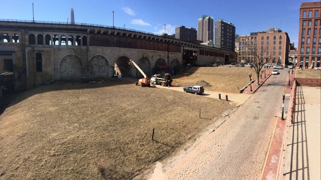
Laclede’s Landing is barely a place anymore, with so many holes in the formerly urban fabric. Between grassy blocks are harsh surface parking lots, it’s clear there needs to be a plan to infill some of these holes with new construction. It make take 20 years to happen, but the planning needs to happen now.
With such a tiny amount of land between the King & Eads bridges I think every bit should get filled in. Knowing that isn’t likely, the land closer to the south should be filled in while land to the north isn’t as critical to completing streetscapes and urban vistas.
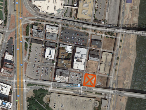
But if Great Rivers Greenway goes ahead with this park next to the Eads Bridge, what should we call it? Eads Transit Park?
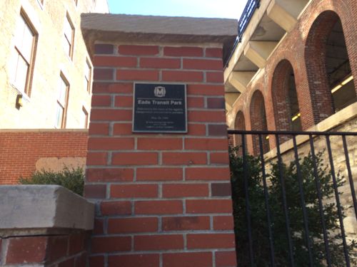
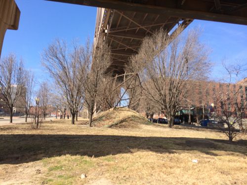
A tiny park next to a massive park that is growing in size by the size of the Arch parking garage and the width of Washington Ave is a huge mistake! This land is an opportunity to add much-needed building mass, people, activity, etc right next to a light rail station. Great Rivers Greenway can’t get into the development business but I’d think they could buy and hold for a developer. If they really have the urge to green up Laclede’s Landing they could unlock Metro’s Eads Transit Park and/or do something with the mess under the King Bridge.
Hopefully Great Rivers Greenway will reconsider, so the land adjacent to the Eads Bridge might someday see new constriction. Maybe a demonstration is needed to convince them?
— Steve Patterson
So, the city should twiddle its thumbs for 20 years hoping something might happen and deny a group that wants to do something positive in the present? Nonsense.
If land values and demand increases that park will be gone.
It’s nonsense to think any park space will ever be sold for private development. Wouldn’t happen, Mayor Slay told me as much years ago when discussing the Gateway Mall.
I’ll repeat, given that the parking garage on the south side of the Eads bridge is slated to be demolished, and that most “trailheads” usually include parking, the smartest thing GRG can do here is to make this a pay parking lot (or parking garage) and use the revenue to support its other programs. Sucks for the Landing and the urban fabric, but it’s the most logical option short of a new mixed-use structure. Leaving it as a free lot would just see it filled with visitors to the Landing and the Arch, NOT actual trail users. (And no, we don’t need another local park next to a transit park next to a national park!)
The museum under the Arch is being expanded, the Arch entrance will face west toward the city. The point is to better connect the Arch with downtown, with visitors arriving by car parking in one of the many downtown garages, using up excess supply.
People are lazy – the closest parking always fills in first, and people from out of town (most visitors to the arch) want to park where they can see where they’re going, not park blocks away and walk through a “scary”, unfamiliar downtown area. Yes, I get the theories and the arguments for removing the existing garage, but for many visitors to the Arch, both downtown and parking garages can be intimidating – not everyone comes from urban areas, so surface parking within sight of the Arch is way more comfortable than a garage.
So because people are scared of walking and not everyone comes from urban areas we should just make everything within sight of the Arch parking to accommodate them. Totally acceptable. Sounds like you may already work for the City, and if not, you may want to apply, you’re just what they’re looking for.
Read what I said – I agree with Steve, the best use would be a new mixed-use structure. But until there’s a market to build one on the site, until GRG decides to sell the site to a developer, GRG owns the site and, I assume, plans to put it to a productive use. They can do what they normally do, build a free parking lot, put in some grass and trees, and create a SUBURBAN-scale trail head. All I’m saying is that there is demand for parking next to the Arch, so it would make more sense for GRG to charge for parking at this location and use the revenue as a new income source in their budget. I also don’t agree with Steve that connecting the Arch with downtown will magically make downtown more attractive to visitors to the Arch.
I see three groups of visitors – locals taking out-of-town visitors, people in town for other reasons deciding to visit and people doing cross-country road trips stopping for a few hours. The first and last groups are like many other downtown visitors – they go down and park, do their one thing, then leave – better connections aren’t going to make much of a difference (better parking will). The middle group is the only group that might be attracted by better pedestrian connections, but only time will tell. Right now, we have Hooters and CityGarden close by, the City Museum, Busch Stadium / BPV and Washington Avenue are all quite a hike, and all the other “sights” are much further away. It’s not much different than the dynamic in Chicago, between the Loop and the museums – yes you “can” walk, but most choose not to.
Important to note too that GRG already has trailhead parking at the Union Light & Power building south of Rootwad Park, and Lumiere “gifted” them the large lot directly across LKS from the President casino.
I think GRG is planning on activating that space. Does anyone know who owns the lot directly east of the Switzer lot? I’d be a bit more comfortable with GRG utilizing that one as it actually fronts the riverfront trail like the old casino lot.
If a Park does go in there, a suggestion for its name would be Priscilla Baltimore Park. Priscilla “Mother” Baltimore, was a slave brought to St. Louis from Kentucky prior to the Civil War. She went on to buy her freedom and is one of the founders of Freedom Village, which was later absorbed into the platted town of Brooklyn, Illinois. She was actively involved with the movement of the AME church westward and was prominent in the development of a number of AME churches and congregations on both sides of the our river here. She would later return to St. Louis where she died (her obituary is documented in the St. Louis Globe Democrat.) The most compelling reason to name a riverfront park after this woman however, is the oral history traditions that Baltimore ferried AME minister William Paul Quinn, a free African American AME preacher who was tried in St. Louis for his preaching to slaves. Priscilla is also said to have ferried slaves to Brooklyn, a refuge for fleeing slaves and to helping them move on to Alton and other Underground Railroad sites. St. Louis has been slow to equally recognize the achievements of its women in the public sphere with parks, memorials, etc. This could be a incredibly fitting memorial rather than naming it after a political crony.
Thanks for sharing…. that could lead to more riverfront trail interpretation with Mary Meachum Freedom Crossing.