14th Street Conflict: Transit vs Events

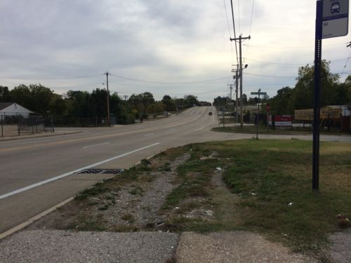
14th Street is a very popular north-south street through downtown St. Louis. Unfortunately, it’s too popular. Nearly every MetroBus that comes into downtown uses 14th just as nearly every event shuts down at least one intersection along 14th, usually at Chestnut, requiring many buses to reroute.

14th Street was closed between Clark & Pine recently for the Taste of St. Louis
From Metro's downtown detail map we can see all the bus routes that pass through the 14th & Chestnut intersection.
From Metro’s downtown detail map we can see the six bus routes that pass through the 14th & Chestnut intersection: 10, 32, 41, 74, 94, 97.  The 4, 11, 30, 58x, 410x use 14th St south of Market
14th Street closed at Pine on a thursday to set up a weekend event
14th Street closed at Pine on a thursday morning to set up for a weekend event

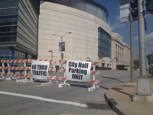
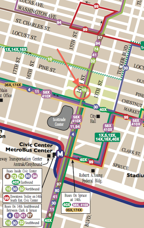
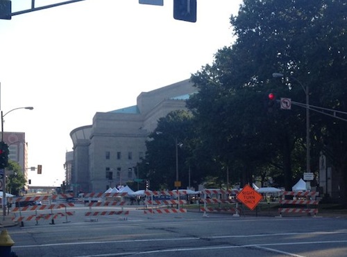
It seems like twice per month there’s a festival, concert, run, walk, bike ride, parade, or something that totally screws up the bus routes and schedules. All because the events shut down the primary route used by the buses. Because we’ve messed up our street grid for years by removing streets and making others one-way 14th St is the only choice for these bus routes. The reroutes that go into place are time consuming, making that route late everywhere it travels.

The solution is to remove the conflict, not close 14th St. How you ask? Not possible right now, but perhaps once the area is redesigned.

The Gateway Mall Master Plan calls the area around Soldiers' Memorial the "Civic Room", click image to see section
The Gateway Mall Master Plan calls the area around Soldier’s Memorial the “Civic Room”, click image to see section. 14th St separates the left third from the right two thirds+.

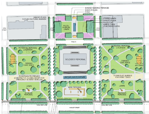
From the Master Plan:

The Civic Room will create a large unified space well-suited for civic events, markets, festivals and concerts. In order to achieve this, it is anticipated that Chestnut Street would be closed incrementally over time, beginning with temporary closures for festivals, and ultimately considered for permanent or seasonal closure. though still allowing emergency and service vehicles access.  Chestnut Street should be still be hard surfaced with a paving different than surrounding areas, to accommodate tents and other services necessary for festivals. Locations for performance stages and cultural or art annexes should be provided to further define the civic character of the space and create attractions to activate the mall.   

This is good, just the wrong location. Rather than Tucker (12th) to 15th I think it needs to be 14th to 17th or 18th. 18th St is a busy street but it doesn’t have any bus routes, close it for an event to combine with Aloe Plaza to 20th. But from 15th to 20th the space is narrow, from Market to Chestnut only.

If the St. Louis Streetcar gets funded and built, 14th St will need to stay open so I hope someone creative can find a way to hold events here while still allowing all transit vehicles continuous access to 14th St.

Transit is important but so are events. One shouldn’t be compromised by the other. Tomorrow’s post will be about design issues with the current area around the Soldier’s Memorial along with some possible solutions.

— Steve Patterson


Poll: Should St. Louis Sign The Water Consulting Contract With Veoila?

Next year St. Louis will turn 250 years old. In those early years St. Louis didn’t have a municipal water system, but for the last 178 years we have.

1764: The City of St. Louis is founded.
1831: The City of St. Louis contracts with Abraham Fox and John Wilson to build a waterworks.
1835: The City of St. Louis buys out the bankrupt Fox and Wilson, becoming sole owner of the St. Louis Waterworks. (St. Louis Water history)

ABOVE: Cover of American City: St. Louis Architecture.  Text by Robert Sharoff & photographs by William Zbaren
Cover of American City: St. Louis Architecture by Robert Sharoff & William Zbaren features a water inlet on the cover

With that long history comes old infrastructure. To get advice St. Louis issued a request for proposals to provide a “Operational Efficiency and Value Creation Analysis”:

PROJECT OBJECTIVE:
The objective of the St. Louis Water Division is to retain a Consultant or Consultants with expertise in water system operations that can provide insight and new ideas, programs and approaches on ways to increase the Water Division’s efficiency and/or revenues in order to postpone or lessen future water rate increases and to improve customer satisfaction. The Cityand the Water Division for the most part would like to identify the ideas, have them bedeveloped into projects or programs and be implemented through Performance Contracting such that the City has no additional initial outlay of funds for capital projects or procurement of equipment or services. There will be some Non-Performance Contracting efforts that will result in delivery of a report with recommendations and a detailed implementation plan that can be executed by the SLWD or others

Sounds like a proactive step, but the winner of the bidding process, French firm Veolia, is viewed by some as a company that specializes in the privatization of public water systems. So the fear is a short-term consulting contract is the gateway to handing over a valuable city asset.

Mayor Slay is saying Comptroller Green has a duty to sign the $250,000 contract since it went through the bidding process. Meanwhile, Lewis Reed, President of the Board of Aldermen, is calling for hearings over the handling of the contract.

For months a grass-roots organization Dump Veolia has fought the contract at every step:

We are a group of concerned residents who want St. Louis to reject a proposed water consultancy contract with the French multinational corporation Veolia, the largest water privatization company in the world.? Learn what the campaign is about, who is mobilizing against Veolia, and why.???

The poll question this week is “Should St. Louis Sign The Water Consulting Contract With Veoila?” The poll is in the right sidebar, results to be posted on Wednesday October 20th.

— Steve Patterson


Large 19th Century Home Being Razed, 19th Ward Not In Preservation Review

The once-stately residence at 3630 Page Boulevard was used as an assisted living facility for years. Now the 1888 structure is being razed.

2009 photo of Page Manor from GEO St. Louis
2009 photo of ‘Page Manor’ from GEO St. Louis
Earlier this week
Earlier this week from the #94 MetroBus

The sad part is this property is in the 19th ward, so Cultural Resources wasn’t even given a chance to review the request for the demolition permit. Most of the city is in a “preservation review” area where trained staff look at requests for demolition, referring some to the Preservation Board for a decision on the fate.

Note: city records list the property address as 3630 Page Blvd, but Page Manor used the address 3636 Page Blvd.

— Steve Patterson


New Wellston Child Care Center Under Construction, Adjacent To MetroLink Station

Construction workers are busy building a new child care center near the Wellston MetroLink station:

The Wellston Developmental Child Care Center is a key component of the Wellston Sustainable Neighborhood Initiative Masterplan. Located adjacent to a Metrolink Light Rail Sytstem (with which it will share parking) as well as being in close proximity to the Metropolitan Enterprise Center (a new job training center) will allow the Development Center to attain the goals of providing early childhood education in a depressed neighborhood, preparing children for the K-12 system, and providing day care assistance for parents training for new jobs.

The 14,650 SF building is oriented primarily on an E-W axis maximizing orientation for energy efficiency and daylighting. The building footprint had been placed on the site to minimize driveway length and take advantage of the adjacent public parking. Stormwater from the site will be handled by a series of micro-detention areas integrated with native landscaping. The program includes public, administrative, infant/toddler, classrooms and support spaces. (Hellmuth + Bicknese Architects)

I’ve requested the site plan & Wellston masterplan from the architects & county economic council, neither have been received.

Construction of the building in Powell Park, seen from the far end of the station's park-n-ride lot
Construction of the building in Powell Park, seen from the far end of the station’s park-n-ride lot
ABOVE: Over the last 19 years residents have worn a clear path across the open field...ur, park
Last year Powell Park was just a field that area residents cut through to reach the bus & train. Click image for post.
The long used shortcut is now blocked
From the parking lot we see the point where the shortcut comes through the greenery

The shortcut was the most direct path for pedestrians to reach public transit.  It wasn’t even paved, but since 1993 it was heavily used. However, I support building on the field — especially facilities that’ll benefit the community.

How will pedestrians now reach the station?

Rather than cut through the field to the right, pedestrians must now walk along Werley Ave
Just past the construction fence is the west edge of the large station parking lot.
Turning east we see the parking lot, the station is at the bottom of the hill. The stop for the #94 MetroBus is on the left

The new child care center will use the existing parking, rather than have a separate parking lot. Still, the parking lot remains a divider between train, bus, residents, and new child care center. It’s possible pedestrian routes will be constructed in the parking lot to connect these elements. Without pedestrian connections the new construction is just transit-ajacent, not transit-oriented.

Once I see an actual site plan I’ll post an update.

— Steve Patterson


Pedestrian Access To Metro’s Rock Road MetroLink Station/MetroBus Center Is Awful

The Rock Road MetroLink station was designed in the early 1990s as a drive-to station with 183 parking spaces. For twenty years now pedestrians have endured horrible conditions to reach the train platforms and MetroBus lines. 

On Sunday I joined a Citizens for Modern Transit (CMT) Ten Toes walking group as it did a walk audit in the neighborhood to the south.

We started at the ticket machines, our first stop was the entry. Half did a straight shot through the parking lot, the rest of us went the long way on the sidewalk. Photo: CMT
We started at the ticket machines, our first stop was the entry point. Half did a straight shot through the parking lot, the rest of us went the long way on the sidewalk. Photo: CMT
ABOVE: Parking is placed between the entry off St. Charles Rock Rd. and the station itself, pedestrians must either go out of their way to stay on the sidewalk or schlep through the parking lot
In April 2012 I noted: The parking was placed between the entry off St. Charles Rock Rd. and the station itself, pedestrians must either go out of their way to stay on the sidewalk or schlep through the parking lot. Click image to view April 2012 post on the Wellston & Rock Road stations
ABOVE: Approaching from the west pedestrians have worn a strong path to reach the station
Approaching from the west pedestrians have worn a strong path to reach the station. April 2012
We went south on Kingsland Pl to Page, most of the way we had to use the road since no sidewalks exist.
We went south on Kingsland to Page, most of the way we had to use the road since no sidewalks exist.  Photo CMT
At Page we headed west to Ferguson
At Page we headed west to Ferguson, click image for map
At Ferguson I had to split off since I forgot to charge my chair the night before. I caught a #94 back downtown.
At Ferguson I had to split off since I forgot to charge my chair the night before. I caught a #94 back downtown. Click image for map.
Ferguson surprised me with cute houses and a decent, but narrow, sidewalk. The only issue is many people park on the curb.
Ferguson surprised me with cute houses and a decent, but narrow, sidewalk. The only issue is many people park on the curb. St. Charles Rock Road can be seen at the end of Ferguson
When you reach St. Charles Rock Road there's no easy or safe way to cross to the north side.
When you reach St. Charles Rock Road there’s no easy or safe way to cross to the north side. So I decided to stay on the south side and cross at the entry to the station. Click image for map.
I was in the upper left and had to get to the lower right to cross the street and enter the station property.
My destination is marked by the red arrow, but traveling the short distance looks problematic
20 years of pedestrians have worn a path
I had to use the shoulder because my chair can't jump curbs
I had to use the shoulder because my chair can’t jump curbs, a worn path is visible.

Again, it baffles me that we could spend hundreds of millions to build transit infrastructure and, after two decades, not do what it takes to make it accessible nearby to pedestrians. No wonder we’ve not seen any new development around this busy station.

— Steve Patterson


Advertisement


[custom-facebook-feed]

Archives

Categories

Advertisement


Subscribe