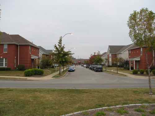
When cold water flats and tenements were cleared just north of downtown for St. Louis’ first high-rise public housing project, Cochran Gardens, several blocks of 8th Street were erased from the grid. Six decades later 8th Street was rebuilt* when the mixed-income Cambridge Heights apartments & townhouses replaced Cochran Gardens’ towers.
* 110 feet of 8th Street wasn’t replaced!
This short missing piece is a connectivity problem for those of us who live here. Later, when Cass Ave over I-44 (aka I-70) was raised as part of the Stan Musial Veterans Memorial Bridge project 7th Street got disconnected from Cass Ave. So now neither 7th or 8th connect to Cass. Getting to/from the bus at Cass Ave & Broadway is likely the primary reason for needing access here, it would also be nice when we go to Shady Jack’s or walk/roll up Broadway.
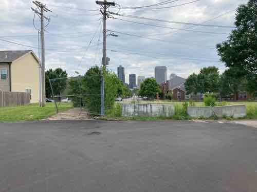
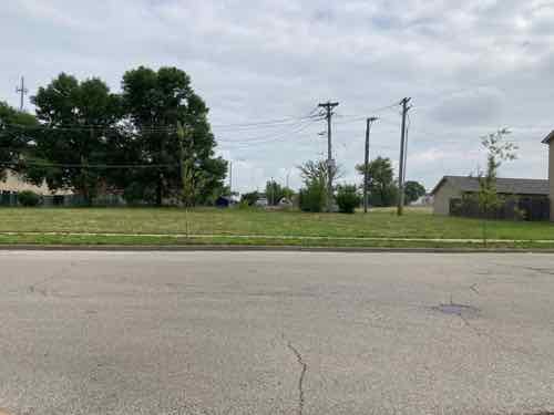
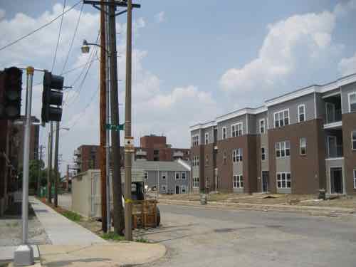
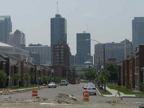
A little bit of the original 8th Street exists south of Cass Ave, but it quickly ends at an alley. Jersey barriers exist to keep drivers from going straight ahead.From the broken sidewalk on the east side of 8th you can see a clear route to 8th Street 100 feet further south. The west side of 8th, unfortunately, has no sidewalk.In the field you can see beyond Dickson Street to 8th StreetAt the public sidewalk you can look south along 8th Street to downtown. 8th Street is the center of Cambridge Heights.
Motorists use the alley south of Cass to get to/from Cass Ave, but pedestrians often walk though vacant land where 110 feet of 8th street should be. As you’ll see, putting in street, curbs, drainage, etc would be challenging & costly — all that’s needed is a 110 foot long sidewalk and a couple of curb ramps.
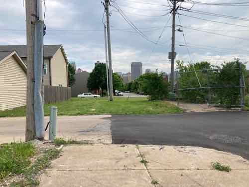
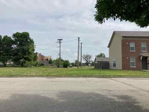
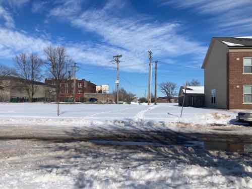
Looking toward Cass Ave from the SW corner of 8th & Dickson streets.Looking toward Cass Ave from the SW corner of 8th & Dickson streets.The same view after a recent snowfall. Two desire lines where people walked are clear. A community center is visible on the left, but no good way to get there directly.
This is needed because going between the neighborhood and Cass Ave is challenging as a pedestrian. I’ve thought so for the 3+ years I’ve lived here. I’ve also seen a woman at least 15 years my senior (so 70+) walking though the grass with a cane. The trail through the snow earlier this year was also a clue.
You might be thinking this land is vacant do it can be developed for more housing. Let’s take a look at the property lines.
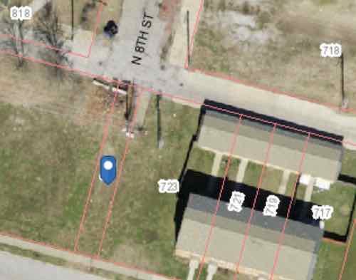
The blue dot marks a 15 foot wide parcel owned by the St. Louis Housing Authority (725 Dickson Street). They also own the land from here to 9th Street. 723 Dickson Street is 64.26 feet wide, includes the 22 foot wide end of 3 townhouses.
My assumption is the 15 foot wide parcel known as 725 Dickson (map) is there to prevent anyone building over utilities, like sewer, under the old 8th Street. The end row house has a lot of extra land beyond their fence. Basically there’s more than enough width to create a generous pedestrian path. There are some obstacles near the alley.
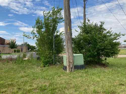
From the alley you can see a little bit of concrete and some useless chain link. And an electric utility pole.From the lot you can see the pole and an electrical box (transformer?). There are also wires to help keep the pole upright on the private land side.
There’s room to fit a 5′ wide walkway at the alley to then toward 8th & Dickson streets, we just need to figure out property lines, utilities, easements, etc. City mowers have a hard time during the summer keeping the back area cut — a private home owner would get a violation letter from the city for such conditions. The elevation is slightly higher at the alley than south at Dickson Street.
The need exists, much of the land is owned by the housing authority. Cost wouldn’t be that substantial. I’d love to see fruit trees planed on both sides of a walkway so the public can access free fruit.
Today’s post is about HOPE VI projects. You may have heard that term before, but if you’re unfamiliar here’s an introduction:
HOPE VI is a program of the United States Department of Housing and Urban Development. It is intended to revitalize the worst public housing projects in the United States into mixed-income developments. Its philosophy is largely based on New Urbanism and the concept of defensible space.
The program began in 1992, with formal recognition by law in 1998. As of 2005, the program had distributed $5.8 billion through 446 federal block grants to cities for the developments, with the highest individual grant being $67.7 million, awarded to Arverne/Edgemere Houses in New York City.
HOPE VI has included a variety of grant programs including: Revitalization, Demolition, Main Street, and Planning grant programs. As of June 1, 2010 there have been 254 HOPE VI Revitalization grants awarded to 132 housing authorities since 1993 – totaling more than $6.1 billion. (Wikipedia)
The short answer is HOPE VI was the program used to raze & replace distressed high-rise public housing with low-rise mixed-income private housing. With the notable exception of Pruitt-Igoe, all of St. Louis’ high-rise public housing was replaced with low-rise housing — three using the HOPE VI program. Pruitt-Igoe was famously imploded two decades before the start of the HOPE VI program.
From a May 2004 research report after a decade of HOPE VI:
Launched in 1992, the $5 billion HOPE VI program represents a dramatic turnaround in public housing policy and one of the most ambitious urban redevelopment efforts in the nation’s history. It replaces severely distressed public housing projects, occupied exclusively by poor families, with redesigned mixed-income housing and provides housing vouchers to enable some of the original residents to rent apartments in the private market. And it has helped transform the Department of Housing and Urban Development’s (HUD) approach to housing assistance for the poor. Thisreport provides a comprehensive summary of existing research on the HOPE VI program. Its central purpose is to help inform the ongoing debate about the program’s achievements and impacts, and to highlight the lessons it offers for continuing reforms in public housing policy.
HOPE VI grew out of the work of the National Commission on Severely Distressed Public Housing, which was established by Congress in 1989. Congress charged the Commission with identifying “severely distressed” public housing developments, assessing strategies to improve conditions at these developments, and preparing a national action plan for dealing with the problem. Based on its investigation, the Commission concluded that roughly 86,000 of the 1.3 million public housing units nationwide qualified as severely distressed and that a new and comprehensive approach would be required to address the range of problems existing at these developments.
In response to these findings, Congress enacted the HOPE VI program, which combined grants for physical revitalization with funding for management improvements and supportive services to promote resident self-sufficiency. Initially, housing authorities were allowed to propose plans covering up to 500 units with grant awards of up to $50 million. (Introduction to an Urban Institute report)
I should clarify the HOPE VI program isn’t limited to only remaking high-rise public housing, but that is the type of distressed public housing we had in St. Louis. Other cities, like Chicago, also used it to replace high-rise projects. Cabrini-Green, for example.
Let’s take a look at the four St. Louis high-rise public housing projects that were replaced with low-rise housing built on a more traditional street grid.
Darst-Webbe
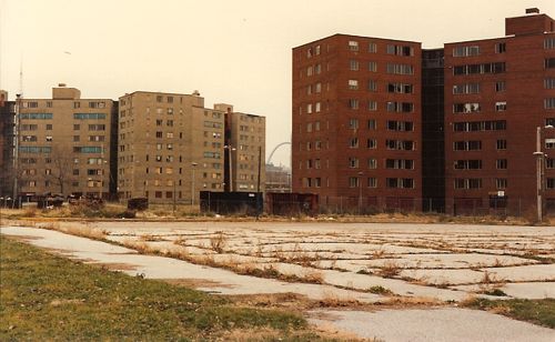
The Darst-Webbe towers on the near south side circa 1990-91, razed
This was officially known as the J.M. Darst Apartments and the A.M. Webbe Apartments. The Darst apts., opened in October 1956, occupied 14.75 acres bounded by Lafayette, Hickory, Tucker (12th) & 14th. The four 9-story buildings contained 645 units. The Webbe apts. opened in May 1961 between the Darst apts. and Chouteau. It had a mix of buildings on 12.27 acres: two 9-story, one 12-story, and one 8-story. These four buildings had 580 units. The combined Darst-Webbe then had 1225 apartment units on 27.02 acres.
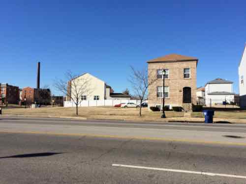
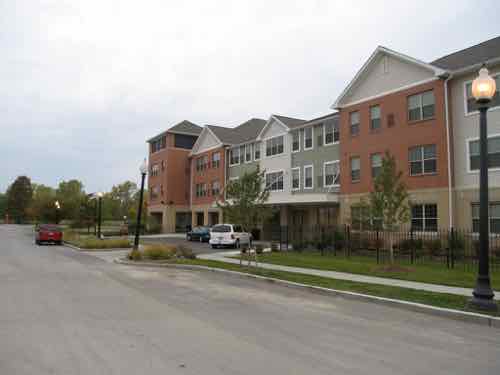
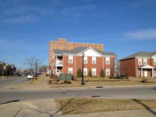
This was the first high-rise public housing project in St. Louis to be razed and rebuilt under the HOPE VI program. In its place is a mix of apartments and privately-owned single-family homes. On the south is King Louie Square apartments, with 152 1-4 bedroom units. In the middle of the redevelopment site is the single-family homes, called La Saison. Habitat for Humanity is building new homes here on the few vacant lots remaining. The north part of the original site contains more apartments, called Les Chateaux — with 40 1-2 bedroom units.
House at La Saison on Tucker near Park Ave, the north edge of King Louie Square can be seen on the left. Photo December 27, 2013.Looking north on 14th street toward LaSalle. The buildings on the left are rental townhouses in the redevelopment area, just not sure if they have a name. Photo: November 7, 2018.
In 1995 HUD gave the St. Louis Housing Authority a grant of $46.7 million to redevelop Darst-Webbe. Defunct developer Pyramid Construction is responsible for the pretentious names.
Vaughn
This was two projects, both called G.L. Vaughn Apartments. The first, opened in June 1957, was bounded by Cass, O’Fallon, 18th, and 20th. It had four 9-story towers on 16.67 acres — with 647 units. The second opened at the NE corner of 20th & O’Fallon in September 1963. Basically this was just an expansion of the project that opened six years earlier, it had one 8-story building on 2.05 acres, 112 units.
The last Vaughn tower being razed in October 2006.New housing, called Murphy Park, had already been built where the other four towers had been razed.The Murphy Park senior building and management offices.Looking south on Vinson Street from a new park on Biddle Street.
Vaughn was completed, to the best of my knowledge without the use of a HUD HOPE VI grant, but like others it got state low income tax credits.
The partnership event highlighted Phase III of Murphy Park. Its 126 units will bring to 413 the total number of rental dwellings built in the neighborhood that once was the site of the notorious George L. Vaughn public housing high-rises. One third of the completed project will be market rate apartments, with the balance constructed as tax credit units – with just more than half available for public housing-eligible families as part of the replacement of the former public housing complex. Units range from two to six bedrooms and include disability-accessible garden apartments. Each apartment features full size appliances including washer and dryer, refrigerator, stove and dishwasher. McCormack Baron Management Services, the management agent, reports that Phases I and II (completed in 1997 and 2000) have high-90 percent occupancy. Phase III units will be available in March 2003. (HUD)
As the above indicates, this was a McCormack Baron development.
Blumeyer
This was officially the A.A. Blumeyer Apartments. It opened in October 1968, bounded by Compton, Delmar, Grand & Page. It had two 14-story buildings for “elderly”, three 15-story buildings, and forty-two 2-story buildings. There was a total of 1,152 units on 33.90 acres.
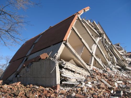
Low-rise & high-rise buildings at Blumeyer before being razed. Photo October 2006Blumeyer Elderly Apartments on Page, January 2007
This was replaced by the Renaissance Place at Grand apartments and the offices of the St. Louis Housing Authority. To the north, across Dr. Martin Luther King Blvd, Senior Living at Renaissance Place was built on land not part of Blumeyer. Additionally, the North Sarah Apartments were built on…North Sarah… to provide additional units.
New apartment within a grid of new streets in February 2013, the last Blumeyer tower in the background — demolition on it began in the fall of 2014
The $35 million dollar HUD grant was issued in 2001. Like Vaughn, this was a McCormack Baron project.
Cochran
Officially the J.J. Cochran Garden Apartments. Completed in April 1953, it was St. Louis’ first high-rise public housing project — more than two years before Pruitt Homes and three years before Igoe Apartments. The 18.03 acre site contained four 12-story, two 7-story, and six 6-story towers — containing 703 units. It was built to clear out old tenemts businesses on the north edge of the business district didn’t like. Then Cochran became a problem, but tenants pushed for the ability to self manage — and won!
Cochran Gardens was a public housing complex on the near north side of downtown St. Louis, Missouri. Construction was completed in 1953. The complex was occupied until 2006, it was famous for its residents’ innovative form of tenant-led management. In 1976, Cochran Gardens became one of the first U.S. housing projects to have tenant management. Built by the same firm, Leinweber, Yamasaki & Hellmuth, as the infamous Pruitt–Igoe complex, Cochran Gardens was more successful than its ill-fated sister project. In the mid 1970s, Bertha Gilkey and a group of friends successfully led a community driven rehabilitation effort; in 1976 she won a property management contract from the city. Independent management improved Cochran Gardens and created small business jobs in the neighborhood. President George H. W. Bush visited the site in 1991, commending tenant management and Bertha Gilkey. However, in 1998 city authorities took over Cochran Gardens, citing tax mismanagement by the tenant association. The buildings rapidly deteriorated, by 1999 vacancy rate increased from under 10% to one-third. (Wikipedia)
I photographed the area in May 2007 as towers still existed and as new construction was going up, streets going in.
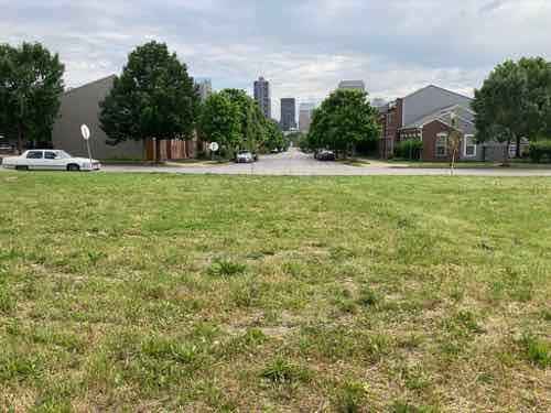
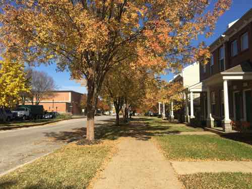
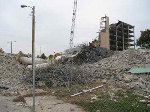
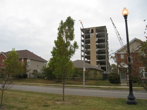
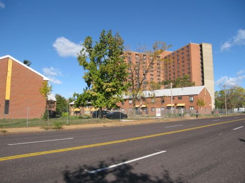
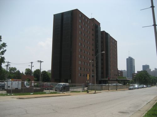
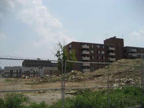
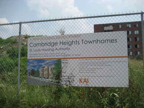
The last high-rise tower from the Cochran Gardens project was razed in 2011. This is 9th & O’Fallon on May 29, 2007.At 7th & O’Fallon you can just see the historic Neighborhood Gardens project on the left, new Cambridge Heights apartments on the right. In the background is an old Cochran tower about to be demolished. Note traffic signals were still in place along 7th street.From 9th street we can see the other side of the Cochran tower before demolition, and new townhouses facing 8th street. The building on the horizon is on 7th, was part of McGuire Moving & Storage.Project signLooking to the left we see more new townhouses between 8th & 9thLooking south on 8th Street from Dickson Street. Dickson Street didn’t exist between 7th and 9th prior to Cochran, but the street name was used east of 7th. Eighth street was removed for Cochran, it was mostly rebuilt.
This project was completed by an LLC that includes architect Michael Kennedy of KAI (previously known as Kennedy Associates, Inc). McCormack Baron was management from the very beginning, until February of this year. In a future post I’ll go into more detail on Cochran Gardens & Cambridge Heights.
Summary
These four areas are all significantly better because of each redevelopment. The New Urbanist influence has been a key factor in their success. The buildings in all four orient toward the public street. HOPE VI projects have valid criticism, largely the reduction in the number of public housing units for the very low income. The other is the charge of gentrification, a valid claim in other cities but not in St. Louis. More on that in the future.
Bocce is one of many long-standing traditions on The Hill
When you think of an Italian neighborhood in St. Louis, The Hill naturally comes to mind.
The Hill’s roots are interspersed with the history of St. Louis, generating two of the region’s proudest exports – world-class athletes and Italian cuisine. Baseball’s Yogi Berra and Joe Garagiola grew up here, and today it maintains a traditional collection of authentic Italian bakeries, grocery stores, restaurants and mom-and-pop trattorias.
Everything is colorful here – even the fire hydrants are painted red, white and green. Twenty-first century additions include coffee houses, studios, retail and small businesses that create additional energy in the cozy enclave. Its epicenter is one intersection that sums it up perfectly, with St. Ambrose Catholic Church on one corner, an Italian bakery/restaurant on another, an import shop across the street, and a neighborhood tavern/bocce garden on the fourth corner. (Explore St. Louis)
In the late 19th & early 20th century immigrants from Sicily first settled in the ethnically diverse neighborhood on the North edge of the Central Business District and further North — the southern part of today’s Columbus Square neighborhood.
The Italians came to St. Louis in the late 1880s. They lived in what is now downtown St. Louis among the Germans, Greeks, and Irish and attended St. Patrick’s Catholic Church or Our Lady Help of Christians in an area referred to as Little Italy, along Cole Street.
In the early 1900s, the Italians started another community southwest of Little Italy called The Hill. By the mid-1900s, most Italians had left Little Italy and moved to The Hill. (St. Louis Genealogical Society)
By the time they arrived the shopfronts, flats, and tenements were already old. In addition to the races mentioned above, Jewish families also called the neighborhood home.
Before going further it’s important to note that today’s boundary lines didn’t exist. Highways didn’t cut through neighborhoods, wide streets like Cole were the same width as Carr. Cole wasn’t even called Cole.
Here’s a look at East-West street names and what they were called in 1909, starting at Washington Ave and going North to Cass:
Washington Ave was Washington Ave
Lucas Ave was Lucas Ave
Convention Plaza was Delmar, called Morgan in 1909. (Could’ve been the Morgan divide?)
Dr. Martin Luther King was Franklin
Cole was Wash
Carr was Carr
Biddle was Biddle
O’Fallon was O’Fallon.
Cass was Cass
Again, Cole today is a very wide street that separates Downtown from Columbus Square. Like Franklin to the South, and Carr to the North, it was a normal neighborhood street — not a dividing line.
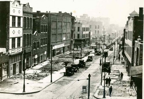
Franklin Ave looking East from 9th, 1928. Collection of the Landmarks Association of St Louis
Major change came as the city decided to widen comfortable neighborhood streets like Franklin. Everything in the photo above has been part of the convention center since the mid-1970s. One neighborhood spaghetti joint became St. Louis’ top restaurant — Tony’s:
Before Tony’s, the Bommarito family had St. Louis’ first Italian bakery. It was at 7th and Carr Streets, plus they operated a spaghetti factory at 10th and Carr. Tony’s was created by Anthony Bommarito in 1946, and, in its earliest life was a small café, soon to be called Tony’s Spaghetti House and by the early 1950s Tony’s Steak House. It was located just north of the heart of downtown at 826 N. Broadway between Delmar Boulevard (formerly Morgan St.) and Franklin Avenue in the old Produce Row district at the edge of the soon to disappear Little Italy neighborhood. Family names of those who lived nearby included: Polizzi, Impostato, Olivastro, Lapinta, Viviano, Difirore, Impielizzeri, Tocco, Arrigo, Marino and Capone. (Tony’s)
In the early 1990s Tony’s was forced to relocate because of the construction of the football stadium being built to get an NFL expansion team. Ton’y was on the East side of Broadway, part of today’s Baer Plaza. As indicated above, Broadway was also part of Produce Row, before moving to 2nd & North Market in the 1950s. [Produce Row history]
At least one Italian immigrant from the neighborhood likely worked at Produce Row: Frank Cammarata.
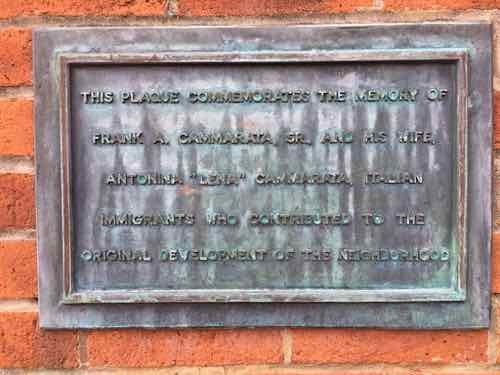
Small plaza on the SW corner of 11th & Carr was built in 1981 as part of the Columbus Square apartments, now known as CitySide.A small plaque on the South wall reads: “THIS PLAQUE COMMEMORATES THE MEMORY OF FRANK A. CAMMARATA, SR., AND HIS WIFE, ANTONIA “LENA” CAMMARATA, ITALIAN IMMIGRANTS WHO CONTRIBUTED TO THE ORIGINAL DEVELOPMENT OF THE NEIGHBORHOOD.
This little plaque is why I began looking into Italian immigrants into the neighborhood. Here’s what I’ve learned through a lot of digging:
Frank Cammarata’s middle name was William. He was born in Italy and came to the states on August 28 1913, via Canada. A Joseph Cammarata was already in St. Louis, presumably his brother, with various addresses over the years: 614 Biddle, 616 Biddle, 618 Biddle, 1003 N 6th, and 1121 N 11th. In 1915 Frank Cammarata was living at 805A Carr.
Directories & census listed Frank as a fruit pedlar, though he was no longer working by the 1940 census. Lena Cammarata died in late August 1939, they were living at in the Shaw Neighborhood at 4152 Castleman. Frank Cammarata died in 1950 at age 72, still living in Shaw on DeTonty.
The Cammarata’s were already living on Castleman in 1929. I contacted the apartment complex owner, the Mills Group, online to see if they knew anything. They never responded. I stopped by the apartment leasing office to ask. Due to many steps I couldn’t enter, so I called and two women came out to chat. They didn’t even know a plaque existed. They suggested I ask the city, though the plaque is on their private property.
One of the Cammarata’s sons was Frank A. Cammarata, Jr. (1912-1986). My assumption is the 1981 plaque got put up because of him, but the maker goofed and put the son’s middle initial “A” instead of the father’s “W”. I’ve been unable to find anything to substantiate how they contributed to the “original development of the neighborhood” — especially since the neighborhood was already old when they were born in Italy.
As one of the oldest neighborhoods, the building stock was old. Many of the 1909 Sanborn Fire Insurance map pages indicate the neighborhood buildings are old, many are tenements. In 1937 a private housing project, Neighborhood Gardens, was built on a single block. It had goal of providing affordable housing to low-income neighborhood residents. It failed, as the rents needed to be higher than anticipated to cover obligations.
When the federal government got into the low-income housing business the neighborhood was the site of one of the city’s first high-rise public housing projects: Cochran Gardens. It opened in 1953, a year before Pruitt-Igoe located, due west. This brings me to the story of two of the last old Italian-American businesses in the neighborhood.
From the Post-Dispatch November 9, 1936 page 33 of 36 [a daily special section)
For the last 31 years the Rosciglione family has been, by popular appointment, official confectioners to the Italian-American population of St. Louis. For 31 years the Roscigliones, brothers and father, have been shaping almond paste fruits and flowers, molding hard sugar scenic pieces and baking rich cakes for a critical clientele. No wedding, birthday, feast day, church or State holiday has been properly observed in Italian-American homes without some sweet, traditionally symbolic of the day, from the Rosciglione kitchens at 1011 1/2 North Seventh Street.
This would’ve been on the west side of 7th Street between Wash (now Cole) and Carr. Later in the same article:
When Frank Rosciglione came to this country in 1906 from Palermo, one brother, Tony, already in St. Louis and had a small confectionary shop on Eighth street. Business was good, so he sent for his brother, this time Frank. Shortly afterwards, the two moved their pastry tubes, baking pans and molds over to the Seventh street location. The next year business had increased again so they sent for another brother, Dominick. When they thought they were pretty well on their feet, in 1911, they sent for their mother and father who still kept the confectioners shop in the Old Country. Now all are gone except Dominick who carries on the family profession with one helper and his oldest son.
More than 15 years after Cochran Gardens opened, the neighborhood had changed. The shiny new housing project was losing its luster. Rent strikes were happening at Cochran, Pruitt-Igoe, and other housing projects.
The Post-Dispatch on July 20, 1969 page 119 of 338 had a story about the last two Italian-American businesses leaving the neighborhood, not for The Hill, but St. Louis County.
“We cannot endanger our customers,” said tall, sandy-haired Peter Rosciglione, 47 years old. He was explaining why he was closing his 70-year-old bakery at 1011 North Seventh Street. He and his wife, Josephine, and their son, Peter, have packed up the bride-and-groom figures for the tops of wedding cakes, the ornate, old-fashioned candy jars, the molds for three-foot sugar dolls. All these things will be carefully placed in their new store in St. Louis County, at 9839 West Florissant Avenue, Dellwood.
Rosciglione related that in the last month, six customers were approached by innocent-looking small boys who asked for the time, snatched the exposed watches and ran. His shop and the Seventh Street Market, a meat market at 933 North Seventh Street, have been robbed “over and over again” after hours, though the shopkeepers have not been held up.
“I work with this on the counter,” he said, holding up a pistol. “We have to walk with our women customers to their cars to keep them from having their purses snatched. Recently I heard that because we were spoiling the purse-snatching business for the juvenile gang, that they were out to get me.”
“This is just one mass jungle,” Rosciglione said. “The good families who live nearby in the Cochran housing project and in the neighborhood are as terrified of the gangs as our customers are. I can’t allow them to jeopardize themselves for our merchandise any more.
Rosciglione Bakery still exists today…in St. Charles, MO.
Vincenzo Rosciglione came to the United States in 1898 from Palermo, Sicily. He opened the first Italian Bakery in downtown St. Louis at 1011 North 7th Street. The bakery was well received by the large Italian community in the downtown area known as “Little Italy“.
Vincenzo’s son, Francesco, still in Sicily studying under a famous pastry and sugar artist, was sent for at the age of 16. He and his wife, Cosimina, ran the well established bakery until his death in 1949. After working under the tutelage of his father for many years, Peter and his wife, Rose, took over the bakery.
The bakery left downtown St. Louis in 1969 and opened in Dellwood, Mo. where it remained until 1997. Rosciglione Bakery then moved to it’s present location in St. Charles, Mo. where it continues to be family owned and operated by 4th generation, Francesco Peter Rosciglione. (Rosciglione Bakery)
The Bommaritos and Roscigliones both lay claim to being the first Italian bakery, not sure which, if either, is correct. The Dellwood address where Rosciglione Bakery moved to in 1969 is the original Sweetie Pie’s location.
I still feel like I have so much to learn about the former residents of what’s now known as Columbus Square neighborhood. Hopefully some of you will know bits & pieces that’ll help with the puzzle.
AARP Livibility Index
The Livability Index scores neighborhoods and communities across the U.S. for the services and amenities that impact your life the most
Built St. Louis
historic architecture of St. Louis, Missouri – mourning the losses, celebrating the survivors.
Geo St. Louis
a guide to geospatial data about the City of St. Louis