October 31, 2022Featured, Site Info, Steve PattersonComments Off on 18th Anniversary of UrbanReviewSTL, Stage 4 Kidney Cancer Still “Stable”, Gathering Today Noon-2pm
Eighteen years ago today I registered the domain UrbanReviewSTL.com and began blogging about urban planning in St. Louis. YouTube didn’t exist yet. Facebook was known as The Facebook, still limited to college students at many universities. My husband (m 2014) was barely a year out of high school. Some of you were still in school. I started this blog as a way to clear my head as my father recovered from a heart attack at the start of the month.
It worked, allowing me to focus my thoughts. Still does.
Now, nearly two decades later, I have more ideas than energy to research, photograph, write, and publish them. Three years ago I disclosed I have cancer, I found out a couple of weeks later it was stage 4 kidney (renal cell carcinoma). I didn’t know what to expect in terms of life expectancy. I’m very happy to still be alive, and doing well considering.
By well I mean handling the side effects okay. My days are now spent preparing & eating 7 small meals per day, plus 7 glasses of water — 1.5 liters each day. I take medications 4x per day, 5 on Mondays. I get an infusion of Nivolumab (Opdivo in commercials) every four weeks. The cancer medication I take each night, Cabozantinib, costs $22k per month. My Medicare plan covers most, a Siteman Cancer Center social worker gets grants to cover the $1,100 per month co-pay. Numerous foundations exist solely to help cancer patients with medication co-pays.
I’m not complaining, I have it significantly better than many cancer patients. I’m sharing to explain why I haven’t blogged as much as I used to. But I have reprioritized my life to rest, work on my affairs & bucket list. I know my pricey treatment will eventually stop working, but I don’t know when. There are additional treatments to try at that point.
I hope to be around to celebrate this blog’s 20th anniversary in two years. The 25th anniversary in 2029 would be awesome, but not as likely.
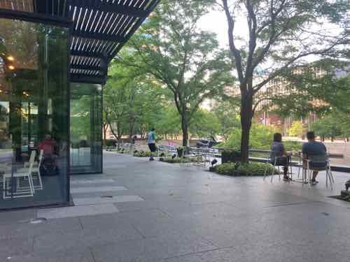
Kaldi’s patio in Citygarden.
As previously announced I’m going to be available for outdoor gatherings. This afternoon I’ll be at Kaldi’s Coffee at Citygarden, 808 Chestnut, noon-2pm. If you don’t see me outside I may have had to go in to the restroom. Please stop by to chat.
More will happen, weather permitting. I hope to find more outdoor locations near a restroom. I considered Forest Park, but the elevator at the Forest Park-DeBaliviere station is still out of service after historic flooding in July. Location suggestions welcomed.
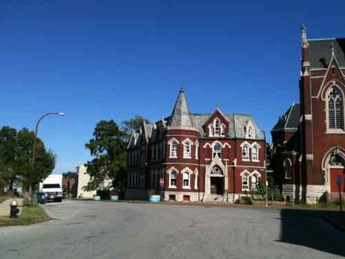
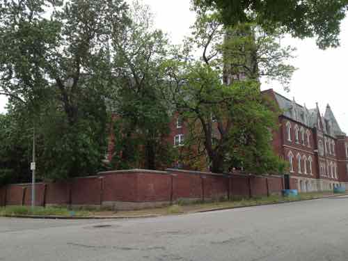
A major reason why I decided to make St. Louis my home back in August 1990 was the complex street grid and the buildings that neatly fit into it. One of the finest examples of fitting into our decidedly non-orthogonal street grid is the former St. Liborius Church complex, bounded by Hogan, North Market & 18th streets. This is where two different grids collided (View in Google Maps). When two grids of different orientations met the result was often awkward — this created very interesting buildings on non-rectangular sites. The views looking down streets as they bend into another grid alignment can be spectacular.
Looking east on North Market in September 2011. The former convent is in the center, the church on the right.
St. Liborius was a catholic parish founded by German immigrants on October 21, 1856 – 166 years ago today. In the 1850 census St. Louis had a population of 77,860 — that was a 372.8% increase over the 1840 census. By 1880 the population was 350,5218.
In March 1888 work on the foundation was underway, their existing church & school were a few blocks to the west. In June of that year it was reported the cost was $100,000 and “much of it was on hand.” In 2022 money that’s like $3.124 million!
“The church was completed in 1889. The rectory was built the following year and the convent was built in 1905. The School Sisters of Notre Dame taught in the parish school from 1859 to 1969. The parish buildings were declared a City Landmark in 1975 and listed on the National Register of Historic Places in 1979.” (Wikipedia)
The year after the church opened the 1890 census showed the St. Louis population had grown to 451,770.
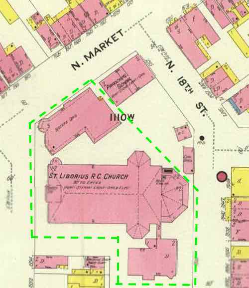
Let’s take a look at the church and surroundings in 1909.
The October 1909 Sanborn Fire Insurance Map shows the church, convent, and rectory –plus a school & other structures on the site. Only the 3 circled in green remain, everything else in this view is gone. Click image to view full page of the 1909 map. Pink is masonry, yellow is wood frame.
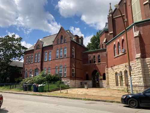
The 1910 population was 687,029. By this point the parish was more than half a century old, the sanctuary more than two decades. In late August I finally got up close to the buildings, and saw inside the sanctuary.
Getting closer we can see the front relationship between the convent and church
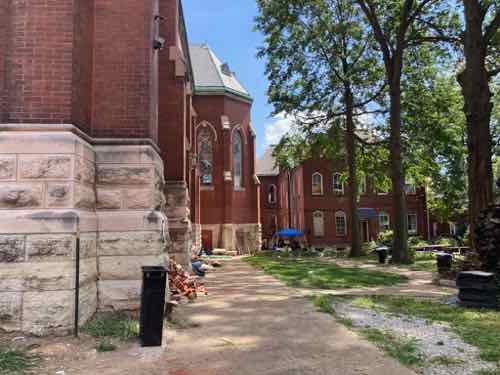
Around the north we see a brick wall where the school had been.
Inside the wall we see the large space between the sanctuary and convent.
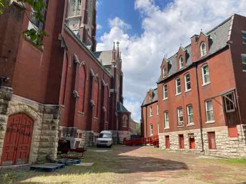
The rectory faces 18th Street. With the grade change the 2nd floor of the rectory connects to the main floor of the back of the sanctuary. Great use of topography.
Back around near the front corner of the church we see the back of the rectory. Additional buildings were to the right in 1909.
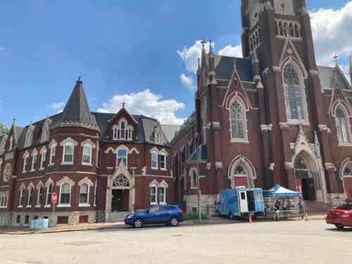
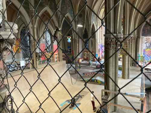
In my 32+ years in St. Louis I’ve seen too many great 19th century buildings fall apart due to neglect & abandonment. I’ve feared the loss of these. But the former convent is owned by Karen House, a catholic worker house. The sanctuary & rectory are owned by SK8 Liborius — a skate park.
The interior of the church was stripped after closing in 1992. It’s great seeing indoor ramps in the space. Photo by David Frank.
The other use for an old sanctuary I’d like to see would be as a vertical hydroponics farm.
A decade ago the National Geospatial-Intelligence Agency (NGA), located near Anheuser-Busch brewery, announced it intended to build a new campus. If you’re not familiar with the NGA here’s how they describe themselves:
The National Geospatial-Intelligence Agency (NGA) delivers world-class geospatial intelligence that provides a decisive advantage to policymakers, military service members, intelligence professionals and first responders.
Anyone who sails a U.S. ship, flies a U.S. aircraft, makes national policy decisions, fights wars, locates targets, responds to natural disasters, or even navigates with a cellphone relies on NGA.(NGA)
b
b
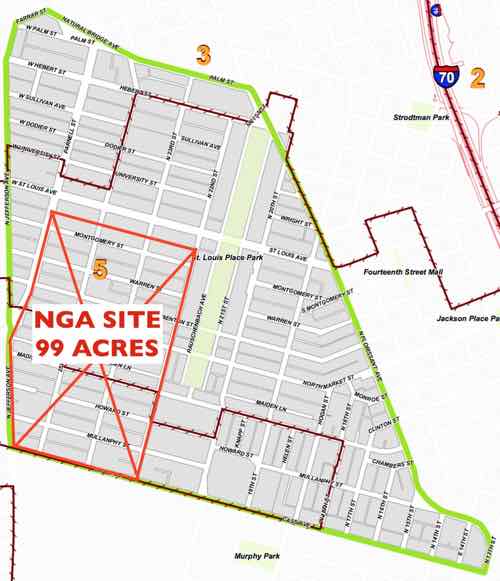
The NGA site is a big chunk of the St. Louis Place neighborhood. The latest documents call it 97 acres, not 99 on this image used in a prior post.
b
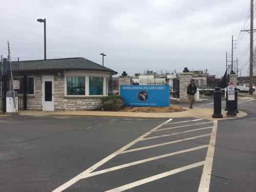
I just couldn’t see how building a large high security military facility was going to be a positive for the immediate area — people would drive in for work, maybe drive out for lunch, then drive home at night. Having seen the secure entrance to their current facility numerous times it’s not welcoming, nor pedestrian oriented.
Current NGA entrance, 2015
This February 2016 concept was prior to the final decision of the St. Louis Place site in April 2016
In the concept above we see structures in the center of the site, not edges — for security. In the very center is 7 separate buildings, with a parking garage to the north & south (left & right). If you’ve been watching the construction taking place you know NGA’s actual design is different than St. Louis’ concept rendering. Again, the concept above was part of the successful St. Louis effort to have the site at Jefferson & Cass selected.
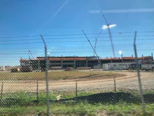
Construction of a parking garage in September 2021, as seen from the #04 Metrobus
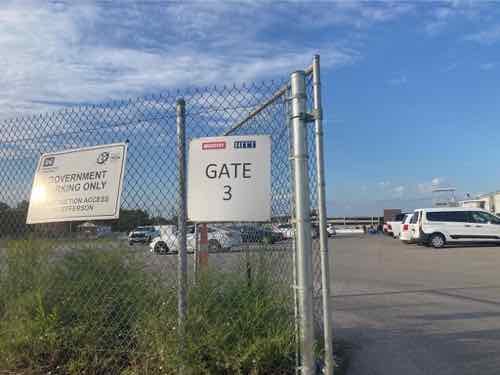
Last month us residents participating in the process to create new plans for the 6 neighborhoods around NGA (St. Louis Place, Old North, Hyde Park, JeffVanderLou, Carr Square, and Columbus Square) were invited on site for an open house.
The open house was at Gate 3, off of Cass Ave. There was a presentation in the parking area, then we got to go up into the viewing tower on the right for a better view. Yes, I slowly walked up the flight of steps.
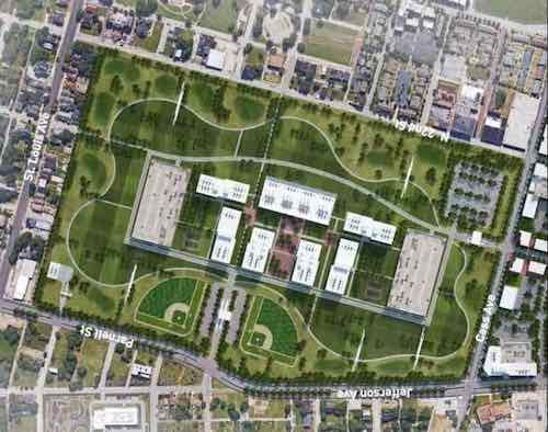
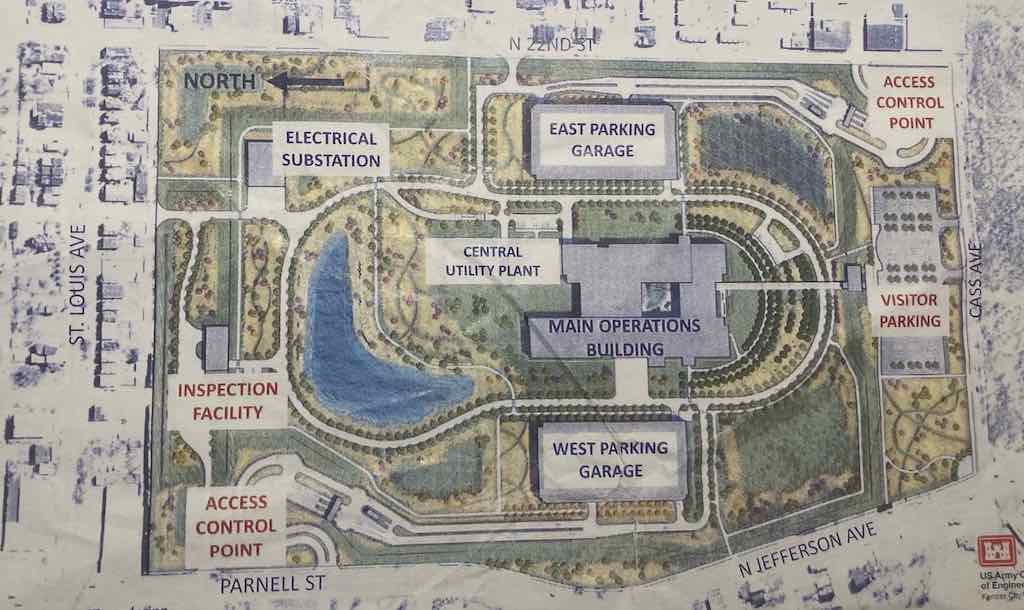
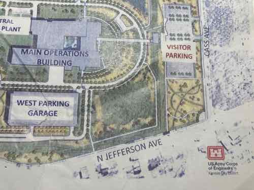
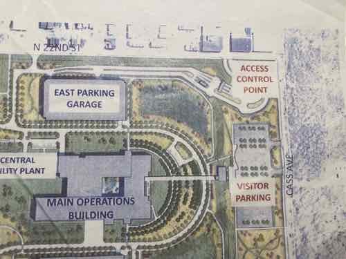
Photography & video were not allowed, but we were given a site plan for the actual design. To my knowledge this is the first site plan the public has seen of this project.
Site plan distributed last month, click image to see a larger version.
Finally seeing what the NGA is actually building gives my some hope that it can potentially have a positive impact on the trajectory of North St. Louis. My concern had been this becoming a big barrier, especially once the intact street grid was erased. Well, it’s still a barrier but the employees within the grounds will have opportunities to come & go relatively easily as pedestrians. Hopefully this will translate to businesses east, south, and west of the site.
I was also concerned about a line of cars on Jefferson Ave to enter the site.
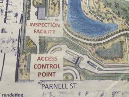
There will be two “Access control points” for those driving to work — one in the NW & SE corners of the site. Each has a curved drive to give cars room to queue up without blocking through traffic on Parnell or 22nd. This design also means vehicles can’t get a good straight run at trying to crash through the gate. All cars entering the facility are examined, especially for explosives.
The inspection facility in the NW corner will allow trucks with deliveries to unload and leave out the alley on the north. Items will be inspected before being loaded onto a secure truck for delivery to the main building.
You can see a sidewalk out to Jefferson. The SW corner of the site is the intersection of Jefferson & Cass avenues. The security fencing will be set way back from Cass to allow a corner park/plaza space and visitor parking. A park that’s not behind a security fence? They’ll allow visitors?
A visitor’s center will be adjacent to the visitor parking. This center is where guests will go through security. Apparently the main building is compartmentalized such that visitors can be allowed in part without risking security in the remainder. It will have an outdoor courtyard in the center of the building.
The SE corner of the site (22nd & Cass) is the other access control point — accessed via 22nd Street, not Cass Ave. Along 22nd Street is where I hope to see businesses in the existing buildings, or maybe urban new construction. Perhaps places workers see driving in/out so they decide to walk to them at lunch.
I think 22nd & Cass will likely become a signalized intersection, possibly another at the other access point. I use the #32 bus along Cass Ave at times so I’m curious about the nearest bus stop to Jefferson — right now the westbound bus stop is before 22nd Street, so a long distance from Jefferson. No bus stops are shown on the site plan. Across Cass Ave to the south is the mostly vacant former Pruitt-Igoe site. How this gets developed will determine the long-term success of the area. I hope we don’t get a free-standing Starbucks with or without a drive-thru. A coffeehouse on the ground floor of a multi-story building on the SE corner of Cass & Jefferson would be great.
Knowing NGA employees can get in/out of the site pretty easy as a pedestrian is encouraging. The construction will be finished in 2025, the NGA expects to relocate to this new facility in 2026.
AARP Livibility Index
The Livability Index scores neighborhoods and communities across the U.S. for the services and amenities that impact your life the most
Built St. Louis
historic architecture of St. Louis, Missouri – mourning the losses, celebrating the survivors.
Geo St. Louis
a guide to geospatial data about the City of St. Louis