How To Address North St. Louis’ Shrinking Population

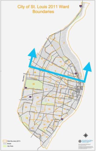
The 2020 Census results results for St. Louis showed what I had predicted, the bulk of our population loss came from northside wards. This was also true in 2010 and in 2020. No reason to think 2030 won’t be more of the same. We can sit back and do nothing, or we can help manage the situation — possibly reducing some losses in future.
By mange I mean see where population is dropping more than in other areas. We can’t just write of a third of our geographic area. I propose a group comprised of experts, residents, business owners, etc to examine data and evaluate possible solutions.
Here is some of the data I’d like to see on a big map(s):
- Population by age & race
- Parcels of land being used (water connection) vs unused.
- Parcels of land with new or substantially renovated structures vs severally deteriorated, condemned, or vacant.
- Parcels of land owned by the city, out of state owners, owner-occupied, LLC, .
- Historic properties, sites.
- Schools, current & former.
- Employers and numbers of employees
- Crime
- Topography
- Probably other criteria as well…
Since north city is not declining uniformly we need to see which parts that are doing better than others. Is this because 0f newer housing? Access to transit? All we know at this point is some blocks are stable and occupied while others are rapidly declining. Mapped data can tell us a lot, people on the ground familiar with their area can confirm or dispute what the data tells us. Get everyone on the same page, then reassess every few years and make adjustments as circumstances change for better or worse.
What we all need to accept is that it’s very unlikely these neighborhoods will see a major population growth. Ever. Thus some land can be returned to nature, used for agriculture, etc. The maps will show us the least populated areas with the worst housing stock — contrasted with pockets of denser areas with housing unlikely to be abandoned this decade. I’m not talking about large areas the size of Pruitt-Igoe, NGA-West, or Fairgrounds Park. It might be possible that smaller nature areas could be linked together by a trail system. A few great vacant school buildings not reused for residential might get filled with hydroponics to grow produce.
The major corridors like MLK, Page, Natural Bridge, Kingshighway, Grand, etc should remain. Many connecting streets would also remain. However, it’s possible in some areas we might be able to justify removing unoccupied streets and alleys. As St. Louis begins to look at replacing lead water supply lines those areas that’ll benefit most from the infrastructure investment should get priority over areas that can be back to nature by 2030. Old water & sewer lines might get abandoned completely in isolated areas.
The goal isn’t to cut off services to existing residents, but to use resources to strengthen and grow the existing strong pockets. On a block with say only one resident we can wait until that person moves or dies of old age. The children of longtime residents aren’t really interested in moving into the house their relative refused to leave. Conversely, a nice block with one newly-abandoned house needs help to make sure that one house gets maintenance and reoccupied as soon as possible. Quickly reoccupying a vacant building helps prevent others on the block from also being abandoned.
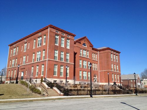
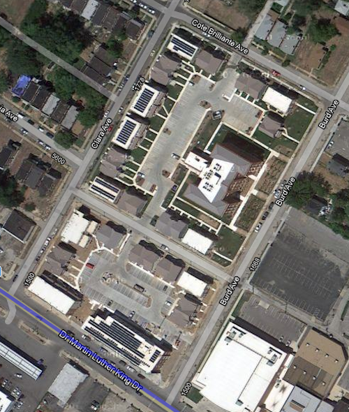
An example of a strong pocket would be MLK & Burd Ave. You’ve the Friendly Temple church and Arlington Grove housing (new housing around a renovated school that’s also housing). Substantial investment has been made, and this is home to many. We can reinforce the positives and look to expand upon that a block at a time.


Just north of this pocket is a largely vacant area, part of the Wells-Goodfellow neighborhood that has gotten attention for mass demolitions. Other bright spots throughout north St. Louis include numerous tree-lined streets with well-maintained houses — it’s just hard for everyone to see & appreciate the them with so much decay. Whenever I see people wanting to raze vacant “problem” buildings I do get upset, because tearing down buildings in a random manner doesn’t improve neighborhoods for the long-term. It simply removes the current problem while likely speeding up others being abandoned as neighboring owners/residents die or move. By designating different areas for bright spot village and others as moving back toward nature we can reduce fights over razing vs preservation. I can even imagine a decent house in an area set to become nature/agriculture –it might be kept as basically a farmhouse. It wouldn’t necessarily be razed, just reimagined.
Along the way we can reevaluate I-70, an old interstate that winds its way through north city. Can we minimize this as a separating barrier in spots? Can we create areas for interstate drivers to pull off and get a bite to eat while their battery electric vehicle (BEV) charges?
One spot I see as the center of a future village is the intersection of Grand & North Florissant. That’s in part of 2 current neighborhoods, with a 3rd very close. It should be the very center of a thriving area.Why here? The intersection of two corridors should be treated as special. Both Grand and North Florissant are angled toward each other, so a person living or working here can pick either corridor to travel south — southeast on North Florissant or Southwest on Grand. Thanks to the odd street grid they have easy direct access to different parts of the city. Going northwest on North Florissant will eventually get them into St. Louis County.
By 2050 I see north St. Louis as being dotted with nice little villages, with nature in between. Primary corridors will be a line of density with restaurants, retail, offices, and multi-family housing. Rail &/or rubber tire public transit will connect these villages to each other and the larger city & region. I see walking & biking within and between villages. I see jobs growing produce outside and indoors, more jobs along the corridors. I see trees — thousands of them providing some relief from increased temperatures. The major corridors will be tree-lined, many new nature areas will become forests. I see all races, proportional to the mix in the population. Some villages, like The Ville, are predominantly black (75%, not 100%) with strong black-owned businesses. Again I’m talking 30 years, not 3.
What I don’t see are big surface parking lots for big box chain stores. I also don’t see blocks and blocks of obvious vacant residential buildings/lots.
St. Louis should use some of the money from the NFL to kick start the planning process to examine north St. Louis as I’ve described — taking stock and what we have (and don’t have) and then collectively finding solutions to change the trajectory. In the process others could come up with better ideas.
— Steve Patterson