September 6, 2015Economy, Featured, Politics/Policy, Sunday PollComments Off on Sunday Poll: The Missouri legislature may attempt to override Gov Nixon’s June veto of right-to-work legislation. Which side are you on?
Please vote below
The national fight over ‘right-to-work’ has come to Missouri. In June Gov Nixon vetoed such legislation:
Missouri did not become the country’s 26th “right to work” state Wednesday: Gov. Jay Nixon issued a veto, setting up a clash with the state’s Republican-led Legislature.
The bill would have made it a misdemeanor for anyone to be required to become a union member, or to pay dues to a labor organization, as a condition of employment. Nixon, a Democrat, was expected to block the legislation, leaving state lawmakers to round up enough votes to override him. (LA Times)
I’m not going to get into the pros & cons now, I’ll save my views for Wednesday. In the meantime, I thought this would be a good topic for today’s poll:
The answers are presented in random order, the poll closes at 8pm.
Last weekend was the 10th anniversary of Katrina hitting the Gulf Coast:
Hurricane Katrina surprised disaster preparedness authorities when it made landfall 10 years ago, leveling entire communities and killing more than 1,800 people. The storm caused more than $100 billion in damage, making it the costliest natural disaster in U.S. history. But for all the damage the storm caused in New Orleans, Katrina was a relatively weak hurricane when it hit the city.
In the academic community, the unexpected disaster prompted climate scientists to consider the link between climate change and storms. Since then, research has shown that climate change will increase the devastation caused by hurricanes as sea levels rise due to global warming. Some research has also suggested that climate change has increased the intensity and frequency of storms. (Time: Why Climate Change Could Make Hurricane Impact Worse)
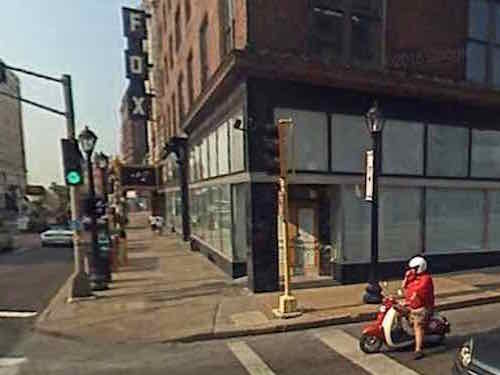
After watching video of the resulting destruction I knew I had to do something, but what? My solution was to buy a nearly-new Honda Metropolitan scooter, 49cc. I did so ten years ago today!
Most scooters get very high fuel economy, I regularly got between 80-95 mpg. Over the next 29 months I put about 5,000 miles on that scooter — driving all over the region. Eventually it allowed me to go car-free!
Google Streetview captured me on my scooter in September 2007
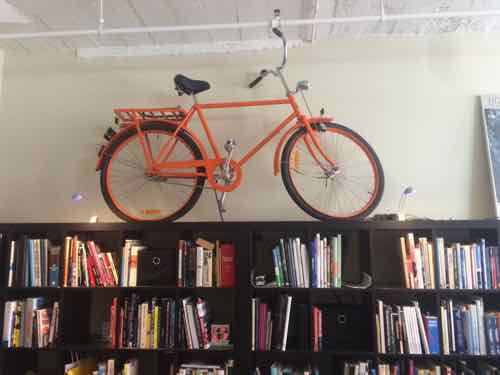
On February 1, 2008 my scooter days came to an end, 15+ hours of no help following a hemorrhagic stroke left me able to ride scooters or bicycles. I sold the scooter to a neighbor — he eventually got another with a larger engine. I also sold all my bicycles — except one.
I kept my reproduction WWII Swedish Army bike, it’s now art in our home office. Click image for Wikipedia article on Kronan bikes.
I have many fond memories of riding both the scooter and the orange bike. New poll on Sunday — have a great weekend!
On Tuesday SSM Health took over Saint Louis University Hospital from Saint Louis University, at the same time announcing plans to construct a new facility:
SSM Health plans to invest $500 million to build a new St. Louis University hospital and ambulatory care center.
The new facilities, which will be situated in the immediate vicinity of the current 365-bed hospital near the midtown campus of St. Louis University, will be completed within five years, SSM officials said. (Post-Dispatch)
Uncertainty of the existing Desloge Tower left many wondering if it might be razed.
Desloge Tower in 2011
First, some background:
Going back in the history books, Firmin Desloge Hospital was officially dedicated on November 3, 1933, rising 250 feet and topped by a French Gothic roof of copper-covered lead. Over the next several weeks, it began admitting its first patients. It was unique for its time, offering patients private or semi-private rooms instead of the open ward model common in most hospitals. Desloge Tower served as the main hospital building of the Saint Louis University Medical Center until 1959 when Firmin Desloge Hospital, the Bordley Memorial Pavilion and the David P. Wohl Sr. Memorial Institute were collectively renamed Saint Louis University Hospital.
Desloge Tower is also home to the chapel of Christ the Crucified King, commonly known as Desloge Chapel, which was designed by Gothic revivalist architect, Ralph Adams Cram, who was a prolific and influential American architect of collegiate and ecclesiastical buildings. The chapel was designed to echo the contours of the St. Chapelle in Paris, which was Louis IX’s palace chapel, and in 1983, Desloge Chapel was declared a landmark by the Missouri Historical Society.
Desloge Tower continues to serve SLU Hospital with physician offices, gastroenterology, interventional radiology and the cardiac catheterization lab.
Its image is a well-recognized part of the St. Louis skyline, and is often the symbol of the hospital itself. (SLU Hospital)
With a fresh start nearby, it does mean the future is uncertain. The future of the old Pevely Dairy just to the North is more certain — it’ll likely be gone.
The former Pevely Dairy at Grand & Chouteau, 2011
I’m fine with the Pevely coming down — as long as the new facilities are very urban in form. This is on the route of the busiest MetroBus route in the region — the #70 (Grand), and the #32 (ML King-Chouteau) runs in Chouteau. Just to the North is the Grand MetroLink (light rail) station.
Westbound #32 MetroBus on Chouteau just barely west of Grand. The Pevely bldg is to the left. 2012#70 MetroBus riders at the Grand MetroLink station, August 2012. Dislodge Tower can be seen in the distance
What many in St. Louis, especially at City Hall, fail to realize is facilities can be friendly to motorists and pedestrians — these are not mutually-exclusive. The street grid need-not be decimated to create a campus.
Looking east along Erie St at Fairbanks, Chicago IL
When we visit Chicago next month, our 4th time in 2015, we’ll be staying in a friend’s condo located within the Northwestern Medicine/Northwestern Memorial Hospital campus. The sidewalks are packed with people visiting street-level restaurants. The internal walkway system and lots of parking garages hasn’t made the sidewalks a ghost town.
SSM Health is going to build a new complex. Now’s the opportunity to look at how medical campuses in other cities can be vibrant active places that are also convenient to those using cars. Dislodge Tower could become a mixed-use building with retail, restaurants, offices, and residential.
Over half of those who voted in the most recent Sunday Poll got it correct — we’ll definitely be affected by Climate Change. How can I be so sure? It was a trick question — we’re already being effected by it! First, the poll results:
Q: Think you will be personally affected by Climate Change within the next 20 years?
Definitely 20 [58.82%]
Possibly 6 [17.65%]
Doubtful 5 [14.71%]
Certainly not 2 [5.88%]
Maybe, maybe not 1 [2.94%]
Unsure/No Answer 0 [0%]
Far too many people see headlines taking about what will happen by the end of the century and think they won’t be effected — few of us will be alive in the year 2100 — I certainly won’t be. But that view ignores the fact the changes have already begun and will continue unless the world takes big steps to slow it. Different regions will be effected differently, but the global food supply is the great equalizer.
California is a big supplier of foods to the rest of the country — so we’ll feel changes in St. Louis: either in our wallet or lack of availability. From August 18th:
The UC Davis team used computer models and the latest estimates of surface water availability from state and federal water projects and local water districts. They forecast several drought-related impacts in the state’s major agricultural regions for the current growing season, including:
The direct costs of drought to agriculture will be $1.84 billion for 2015. The total impact to all economic sectors is an estimated $2.74 billion, compared with $2.2 billion in 2014. The state’s farmers and ranchers currently receive more than $46 billion annually in gross revenues, a small fraction of California’s $1.9 trillion-a-year economy.
The loss of about 10,100 seasonal jobs directly related to farm production, compared with the researchers’ 2014 drought estimate of 7,500 jobs. When considering the spillover effects of the farm losses on all other economic sectors, the employment impact of the 2015 drought more than doubles to 21,000 lost jobs.
Surface water shortages will reach nearly 8.7 million acre-feet, which will be offset mostly by increased groundwater pumping of 6 million acre-feet.
Net water shortages of 2.7 million acre-feet will cause roughly 542,000 acres to be idled — 114,000 more acres than the researchers’ 2014 drought estimate. Most idled land is in the Tulare Basin.
The effects of continued drought through 2017 (assuming continued 2014 water supplies) will likely be 6 percent worse than in 2015, with the net water shortage increasing to 2.9 million acre-feet a year. Gradual decline in groundwater pumping capacity and water elevations will add to the incremental costs of a prolonged drought. (UC Davis: Drought costs California agriculture $1.84B and 10,100 jobs in 2015)
But foods are grown many places:
Warmer temperatures may make many crops grow more quickly, but warmer temperatures could also reduce yields. Crops tend to grow faster in warmer conditions. However, for some crops (such as grains), faster growth reduces the amount of time that seeds have to grow and mature. [1] This can reduce yields (i.e., the amount of crop produced from a given amount of land).
For any particular crop, the effect of increased temperature will depend on the crop’s optimal temperature for growth and reproduction. [1] In some areas, warming may benefit the types of crops that are typically planted there. However, if warming exceeds a crop’s optimum temperature, yields can decline. (EPA: Agriculture and Food Supply)
It’s foolish to think we won’t be affected in the next two decades.
Here the Midwest:
The Midwest is home to roughly 66 million Americans and includes the cities of Chicago, Indianapolis, Detroit, Milwaukee, Kansas City, Cleveland, Minneapolis, and St. Paul, among others. Most of the region consists of flat prairie that is farmed for corn, soybean, and wheat, or is used for grazing livestock. Summers in the Midwest are hot and humid, and winters are cold, since the region is far from the temperature-moderating effect of the oceans. [1]
In the Midwest, average annual temperatures increased over the last several decades. Heat waves are becoming more frequent and cold periods are becoming rarer. Snow and ice are arriving later in the fall and starting to melt earlier in the spring. Heavy downpours now occur twice as frequently as they did a century ago.[1] These trends are likely to continue under future climate change: average summer temperatures are projected to increase by 3°F over the next few decades and could increase by over 10°F by the end of this century. This range would make summers in Illinois and Michigan feel like those in present-day Texas and Oklahoma, respectively. [1] http://www.epa.gov/climatechange/impacts-adaptation/midwest.html
In St. Louis our air quality will deteriorate further.
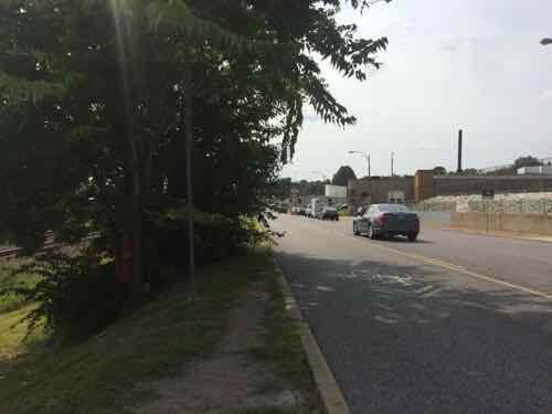
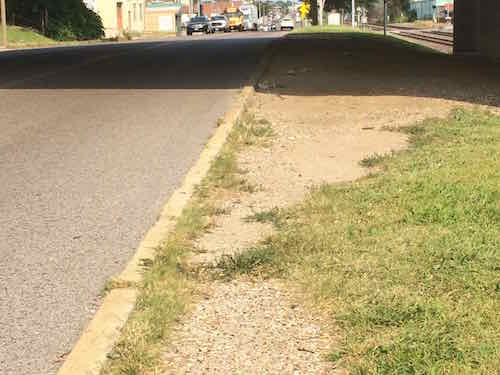
Last week I was near Manchester & Hampton doing research, I arrived & departed on the #32 (ML King-Chouteau) MetroBus. Arriving the bus was headed West on Manchester, so the stop was on the adjacent sidewalk. For the return trip I needed to catch the bus as it headed East on Manchester — no sidewalk on that side. But there is a just big enough concrete pad. I didn’t get a pic from across the street but you can see it on Google Street View here.
It took a while but I finally got a break in traffic where I could quickly cross Manchester to the stop I needed.
Looking North from Metro Stop ID: 13572Looking West I was concerned the bus driver wouldn’t be able to see me. A path was worn in the grass from others using this stop.The ground was also worn East of the stop.
I was right at the edge waving as the bus approached. Another passenger got off at my stop so she stood close to my wheelchair on the small pad while the driver extended the lift so I could board. Would the driver have seen me if a passenger wasn’t wanting to exit at my stop?
I had wanted to go to the next stop to the East where I could cross at a crosswalk, but vegetation (upper left of last photo) blocked the sidewalk.
So who’s responsible?
Metro
MoDOT
St. Louis
All three are involved, but fragmentation means the pedestrian experience here sucks. The quick solution is to trim the vegetation in both directions. A crosswalk with warning signs for motorists to stop for pedestrians would be relatively cheap. I’m going to email Ald. Vollmer (10th) & Ald. Ogilvie (24th) to let them know about the issues here.
AARP Livibility Index
The Livability Index scores neighborhoods and communities across the U.S. for the services and amenities that impact your life the most
Built St. Louis
historic architecture of St. Louis, Missouri – mourning the losses, celebrating the survivors.
Geo St. Louis
a guide to geospatial data about the City of St. Louis