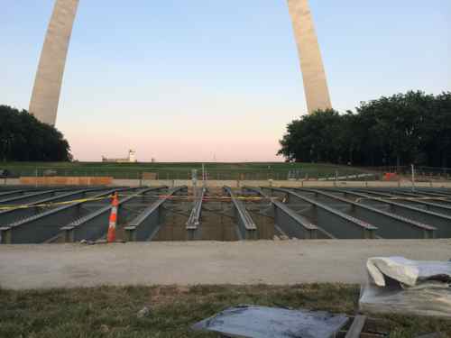
Lid Over Highway Takes Shape, Old Elevated Highway Needs To Be Replaced With At-Grade Boulevard
The long-desired “lid” over the depressed section of the highway is now taking shape.
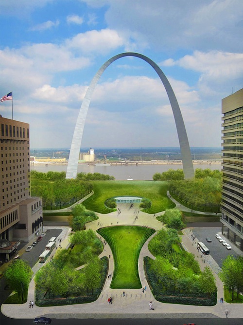
Once completed you’ll enter the museum on the opposite side, through an opening in the grass mound. See the drawing below:
Orienting the museum toward the city is the correct thing to do, just as making the highway a boulevard in the future. The lid will allow visitors to cross a boulevard at the center, my primary objective is to remove the elevated section north of Washington Ave/Eads Bridge. This stretch was known as I-70 for decades, but once the new Stan Musial Veterans Memorial Bridge opened it was renumbered I-44.
Though many of us would’ve like this to have been concurrently planned, we’ll just need to keep pushing.
— Steve Patterson
If Amendment 7 included funds to tear down the I-70 elevated lanes and build the boulevard, I might have voted for it. As it is, this proposal has no serious political support, so you might as well forget it. This project is to focused and specific. Politicians prefer things to be vague and general. It’s easier to avoid accountability that way. Want proof? Just listen to this year’s crop of campaign ads.
The reason I-44 is elevated here is because of the Metrolink (old railroad) tracks under Washington Avenue. To connect I-70 to the north and I-55 to the south, there are three options – the current elevated freeway, taking the depressed section even deeper, under the Metrolink tracks or doing an at-grade boulevard for approximately 10 blocks, between roughly Locust and O’Fallon. The first two options maintain the freeway, the at-grade option eliminates the free flow of traffic. Convincing MoDOT to eliminate the freeway north of the lid, after they invest the money to do the lid, is wishful thinking at its finest. And expecting MoDOT or the taxpayers to do a “big dig” to bury the freeway between a football stadium and a casino is just as crazy.
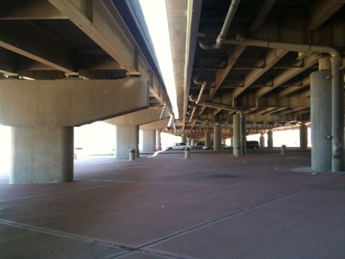
The real barrier, here, isn’t the raised section, it’s the two transition areas, from depressed to raised, and from raised to depressed. Walking under the raised section is “bad”, now, NOT because of the freeway above, but because of the boulevard-like traffic on the mess of city streets underneath it – 3rd, 4th and the two bridges, all with multiple lanes to cross, simply isn’t very inviting to pedestrians, both from dodging traffic and the distance between things that aren’t just vehicle-related stuff. Lake Shore Drive in Chicago is a boulevard, like you envision, but it functions much like a freeway. For pedestrians, it means using tunnels to get from one side to another. It may be prettier, but it’s still a barrier. A boulevard, here, would be the same thing, a high-speed transportation corridor, and not much more pedestrian friendly. But if you really want to look at making an elevated freeway go away, how about talking about I-64 between Busch Stadium and Union Station?
I think a boulevard isn’t even needed here. Replace the elevated freeway section south of the new river bridge with development, not pavement. The depressed section could be converted to an extended exit off I-44/55 to Memorial Drive and Washington Avenue. MoDOT reversing the Memorial Drive ramps, make everyone enter/exit there with zero freeway or boulevard north of Washington Avenue. That would also save the cost of having to replace any PSB ramps to/from Memorial Drive, and instead, free up those PSB outer lanes for doubling up the ramps to/from I-44/55. At the other end of the freeway removal, I-70 traffic wouldgo to either Tucker Blvd, Broadway or the new bridge.
While I stand by my belief that the freeway ain’t gonna go away anytime soon, I can also see potential in your concept IF (and that’s a very big IF) the designated through route were placed on 4th (northbound) and Broadway (southbound), and NOT along the current alignment (Memorial Drive, depressed section, etc.). This would require, new, direct, well-engineered ramps in the vicinity of Park and Hickory, along with minor changes around Cole / Carr / Biddle, and synchronized, sequential traffic signals along 4th and Broadway, but using a one-way couplet would do a MUCH better job of both moving traffic AND providing an improved pedestrian experience than two-way boulevard ever could.
The “through route” for national travel is across the river, not through downtown. Interstates 55 and 70 already cross the river without going through downtown. There is no reason to have a “designated through route” for national travel through downtown. Chicago’s Lakeshore Drive, an urban boulevard, carries more traffic than Memorial Drive, and it has many signalized intersections, where closest to downtown (the Loop). Even New York City doesn’t have a primary interstate traveling through Downtown or Midtown.
Hey, I can finally comment again, thank you internet gods! First of all congratulations on your marriage to David, I am happy for you.
One possibility could be stage an architectural competition for turning underneath the highway into a commercial district, maybe even with movable daily and weekly markets and importantly emphasizing surrounding access both from the Landing/Arch area and Downtown.
In any case some cheap solutions could be tried, you start moving highways and you practically need an act of congress, of course they will never get off their collective asses to do anything. (It’s a clown show at best)
So the question becomes, can an artistic, humane solution be found within the confines of the overhead highways?
^ No.
yes. In a number of cities there are buildings beneath highways or elevated rapid transit. No reason that cannot be done in st louis. except that
we are sometimnes called the city of “no”. There would have to be
some way for people to cross the mze of streets and bridge ramps
Thanks dempster, I didn’t know the proper reply to no, which I take it to mean who cares? I don’t get waiting for the big act, or big acts, I don’t get not taking control of the city. This Ferguson ordeal highlights more than ever the government is not working in the interest of the people.
Murals might also be a solution, I just meet a guy who worked in Soulard for awhile that does murals along with other art.
http://www.artbybryanhaynes.com/portfolio/murals/
Why can’t murals been done by the community in this area?The possibilities are endless.
I would rather let it become a self-made homeless community, it would probably be interesting than the city itself if allowed to develop.