Readers Split On Proposed Streetcar Route
Readers in the poll last week didn’t select any one option by a majority. The three routes presented as options, two being considered and another I’ve been advocating for years, each received a similar number of votes.
Q: My preferred route for a streetcar line is…
- Option 2: Olive/Lindell>Euclid>Forest Park Blvd>Taylor>Lindell 35 [29.66%]
- Option 1: Olive/Lindell>Taylor>Children’s Place/CWE MetroLink 31 [26.27%]
- New option: Olive/Lindell to Vandeventer to Delmar to Loop Trolley 29 [24.58%]
- None, don’t built a streetcar line 12 [10.17%]
- Other: 10 [8.47%
- Unsure/No Opinion 1 [0.85%]
The ten other answers were:
- Use the old Hodiamont Streetcar right of way
- grand blvd
- Olive/Lindell>Euclid>Forest Park Blvd>Vanderventerr>Lindell/Olive
- Street cars are a joke. They are a waste. Busses offer far more flexibility.
- Use the old Hodiamont street car right of way.
- Continue on Lindell to Debaliviere/Loop Trolley connection.
- Middle-upper income routes to replace cars.
- Link “downtown” only by s.cars: riverfrt. to Jeff Ave,, Delmar to Soulard.
- free, downtown loop, between Tucker & Broadway
- Option 1 but utilize Market and Forest park instead of Olive/Lindell
When streetcars were first installed it was a private effort by real estate developers to make it easier for buyers to reach new development:
The Gravois-Jefferson Streetcar Suburb Historic District is located within the boundaries of the City of St. Louis, Missouri. The -715-acre District is a triangular area generally bounded by the intersection of Gravois and South Jefferson Avenues at the north, South Jefferson Avenue and South Broadway Street (south of Chippewa Street) on the east, Meramec Street on the south, South Grand Boulevard on the west, and Gravois Avenue on the northwest.’ Gravois Avenue is a major arterial street and historically served as a wagon, streetcar, and vehicular transit corridor. South Jefferson Avenue also was and is a major transportation corridor. Meramec Street is a major collector street. Mixed commercial, institutional, and residential use along these major city thoroughfares visually and historically defines the survey area. (National Register nomination PDF)
Today funding streetcars in developed urban areas takes more than available right-of-way, it takes enough demand to justify the investment in infrastructure. Often this means connecting some big dots, the in between will fill in over time with proper land use controls. The problem in St. Louis is our big dots are generally east-west between downtown and Clayton. What big dots exist north & south to guarantee ridership on a daily basis?
Grand has a few dots:
- VA Hospital
- Grand Center/SLU
- Grand MetroLink
- SLU Hospital
Okay, suppose you connect these via streetcar — that’s a mile and a half length. Not bad, but you’d still have to run the #70 (Grand) MetroBus to reach areas north and south — an additional 7.5 miles. Even my longtime preferred route of Olive/Lindell to Vandeventer to Delmar doesn’t have enough dots to get funding.
But between the Option 1 & 2 being considered I have a strong preference for #1 — the double track on Taylor Ave option rather than the Euclid/Forest Park/Taylor loop.Establishing a double track on Taylor Ave sets up a perfect scenario for north-south expansion. Below is one concept:
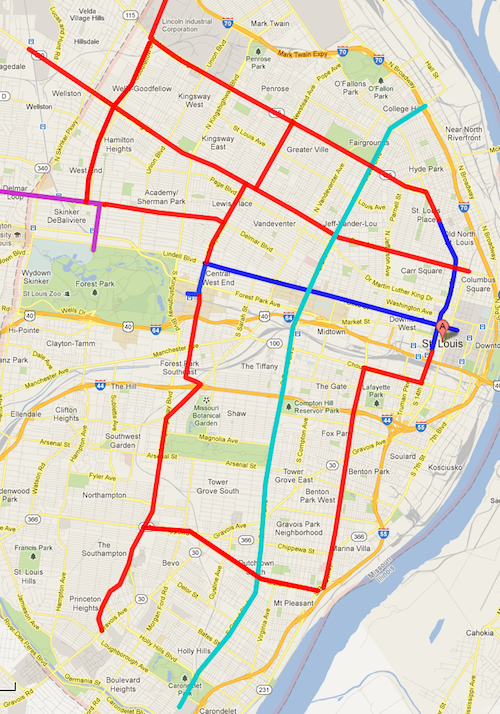
The dots aren’t there for an initial north-south line but extending a couple of miles here and there every few years would eventually build a system. The current proposal calls for a north-south piece at 14th Street, going up to St. Louis Avenue. The double track on Taylor of Option 1 provides an ideal spot for a second north-south line further west. Expansion could happen to reach new development projects.
Yes, what I’ve shown above would take decades to construct. That’s how long-term planning works. For further reading on streetcars please see a 65-page literature review of Relationships Between Streetcars and the Built Environment.
— Steve Patterson
By “big dots”, I assume you mean employment centers. What’s interesting about the routes on your map is that they mainly just follow existing, low-density, auto-centric retail corridors, essentially replicating existing bus routes, or worse, run a few blocks away from existing corridors – 14th instead of Tucker, Taylor instead of Euclid or Kingshighway. The routes appear to ignore the CBD, east of Tucker, and barely touch on the BJC Hospital complex. I get that you want to focus on using any investment in streetcars to jump start other investments in denser urban projects, but streetcars need to be more than silver bullets or magic fairy dust, they need to be, above all, viable transit options. What you’re proposing is more along the lines of the less-than-successful streetcar lines in Tampa, Memphis and Kenosha, and less like the successful lines in Portland, San Francisco or Toronto.
The other half of the equation is that the world has changed, significantly, over the past 100-135 years. As noted in the application for the Gravois-Jefferson Streetcar Suburb Historic District, “Although platted at irregular intervals over a fifty-year period beginning in the 1860s, residential development in the District actually occurred in a wholesale manner beginning in the late 1870s and continued through the early 1920s, with the greatest number of buildings erected between 1890 and 1910.” I agree, “When streetcars were first installed it was a private effort by real
estate developers to make it easier for buyers to reach new development.” People didn’t have Model T’s, much less SUV’s, they had their feet, bicycles and horses. If people couldn’t get to your product, you couldn’t sell your product.
These days, most people can and do drive, so developers invest in amenities that appeal to drivers. And, to appeal to drivers, transit needs to offer a better alternative (faster, cheaper, easier), not just “I’m here, use me”, we already have that with our bus system. Making it prettier and more “modern” will help, a little, but it’s going to take making driving a real PITA to convince most people to give up driving. Parking needs to be expensive and not readily available and traffic needs to be seriously congested – think opening day for the Cardinals. And until developers are forced, either by draconian government regulations or high land values (neither of which seem to be happening in the city), parking will remain an important part of any new development. Putting in streetcars, without any demand for more density, is no guarantee that density will follow, there needs to be a viable financial argument for both building and buying denser projects.
Your right. I can’t understand why we would spend hundreds of millions for something we already had and had out lived it’s usefulness. Want to test? Fine…I’m all for using trolleys as already in use in the park. IF and that’s a big if, the crowds are there to support the system, then I might be convinced to perma-build. And the crowds need to be residents. Those giving up their cars. Otherwise we’re just throwing pixie dust hoping something grabs some and sparkles. JZ is right about making it expnsive. But heck, they still have traffic out the wazoo in both LA and NYC…so no matter how expensive it gets, a great majority will still drive.
Many thought that the rise to $3.00 gas would translate to more Metro users. And for the short term it did, but we’re right back paying even more for gas and it’s not really fazing anyone. I seriously doubt if even $5.00 a gallon will dent car use. Sure, people will complain for the first few months, but then the budgets are adjusted, people adapt and it’s right back to normal.
While I despise the idea of our family spending north of $130.00 a week for gas, our family has chosen to budget accordingly in exchange for living in an area where we can keep five horses, two donkeys, a young grove of apple and peach trees and lots of space for a vegetable garden. It is true that I spend too much time for my work commute, and that we spend hours a day transporting the boys to school and to various other venues so they can pursue activities not otherwise available to us in our rural area, but FOR US the quality of life made available to us in this rural area is worth the expense and effort. Along with the inconvenience of driving, we have chosen also to educate the boys in private schools, only because I feel the local public schools in our area don’t demand a level of student performance that will be necessary for them to achieve future success. (In my opinion, the local Catholic school is not much better.) I am FAZED at the cost of gas, but even if gas costs increase two-fold, I would be willing to pay it. Perhaps if this Paul McKee issue ever gets resolved and large tracts of land in North St. Louis are made available for purchase, we can move closer-in, still have our horses and donkeys, fruit trees, etc. Until then, I’m doing my job to maintain Shell Oil, BP, AMOCO, Toyota and Honda’s profit margin.
Perhaps ‘fazed’ was the wrong word to use. I wanted to imply that even as gas gets more Expensive (and it will), people will adjust to it however they think right….could be less movies, less hair cuts, could even be cutting out certain types of food. But the bottom line is that it will take something very awful and very long to really get a majority of people to give up their vehicles or even give them up half time.
I think it’s great you’re living rural. You’ve made a decision good for you and the family. While I’m in the City and we love our neighborhood, and the neighbors, the area, the parks, and all that, the only reason we would consider moving (at this point) is a bigger yard….like 10 or 20 acres. Not something you find in the City.
I don’t have any expectation of a majority of adults in St. Louis ever using public transit as their main mode. Just getting 5-10% to switch would have positive impacts on air quality, reducing traffic congestion, accidents, etc.
I recently discovered this blog site, and it has triggered in me an interest in public transportation and city living. I was raised in a very small city in Alabama without buses or even taxi cabs. (Until four years ago, we had one policeman, who was also the mayor, and also ran the single gas station. So when he’d be out on police duty (which wasn’t often except on Friday nights), you’d have to sit around and wait for your gas. Oh, and he also read water meters!)So last Saturday, my wife and I decided to step out with our three young sons around 10:30 AM and do a bit of sightseeing in downtown St. Louis. We drove 15 miles to the Shrewsbury station, parked and caught the train. In a bit less than 30 minutes, we had arrived safely and without incident at the Savis train center. We visited the Union Station building and the water feature across the street, then admired City Hall and especially enjoyed the whimsy of the new, modern parking garage across from the police station. Great building! We ate lunch in the Italian restaurant in the lower level of the parking garage (really good, fresh pizza, also a new experience for us having come here from Alabama).From there we walked around St. Louis for the first time ever. We enjoyed the Wainwright skyscraper, Aloe Plaza and the new walking garden with all the water features and funky artwork. Then we walked to the Old Cathedral, where a nice older priest discussed the building’s history, then allowed us to view the interior. We walked further to the Arch and vowed to return at a later date for a trip to the top. From there we walked to Laclede’s Landing, where we had ice cream at a local shop, then noticed the Old Courthouse, centered on the Arch, and we walked back to take a look. My oldest boy recalled it as the site of the Dred Scott event. By this time I was carrying the youngest boy, and we were really tired of walking, but we managed to get over to Washington Avenue to view the renovated warehouse loft buildings. We saw City Museum but decided to save that one for another full day. We decided to stick around for dinner at a restaurant located near Fitness Factory gym, where we enjoyed really great hamburgers and perfect french fries, sat in the picture window and watched all the action on Washington Avenue. It was getting chilly and we decided to head back, found a metro station not too far away, boarded, and were back in Shrewsbury in less than 30 minutes……and all this got me thinking: It would have been great to purchase an all-day transportation pass for each of us, which would have allowed us to ride a bus or streetcar around the City. Would have saved lots of steps and (maybe) taken some of the stress out of the excursion. …just my thought…
What a wonderful story, thanks for sharing. Very glad you were inspired to use transit and walk around downtown! We don’t have a streetcar yet but the downtown trolley bus would’ve saved you some walking. Metro does sell day passes, so that was an option in the ticket machine. Also remember that kids under 5 ride free and kids 5-12 get the reduced rate fares. See http://metrostlouis.org/FaresPasses/FareChart.aspx
@Steve and Melanie: Thanks for the information on all-day passes. We should really have done more research prior to setting out, but we tend to be spontaneous. We’ll be back to enjoy more of the sites referenced in your post, Melanie.
Tom & family – Sounds like you had a great day! I admire your spirit of adventure and hope more people will follow your example. FYI – ALL-DAY PASS exists on Metro for $7.50 per person! Metro is a system, not just a train. This pass gives you access to all buses including #99 the Downtown “Trolley” which makes continuous loops from Civic Center to City Museum via City Garden, Old Courthouse, & Washington Ave. with short walks to other places of interest. http://metrostlouis.org/Libraries/Metrobus_Maps/Map99031113.pdf With advance planning (at Metro’s website, or the MetroRide store at 7th & Washington) you can connect at Civic Center to buses for Soulard, Lafayette Square, Crown Candy, Forest Park, Delmar Loop, etc. but there is really plenty to see downtown in one day. (Did you find the Old Post Office at 9th & Locust? fabulous preservation through adaptive re-use with PUBLIC RESTROOMS and a tiny museum.)
The current interest in streetcars ignores the Metro system already in place. I would love to see streetcars again throughout St Louis – not just in corridors of affluence and influence – but installing separate systems means buying separate fares. For those of us who live, work, and travel in the city every day without a car this would be an expensive disadvantage – also an insult to all those who have worked to improve and expand Metro in the last 25 years.
I still think that one of the smartest options would be to create a street car (or better yet, Bus Rapid Transit with dedicated lanes and signal prioritization) line from Downtown to Affton via Gravois and north on Tucker and Florissant to North County.
p.s. to Tom and other travelers: A day-pass for the #99 “Trolley” is $2 per adult. So if you use MetroLink and then travel in downtown only, your total fare would be $6.50; half-price for children 5 – 12, free for under 5. The $7.50 Metro Pass includes ALL buses – your MetroLink driver announces all the connections at each station, but you really have to do some homework to use them efficiently. Metro’s on-line TripFinder, or Google Transit, will help you get started. There are 7-day and 30-day Metro Passes also. Have fun !!