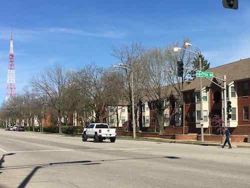
Looking west on Cole from 7th, the lights all the way down at least to 9th are on
In the meantime I looked back through old Google Streetview images and found the lights were as early as August 2018, but not a year earlier. So all we know is the lights have been on 24/7 since sometime after August 2017.
Finally on the afternoon of June 25 I noticed the street lights were off. I was so thrilled I shared on Facebook.
?In April I reported to the city how the streetlights in the Columbus Square neighborhood were on 24/7. They’d been on…
And yes, they came on at night just like they’re supposed to. I was very glad I’d help correct a highly wasteful situation!
However, my joy only lasted a week and a half. On July 6th the lights were back on 24/7 again.
A street light on our street was back on the afternoon of July 6, 2019
What I still don’t know is the location of the subterranean switches for the entire neighborhood. I also don’t know what kind of timer controls street lights for an entire neighborhood.
I just want the city to replace the burned out lights and then get them working correctly for more than a week and a half.
The worst effects of climate change are still decades away, but we’re starting to get a glimpse. While I hope the US gets on board with the rest of the world to slow/stop it before it’s irreversible I’m not optimistic that’ll happen.
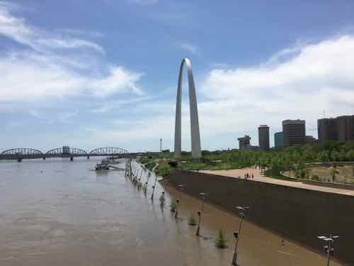
The St. Louis riverfront the afternoon of May 5, 2019
So my mind has turned to what should cities, specifically St. Louis, do to mitigate the negative effects. First, we have to determine what we might expect in the future.
The Midwest has gotten warmer, with average annual temperatures increasing over the last several decades. Between 1900 and 2010, the average air temperature increased by more than 1.5°F. The rate of increase in temperature has accelerated in recent decades, particularly nighttime and winter temperatures. Projected change in summer temperatures under different warming scenarios. Summers in Illinois and Michigan might feel like current summers in Texas or Oklahoma by the end of the century.
Precipitation is greatest in the eastern part of the Midwest and less towards the west. Heavy downpours are already common, but climate change is expected to intensify storms and lead to greater precipitation across the entire region during this century. Annual precipitation has already risen by as much as 20% in some areas. Projections of future precipitation indicate that heavy downpours are likely to occur primarily in winter and spring months while summers will become drier, especially in the southern portion of the region. (EPA)
Warmer year around, with wetter & dryer periods. So? From the same source:
In the Midwest, climate change is expected to negatively affect human health in a variety of ways and exacerbate existing health challenges. Major heat waves have been occurring more frequently across this region for many decades, resulting in increased deaths during these extreme events. Heat stress is likely to increase in the future as a result of continued rises in temperatures and humidity in this region, resulting in more heat-related deaths and illnesses. Air quality is already poor in parts of the Midwest and is projected to worsen with rising temperatures. Increased exposure to allergens caused by the lengthening of the pollen season is also expected to negatively impact human health.
Warmer temperatures and changes in precipitation could increase the risk of exposure to diseases carried by insects and rodents. Drinking water quality may also decline as a result of heavier rainfall events.
More on drinking water:
Precipitation in the Midwest is expected become more intense, leading to increased flood damage, strained drainage systems, and reduced drinking water availability. Midwestern cities with impervious infrastructure may result in surface runoff entering combined storm and sewage drainage systems. When these systems are overloaded during intense rainstorms, raw sewage overflow can result, impacting clean water availability and human health.
More heavy downpours may increase the likelihood of property damage, travel delays, and disruption in services. Sediment runoff and erosion may clog reservoirs and reduce storage capacity. Local governments may invest in new infrastructure to prevent contamination and protect water resources.
Expected rises summer drought frequency and evaporation rates could reduce water levels in lakes and wetlands, as well as in important commercial waterways. Disruptions in barge traffic along the Missouri and Mississippi Rivers have already occurred.
Again, today’s post isn’t about what we need to do to stop or even slow climate change. Today’s post is my thinking on how we prepare our region for the inevitable. We’re going to feel more like Tulsa initially then more like Dallas. Hot summers with less rain, more humidity — drought. Increased rain in the winter — more flooding.
This year the flooding approached the historic 1993 levels, but has lasted longer. Levees held back water for longer periods, weakening them. It’ll take millions to help them recover. Future flooding may do the same — not exceed 1993 in terms of total height but in length of time. This negatively impacts the local economy as many businesses are closed, employees out of work. So what do we do? We abandon occupying flood-prone lands. Let nature have it back. Build our economy elsewhere.
This is, of course, easier said than done. People have lives, places have history. Towns like Alton & Grafton aren’t suddenly going to stop flooding. It’ll become more frequent and each will be longer. In South St. Louis we’ll see the Mississippi River back up into the River Des Peres again and again. St. Charles County shouldn’t keep building higher and higher levees to try to keep the Missouri River under control.
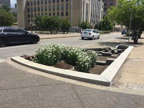
Increased summer heat & drought means we should be planting massive quantities of shade trees now to lower the urban heat island effect. Fruit trees too so people can harvest the fruit when food production is increasingly hampered by climate change. We need to reduce the amount of impervious surfaces and increase the use of rain gardens to collect runoff.
Rain gardens were included in the Tucker rebuild.
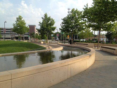
We can collect storm water in large cisterns to use for irrigation. Uptown Circle in Normal IL is a great example:
The center of Normal’s Uptown Circle uses storm water as a design feature. 2012 photo
Sustainable stormwater management: capturing, storing, cleansing and recycling much of the stormwater in Uptown Normal, is one of the key elements of the project. Run-off is collected from several streets adjoining the Circle and is stored in a 75,000 gallon underground cistern. This cistern, which was recycled from a 60” diameter storm sewer line being abandoned as part of the associated infrastructure improvements, serves as a detention device for water providing relief to the community’s watershed. Water captured and retained in the cistern is then either used for irrigation of turf and plant material in the district or is introduced into the Circle where it begins a journey through a ‘living plaza’ creating a legible demonstration of sustainability in an urban environment. Signage explains the process and value to children and adults.
In the Circle, water collected in the cistern is pumped through a series of terraced filtration bogs where it is cleansed as it flows slowly around the circle through the plant material, passing over several weirs and through a scupper wall before falling into a collection pool. At this point, water is pumped into an underground reservoir, treated by a UV filter and then circulated through a shallow stream-like water feature. Park visitors have access to this highly engaging watercourse as it flows around the circumference of the circle, mirroring the flow of traffic beyond and providing an acoustic buffer to the sound of traffic. This feature also detains and encourages evaporation of water that would have otherwise become runoff as part of a storm event. This process also eases the heat island effect in this urban district. (Architonic)
Commercial properties, apartment complexes, and such will need large cisterns too. Single family homes will need small cisterns for watering shade trees and necessary vegetable gardens.
Older housing needs to be renovated to be far more energy efficient. Large McMansions in the suburbs will not age well, owners will downsize rather than invest the necessary sums to retrofit them. Large amounts of wall area exposed to the hot sun will make them hard to cool. Plant shade trees now. Municipalities will resist the desire to subdivide these excessively large structures into multiple units. There was a time when stately mansions in the Central West End couldn’t be given away (ok, sold for cheap) — we’ll see that with 30-40 year old suburban McMansions.
New housing built should be multi-family but not like our apartment with 3 exterior walls and one shared wall. No, new housing should be like our former loft with 3 shared walls and one narrow exterior wall — a wall that’s often shaded. Of course, this new multi-family housing must including affordability — not just high-end central corridor units.
Auto window tinting is very common in Oklahoma & Texas, we’ll see more of that here — not for privacy but reducing heat gain cars. We’ve tinted our south-facing bedroom windows that get some sun at times of the day. Our 2nd bedroom’s windows have a well-placed shade tree.
There are probably a millions things more we can do collectively as a city/region over the next decade or so to help us handle the future. For those who think climate change is a hoax, just keep your head buried in the sand while the rest of us try to solve fast-approaching problems.
MetroLink will have extra trains ready to go on Saturday as hundreds of thousands of Blues fans head downtown to celebrate with the Stanley Cup Champions, the St. Louis Blues.
With five downtown MetroLink stations a block or two away from the Stanley Cup Parade, MetroLink is the perfect option while avoiding road construction, traffic and parking issues.
What about residents of North & South city that don’t yet have light rail?
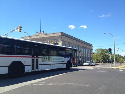
2012: The #11 MetroBus crosses Jefferson Ave. heading west on Chippewa Ave.
Yes, MetroBus is a good option. Since Metro’s marketing folks don’t seem to want to suggest their own service I decided to step up and show you some suggested routes. Those of us who live in the city are well-served by transit, if we take it downtown that’ll ease congestion for everyone downtown. We’re not all served by light rail.
My focus is on MetroBus routes that enter downtown, though other routes could connect you to say the Forest Park MetroLink station — the 90 Hampton MetroBus serves both North, West, & South city. Of course the busiest MetroBus route, the 70 Grand, is an excellent option to reach MetroLink.
Because the Civic Center Transit Center is on the south edge of downtown (Downtown West technically) the south routes have less disruption from downtown events. However, most should be good, assuming you get downtown prior to street closures.
From South City:
8 Bates-Morganford winds its way through the city on streets like: Loughborough, Holly Hills, Tower Grove, Shaw, Russell, 12th/Tucker, and — Bates & Morganford. On Saturday this bus runs every hour, the last bus before the parade arrives at Civic Center at 11:40am.
10 Gravois-Lindell originates at Gravois & Hampton, cutting a diagonal path through south city along Gravois. Saturday morning this bus runs every 30 minutes.
11 Chippewa runs every 40 minutes on Saturday morning, from the Shrewsbury MetroLink Station along Landsdowne, Chippewa, and Jefferson. Normally the EB bus heading into downtown goes up to Market but tomorrow it’ll use Chouteau to 14th to avoid the parade.
20 South Broadway serves South County & South City including South County Mall, Jefferson Barracks, far south city, & Soulard. On Saturday it runs every hour.
30 Arsenal is another route running through south city between Shrewsbury MetroLink and Civic Center Transit Center in Downtown West. It primarily uses Arsenal for the East-West portion and Broadway for the North-South. The 30 runs every 40 minutes on Saturdays.
31 Chouteau connects the Maplewood/Manchester MetroLink Station to Civic Center via Manchester in both the county & city, and Chouteau. It runs every hour on Saturdays.
73 Carondelet serves both south county & city, every 30 minutes on Saturdays. Streets include: Michigan, Virginia, Osceola, Meramec, Cherokee, Lemp, and Truman Parkway.
80 Park-Shaw connects the CWE MetroLink to Civic Center via south city. Similar to 8 above, but the route is different. Every hour on Saturdays.
From North City — most will have a reroute in the downtown area due to the parade.
4 Natural Bridge travels mostly along Natural Bridge, then using Parnell/Jefferson, usually to Market. Due to the parade it’ll reroute by staying on Jefferson to Chouteau to 14th to Civic Center. The 4 runs every 40 minutes on Saturdays.
19 St. Louis Ave connects the Rock Road MetroLink to Civic Center, through the heart of The Ville. It runs every 40 minutes on Saturdays. Because 14th will be closed for the parade it’ll reroute to Olive, Jefferson, Chouteau, 14th — if you take this bus to the parade I suggest exiting at 14th & Olive. The 19 runs every 40 minutes on Saturdays.
32 ML King also connects Rock Road to Civic Center, a little further south than the 19. It uses ML King & Cass for East-West and 9th/10th for North-South. At Washington & Tucker it will due a massive reroute along Washington to Jefferson, to Chouteau, to 14th. Avoid the reroute and exit before Tucker. The 32 runs every 40 minutes on Saturdays.
40 North Broadway connects Riverview to downtown, primarily along Broadway. Like the 32 it reroutes along Washington from Broadway to Jefferson — avoid all that and get off at Broadway & Washington! The 40 runs every hour on Saturdays.
41 Lee runs every 40 minutes between Riverview and downtown/Civic Center on streets like Thekla, Emerson, Lee, Kossuth, 20th, Carr. Like other bus routes, avoid the very long reroutes by exiting at 14th & Olive.
74 Florissant runs every half hour connecting north county to downtown via West/North Florissant. Like others, exit at 14th & Olive to avoid the long reroute.
From West City:
10 Gravois-Lindell was mentioned above on the South City section, but for those in midtown it’s a good option to get to Civic Center. It’ll reroute at Jefferson to Chouteau so either stay on the bus to Civic Center or exit at Olive & Jefferson and walk to the parade start at 18th & Market. Or take it WB to the CWE to catch the train downtown.
94 Page runs every 40 minutes on Saturdays connecting Westport Plaza via Wellston to Civic Center. In the city it primarily uses Page, 18th, Market. Because of the parade it’ll reroute at 18th & Olive to Jefferson, Chouteau. Either get off at 18th & Olive or continue to Civic Center.
96 Market Street Shuttle runs every hour on Saturdays. This is an option for SLU/Harris Stowe students. It’ll reroute at Jefferson to Chouteau.
97 Delmar connects Clayton to Civic Center via the Delmar/Loop MetroLink, running every 30 minutes on Saturdays. In the city it primarily uses Delmar, Compton (briefly) and Washington. Due to the parade it’ll reroute at Washington to Jefferson, to Chouteau.
The links above are to the regular map for each route, for a list of all MetroBus routes click here. Again, if you live in the city and plan to attend the parade please walk, bike, or use transit — bus and/or rail. The cash fare each way is $2 — have $1 bills because you can’t get change on the bus. If you need to take more than one bus or bus plus rail you’ll need $3 each way for a transfer. For exact times, stop locations, etc use Google Maps, Apple Maps, the Transit App, or Metro’s Trip Planner.
Street parking isn’t free on Saturday, and lots will be charging a lot. Uber/Lyft will likely have surge pricing, plus will have to deal with lots of traffic. Take transit — light rail or MetroBus.
May 15, 2019Environment, FeaturedComments Off on Opinion: Climate Change Making Natural Weather More Intense, Frequent
The St. Louis region has experienced flooding events since its founding, so it’s easy to think current flooding is usual Spring flooding.
The St. Louis riverfront the afternoon of May 5, 2019
It’s not.
The impact of climate change on snowfall in the Midwest and Plains is uncertain, but projections suggest that heavy snow events will become more likely in the northern Great Plains.
David Robinson, a professor at Rutgers University who manages the Global Snow Lab, said that in some areas where climate change causes winter temperatures to warm above freezing more often, more winter precipitation may fall as rain. But other areas may experience more snow.
“As the cold temperatures get closer to freezing, there’s more moisture being held by the atmosphere,” he said. “So ironically, there are some areas that should warm up and get snowier because the temperatures will still be below freezing.” (Yale Climate Connections)
Hers’s another way to look at the connection:
Climate scientists often use a baseball analogy to explain the connection between climate change and extreme weather.
Martha Shulski, Nebraska’s state climatologist, describes the analogy this way:
Say you’ve got a home run hitter and you put him on steroids. He still hits home runs, but now he’s hitting the balls farther and getting home runs more frequently.
That’s how climate change influences weather: It can increase the intensity and frequency of extreme events. (Omaha World-Herald)
Let me repeat that last point — extreme events will be more frequent and intense.
Here are the results of the recent non-scientific Sunday Poll:
Q: Agree or disagree: Our current flooding is normal, has nothing to do with climate change.
Strongly agree: 5 [25%]
Agree: 2 [10%]
Somewhat agree: 1 [5%]
Neither agree or disagree: 1 [5%]
Somewhat disagree: 2 [10%]
Disagree: 3 [15%]
Strongly disagree: 5 [25%]
Unsure/No Answer: 1 [5%]
The following is not safe for work due to f-bombs, but it’s worth watching:
I saw the above as part of an episode of Last Week Tonight with John Oliver — you can watch the full 20 minutes here (again, NSFW).
May 13, 2019Environment, Featured, NeighborhoodsComments Off on Neighborhood Streetlights Still On Because Electrical Station Is Blocked
A month ago I posted about how My Neighborhood’s Street Lights Are Always On. To get this resolved I sent the link to the blog post to the folks at the St. Louis Citizens Service Bureau (CSB). As always, the promptly responded.
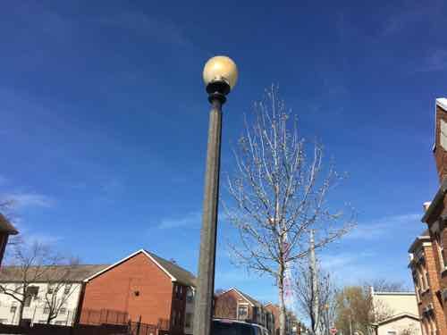
Here’s one of the many images of street lights on during the day included on my April 12th post.
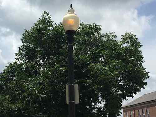
These lights are supposed to be pedestrian-scaled are also used frequently throughout the neighborhood. Many have the globe canted like this one. Carr at 8th
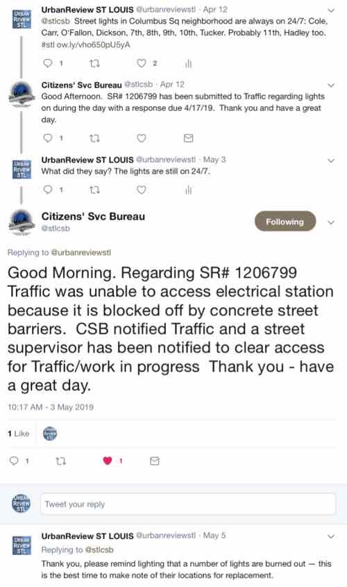
The CSB said lighting department was to respond by April 17th. On May 3rd the lights were still on so I replied asking what’s going on.
Click above to view the thread on Twitter
Yes, the lights have been on in my entire neighborhood for months (years?) because a concrete barrier is blocking access. I went searching to see if I could figure out the location of the blocked access to the electrical station.
Manhole cover at 6th & Carr Streets. This might be the blocked electrical station
I”m not sure the above is the blocked location in question. In September 2014 it’s partially covered, and more so in August 2017. Another nearby cover remains accessible.
Again, I don’t know if this is the correct location for the neighborhood electrical station workers need to access to get the street lights to come on only at night. All I know is the street lights, except the ones that are burnt out, remain on 24/7 a month after I notified the city.
AARP Livibility Index
The Livability Index scores neighborhoods and communities across the U.S. for the services and amenities that impact your life the most
Built St. Louis
historic architecture of St. Louis, Missouri – mourning the losses, celebrating the survivors.
Geo St. Louis
a guide to geospatial data about the City of St. Louis