Urban Flooding May Be The New Normal In St. Louis Region
The St. Louis region is no stranger to flooding — from the slowly rising Mississippi River (think 1993) and from flash floods overwhelming creeks, rivers, and man-made drainage.
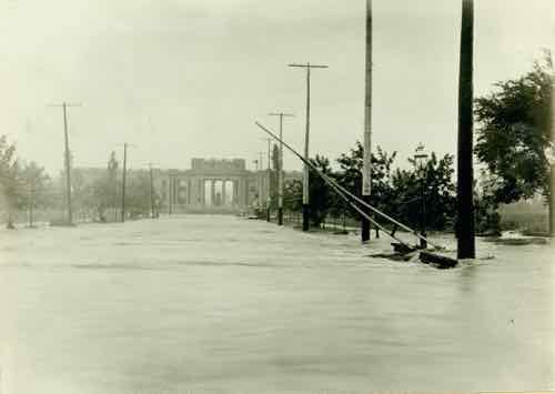
On the afternoon of Aug. 19, 1915, remnants of a hurricane reached St. Louis from Texas. Heavy and steady rainfall fell through the next day, dumping a total of 7.4 inches across the area. (6.85 inches on Aug. 20 remains the one-day record in St. Louis.)
The River Des Peres rushed from its banks, swamping long stretches of Delmar and Lindell boulevards, Manchester Avenue and other streets. People were stranded on the Wabash Railroad platform at Delmar (now a Metrolink station) by a seven-foot-deep current 200 yards wide. Firefighters reached them with ladders and used boats to rescue residents of Maple and Hodiamont avenues. (Post-Dispatch)
More than a century later flooding is still a major problem in the region.
First, let’s talk about some definitions:
Flash Floods
These quick-rising floods are most often caused by heavy rains over a short period (usually six hours or less). Flash floods can happen anywhere, although low-lying areas with poor drainage are particularly vulnerable. Also caused by dam or levee breaks or the sudden overflow of water due to a debris or ice jam, flash floods combine the innate hazards of a flood with speed and unpredictability and are responsible for the greatest number of flood-related fatalities.
Urban Flooding
Flash floods, coastal floods, and river floods can occur in urban areas, but the term “urban flooding” refers specifically to flooding that occurs when rainfall—not an overflowing body of water—overwhelms the local stormwater drainage capacity of a densely populated area. This happens when rainfall runoff is channeled from roads, parking lots, buildings, and other impervious surfaces to storm drains and sewers that cannot handle the volume. (Natural Resources Defense Council)
The term “urban flooding” better describes what we’ve recently experienced in the region.
From July 22, 2019:
The ensuing floods inundated streets and businesses in Eureka, displaced residents from a University City apartment complex, caused sewage overflows and prompted a spate of rescues around the area for motorists stranded in high water.
In Eureka — no stranger to flood damage from the adjacent Meramec River in recent years — the intense, early-morning rain flooded streets of the Old Town business district. Police said they had no reports of injuries.
The flooding happened between about 3 a.m. and 5 a.m. Monday, police said. The National Weather Service said local reports indicated Eureka received about 5.5 inches of rain overnight. (Post-Dispatch)
From August 14, 2019:
Flash floods that closed roads and delayed the start of the school year in Granite City are being blamed on the perfect storm: torrential rain, an outdated and inadequate storm drainage system, and political finger pointing.
A thunderstorm dropped between 5 and 7 inches of rain on the central and northern areas of Granite City Sunday night and into Monday morning, flooding the city and turning its roads into waterways. The southern part of the city received roughly 4 inches of rain.
“There was a deluge of water in a short time and the area couldn’t drain fast enough,” Madison County Chairman Kurt Prenzler said. “It was storm on top of storm.” (Belleville New Democrat)
From August 21, 2019:
Flash flooding causing water rescues and major problems for drivers. Video shows water covering 141 at Interstate 44 in Valley Park.
Police have blocked off 141 to keep cars from driving through the high water.
Most of the rescues dispatched for first responders were in the Valley Park and Fenton area. (Fox2)
Route 141 in Valley Park has routinely flooded, but one of the objectives of MoDot’s $25 million 141 at I-44 project, completed last year, was to reduce flash flooding — the contractor’s proposal included “Improved drainage to reduce the possibility of flash flooding.”
From August 26, 2019:
Flash flooding left drivers stranded and closed roads and highways across the St. Louis area Monday morning.
A flash flood warning was in effect during the morning commute for most of St. Louis County, the city and areas west. The warning was allowed to expire at 10:15 a.m. Some areas reported getting rain at a rate of 1-3 inches per hour. (KSDK)
Last week KMOV reported on a couple rebuilding their lives/home after the August flooding in Granite City. The couple didn’t have flood insurance — I’ll let them explain why they didn’t.
Michelle and Michael are working hard to put their home back together. They don’t have flood insurance because they said they are not in a flood zone and were told they didn’t need it.
“This has never happened in 25 years. Never,” Michelle explained. (KMOV)
It had never happened in 25 years and their home was not in a flood zone! Unfortunately, this is likely the new normal — non-flood zone areas will become overwhelmed by concentrated rains. Homes that had never flooded before will be flooded.
We’ve simply paved over too much land, our drainage systems can’t keep up when inundated with high volumes of rain. Do we invest in beefed up drains throughout the region? Do we begin to remove impervious materials to allow water to drain naturally? Somewhere in between?
— Steve Patterson