Poll: Which two of the four Bus Rapid Transit (BRT) routes would you like to see planners seek federal funding

Last week regional transportation planners presented four Bus Rapid Transit (BRT) being considered. Soon two will be picked to submit for federal funding.

Four alternative BRT routes, click image to view larger version

I attended the presentation at City Hall and participated in the audience voting using hand held devices. They asked a couple of questions to help them in their decision. To keep things simple I’m just asking which two of the four BRT routes should move forward with a request for federal funding.

From MovingTransitForward.org:

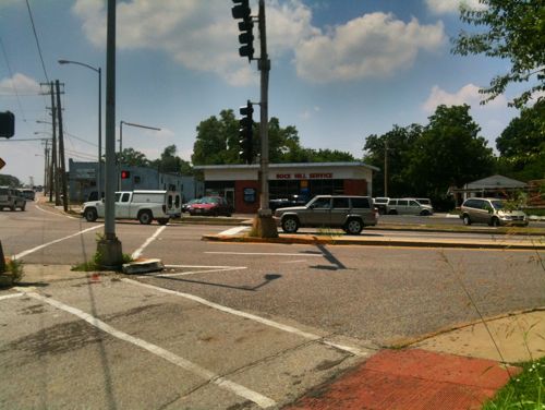
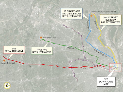
These four potential BRT routes are options for improving transit connections between St. Louis County and the City of St. Louis. One of the study’s main goals is to address the need for quick, direct travel from neighborhoods north and south of Downtown St. Louis to employers located in north and west St. Louis County. The “Central Corridor” stretching from Downtown St. Louis to the Central West End and Clayton still holds the region’s largest concentration of jobs, but the largest job growth is occurring in places like Chesterfield, Earth City, and St. Charles – areas easily accessible by highway, but currently not by public transit. The type of BRT service currently being studied is intended to expand access and improve travel time to those job opportunities – of particular importance to reverse commuters traveling to major job centers in suburban areas – while also providing a premium transit alternative for car commuters. The Rapid Transit Connector Study will identify candidates for Metro’s first two BRT routes; Metro will continue to work with the region to identify future BRT routes. Other transit options identified in Moving Transit Forward, such as expansions of the MetroLink System, are intended to meet other long-term goals such as strengthening neighborhoods and encouraging transit-oriented development.
Alternatives analysis involves evaluating the performance of each alternative along parameters including ridership, expanded access to key destinations, travel time savings, and land use benefits. These technical outcomes will be combined with public input to identify the two potential projects most likely to meet project goals, benefit the region, and successfully compete for federal funding.

One final meeting will be held this Tuesday:

September 17, 2013
5:30-7:30 p.m., open house with presentation at 6:30 p.m.
Chesterfield City Hall, Council Chambers
690 Chesterfield Pkwy W.
Chesterfield, MO 63017

The downtown inset can be viewed here.

You may not like any of the four, however, I’ve not allowed any custom answers so you can’t suggest any other routes. These four need to be narrowed to two. I did provide “none” as an option as well as “unsure/no answer.” The poll is in the right sidebar (desktop layout).

— Steve Patterson


Observations On Public Transit

September 14, 2013 Featured, Public Transit 27 Comments

In the past few weeks I’ve gotten a couple of 20-somethings to ride the bus system here. Both had ridden MetroLink light rail, but not MetroBus.

The #11 (Chippewa) MetroBus on 14th next to Peabody
The #11 (Chippewa) MetroBus on 14th St next to Peabody Opera House, 8:24pm

Here are some observations, in no particular order, about transit:

  1. People who say they’d ride their local transit system if it didn’t suck have probably never ridden it enough (ever?) to understand how to use it. Dissing your local transit service is an accepted narrative.
  2. Americans visit Europe and marvel at their efficient public transit and walkable cities, yet resume driving everywhere upon return.
  3. A first time transit rider is more intimidated by bus  than light rail/streetcar.
  4. Related, people willingly try rail (light rail or streetcar), but not bus.
  5. People compare bus vs car travel time, often concluding the bus takes too long. I say I can’t do enough email, social media, or casual reading while driving.
  6. Transit naysayers are the same people who drive to the gym, circling the parking lot for a spot near the door.

These are my personal observations, they’re neither right or wrong.

— Steve Patterson


Crossing Manchester Rd (MO 100) at McKnight

Recently I wanted to cross Manchester Rd, state highway 100, at McKnight. I quickly found out doing so is far from ideal in a wheelchair.  On the surface it looks good: crosswalks, pedestrian signals, etc.  Let me show you one glaring problem I discovered:

Looking north across Manchester at McKnight
Looking southwest from the NE corner of Manchester & McKnight
Close up of cut out for those crossing McKnight
Close up of cut out for those crossing McKnight. Attractive, huh?
But those trying to cross Manchester are out of luck

Over the last 20+ years three out of the four corners at this intersection have been redeveloped, and Rock Hill has been trying nearly as long on the fourth. Why is this still an issue? Who cut out part? How long ago?

2011
The cutout existed in 2011. I drove this day so I didn’t attempt to cross either McKnight or Manchester

Three possible culprits: Rock Hill, St. Louis County, or most likely, MoDOT. I suspect MoDOT because Manchester Road is Missouri State highway 100.  I hope to find out why this wasn’t addresses recently when a gas station replaced the stone Rock Hill church on this corner.

This is part of the problem with having too many entities: municipal, county, & state.

— Steve Patterson


Gas Station Replaced Rock Hill Church Built By Slaves

For more than a century a modest stone church stood in what later became the City of Rock Hill. Built by slaves in the 19th century, it couldn’t compete with a gas station + convenience store in the 21st century.

rock hill church
Rock Hill Church, 2011
Same view two years later
Now on the corner a sign notes current gas prices and a monument notes the history that was lost
Now on the corner a sign displays gas prices and a monument notes the history that was lost
Close up of the plaques on the stone monument

I’ve been told the church was “fully integrated” because the Marshall family required their slaves to attend the church they built. A little feel-good revisionist history?

There’s nothing to feel good about on this site. This is now a sprawl corner like thousands of others in St. Louis County. What once made a positive contribution to the sidewalk experience has been reduced to a monument few will read as that would require exiting their car and actually walking a bit.

— Steve Patterson


Asphalt Accessibility

September 11, 2013 Accessibility, Featured 1 Comment

Recently I defended the city’s planned use of asphalt to bridge the gap between a sidewalk that sank next to a water main lid (see post).  One comment started an interesting side thread: “Then let’s do this at every intersection that lacks a curb ramp!”

So today I’m going to show you uses of asphalt that are both acceptable & unacceptable, and try to explain the difference.

Acceptable

Asphalt was just added at 11th & St. Louis. This intersection has never been ADA compliant, still isn't.
Asphalt was just added at 11th & St. Louis. This intersection has never been ADA compliant, still isn’t.
Aspalt added to transition between two levels of the sidewalk

In both cases it looks like a half-ass fix, because they are. When you have very little money you must often make due. These weren’t ADA-compliant before and they still aren’t now. In both cases though, I can now get through where I couldn’t before.

Unacceptable

During the $70 million dollar library renovation I emailed this pic to director Waller McGuire, noting how high the ramp was above the street level.
Asphalt was the solution, but this isn't ADA-compliant. In such a major project I see no valid excuse. This was either poor planning or execution.
Asphalt was the solution, but this isn’t ADA-compliant. In such a major project I see no valid excuse. This was either poor planning or execution.

This case is like the step at Park Pacific across the street, a major project with new concrete that ended up non-compliant. Not only was this poured inches above the street level, it is pointing into the intersection. This corner should’ve had one directional ramp for 14th and another for Olive. The other ramps around the library have similar problems.

If I had to chose between non-ADA compliant where I had to pick another route or non-ADA compliant where I (and others) can still get through I’ll always pick the latter. Just as I’ll always expect new work to be done correctly.

— Steve Patterson


Advertisement


[custom-facebook-feed]

Archives

Categories

Advertisement


Subscribe