Five years ago today the normally quiet Lafayette Square neighborhood was rocked by a massive explosion at the Praxair industrial gas facility on Chouteau:
ST. LOUIS – A blaze at an industrial plant sent huge fireballs shooting into the sky Friday afternoon, casting a towering cloud of black smoke over the area as traffic backed up and nearby residents evacuated their homes.
There were no injuries, St. Louis Fire Chief Sherman George said. There also was no word on the cause of the rapid-fire series of spectacular explosions at Praxair Distribution, which processes propane and other gases for industrial use. (Source)
Video from a nearby resident:
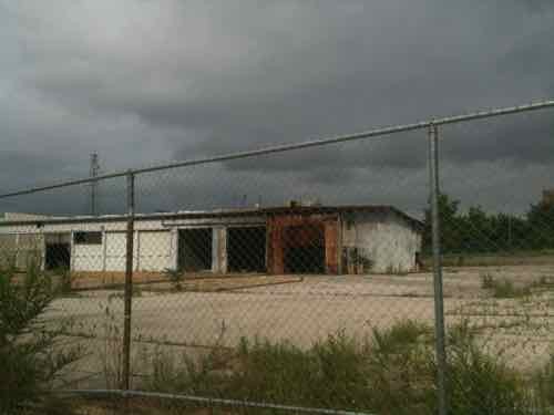
Today the building and site remain vacant. The 4 acre site, located at 2210 Chouteau, is listed for $2,250,000.
ABOVE: the burned out structure remains
Nearby residents started Praxair Watch to oppose the reopening of the facility.
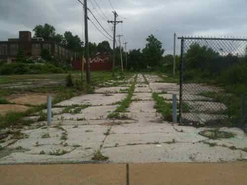
The 2.105 acre site to the east is listed for $750,000. Between the two sites is a former street, Mackay Place:
ABOVE: the former Mackay Place with the Praxair site on the right
This former street is owned by the same limited liability corporation that owns the site to the east.
The Praxair explosion was featured on an episode of the History Channel’s Modern Marvels as an “engineering disaster.”
One task facing the selected teams in The City * The Arch * The River Competition to incorporate the Illinois side of the Mississippi River into their solutions. Last month I took my wheelchair across the Eads Bridge to check out the situation.
ABOVE: pedestrian sidewalk on the Eads Bridge
I was pleasantly surprised by the number of pedestrians crossing the river on foot. Granted, it was a very nice afternoon.
ABOVE: East St. Louis riverfront May 2010
From the bridge you can see the casino and the grain elevator on the east bank of the river.
ABOVE: Cargil grain elevator, East St. Louis IL
Up close the industrial nature of the working facility is pleasing but just as you pass the view changes dramatically.
You come upon the Malcolm W. Martin Memorial Park. The park contains two elements that can be seen from Missouri. First is the overlook:
Statue of Malcolm W. Martin at the top of the overlook.
The other feature is the geyser. Four times per day the geyser shoots water into the air, provided it is not too windy.
Most of the time the water is still.Four small foutains around the edge start before the main jet of water.The geyser is very impressive but it only runs for 10-15 minutes at a timeUnfortunately getting to and from the Eads Bridge on foot (or wheelchair) is less than ideal
I suggest visiting the Malcolm W. Martin Memorial Park on the next nice day we have. I hope the design teams come up with a good way to get from the Eads Bridge to the park.
I love the thousands of 19th century buildings in St. Louis. Many have been designated as historic with placement on the National Register of Historic Places. I think I love our 19th century street pattern even more than the structures that fit into the spaces between the streets. But little by little our fine network of public streets is being destroyed.
Midtown in 1998
One of the biggest cases is Delmar in Midtown. Delmar used to run uninterrupted from downtown through the city and out to the suburbs. At Spring St it had a slight jog and the angled street (above) helped facilitate the continuous flow of vehicles (private & mass transit) and pedestrians on Delmar.
A recent article talks about the importance of the street grid and it’s intersections:
It’s a little counterintuitive, but it turns out that having lots of intersections is really important for neighborhood walkability and transit use. (Source)
The graphic from the article is so compelling I thought you should see it:
The three images are the same scale. More streets and intersections means more walkability and fewer cars, reduced pollution, etc. Urban Planners in the early 20th century knew this. Harland Bartholomew and his contemporaries sought to reduce intersections so traffic could flow faster.They wanted wide streets — but fewer of them. Rather than multiple choices of streets to take, on foot or while driving, you were given one — the newly widened roads, and later the freeway.
AARP Livibility Index
The Livability Index scores neighborhoods and communities across the U.S. for the services and amenities that impact your life the most
Built St. Louis
historic architecture of St. Louis, Missouri – mourning the losses, celebrating the survivors.
Geo St. Louis
a guide to geospatial data about the City of St. Louis